Category:De Modderige Bol, Goëngahuizen
Jump to navigation
Jump to search
| Object location | | View all coordinates using: OpenStreetMap |
|---|
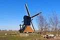
windmill in Goëngahuizen, Netherlands  | |||||
| Upload media | |||||
| Instance of | |||||
|---|---|---|---|---|---|
| Location | Goëngahuizen, Smallingerland, Friesland, Netherlands | ||||
| Has use |
| ||||
| Heritage designation |
| ||||
| Source of energy | |||||
 | |||||
|
This is a category about rijksmonument number 34001
|
| Address |
|
Media in category "De Modderige Bol, Goëngahuizen"
The following 5 files are in this category, out of 5 total.
-
 De Modderige Bol Goengahuizen 04.JPG 1,024 × 768; 86 KB
-
 Goaiïngahuzen, spinnekopmûne De Modderige Bol.jpg 2,938 × 1,957; 3.28 MB
-

-
 Goaiïngahuzen, spinnekoppen 'De Modderige Bol' en 'Jansmûne'.jpg 3,146 × 2,105; 3.48 MB
-
 Mûne "De Modderige Bol", Goaiïngahuzen.jpg 1,936 × 1,296; 1.17 MB

_en_%27Jansm%C3%BBne%27_(op_de_eftergr%C3%BBn).jpg)

