Category:De Korenbloem, Ulvenhout
Jump to navigation
Jump to search
| Object location | | View all coordinates using: OpenStreetMap |
|---|
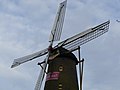
Nederlands: Afbeeldingen van de molen de Korenbloem, Molenstraat 23, 4851 VL Ulvenhout. Gelegen in Ulvenhout behorende bij de gemeenten Breda en Alphen-Chaam in de provincie Noord-Brabant in het zuiden van Nederland. Het is een rijksmonument
|
This is a category about rijksmonument number 30511
|
windmill in Ulvenhout, Netherlands  | |||||
| Upload media | |||||
| Instance of | |||||
|---|---|---|---|---|---|
| Location | Ulvenhout, Breda, North Brabant, Netherlands | ||||
| Street address |
| ||||
| Has use | |||||
| Heritage designation |
| ||||
| Source of energy | |||||
 | |||||
Media in category "De Korenbloem, Ulvenhout"
The following 11 files are in this category, out of 11 total.
-
 De Korenbloem, Ulvenhout P1640929.jpg 3,000 × 4,000; 4.66 MB
-
 De Korenbloem, Ulvenhout P1640930.jpg 4,000 × 3,000; 5.51 MB
-
 De Korenbloem, Ulvenhout P1640931.jpg 4,000 × 3,000; 6.14 MB
-
 De Korenbloem, Ulvenhout P1640935.jpg 4,000 × 3,000; 4.11 MB
-
 Korenmolen - Ulvenhout - 20211571 - RCE.jpg 772 × 1,200; 168 KB
-
 Korenmolen, het steken van de nieuwe roeden - Ulvenhout - 20211572 - RCE.jpg 1,200 × 1,183; 261 KB
-
 Molen De Korenbloem, Ulvenhout 2024-08-06.jpg 3,000 × 4,000; 4.08 MB
-
 Molen De Korenbloem, Ulvenhout achterkant 2024-08-06.jpg 3,600 × 4,800; 5.23 MB
-
 Molen, Molenstraat 23, aanzicht - Ulvenhout - 20211573 - RCE.jpg 816 × 1,200; 168 KB
-
 Overzicht van de molen - Ulvenhout - 20384648 - RCE.jpg 2,050 × 2,323; 683 KB
-
 P1010724De Korenbloem Ulvenhout.JPG 2,448 × 3,264; 3.4 MB


