Category:De Korenbloem, Oploo
Jump to navigation
Jump to search
| Object location | | View all coordinates using: OpenStreetMap |
|---|
windmill in Oploo, Netherlands  | |||||
| Upload media | |||||
| Instance of | |||||
|---|---|---|---|---|---|
| Location | Oploo, Land van Cuijk, North Brabant, Netherlands | ||||
| Street address |
| ||||
| Located on street |
| ||||
| Has use | |||||
| Heritage designation |
| ||||
| Source of energy | |||||
 | |||||
|
This is a category about rijksmonument number 31771
|
| Address |
|
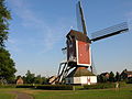
Nederlands: De Korenbloem is een standerdmolen, waarvan het bouwjaar onbekend is.
Media in category "De Korenbloem, Oploo"
The following 44 files are in this category, out of 44 total.
-
 2007-09-16 17.28 Oploo, molen foto1.JPG 3,072 × 2,304; 1.91 MB
-
 Achterzijde kast - Oploo - 20361342 - RCE.jpg 1,200 × 1,200; 203 KB
-
 De Korenbloem Oploo kruibank.jpg 2,226 × 1,660; 542 KB
-
 De Korenbloem Oploo maalstoel.jpg 1,704 × 2,272; 888 KB
-
 De Korenbloem Oploo onderzetel.jpg 1,704 × 2,272; 1.11 MB
-
 De Korenbloem Oploo standerd.jpg 1,704 × 2,272; 1.2 MB
-
 De Korenbloem Oploo vangbalk.jpg 1,704 × 2,272; 934 KB
-
 De Korenbloem Oploo varkenswiel.jpg 1,541 × 2,122; 718 KB
-
 De Korenbloem Oploo wiekenkruis.jpg 1,704 × 2,272; 661 KB
-
 De Korenbloem Oploo.jpg 1,704 × 2,272; 646 KB
-
 De Korenbloem trapzijde Oploo.jpg 1,704 × 2,272; 603 KB
-
 Exterieur OVERZICHT - Oploo - 20264687 - RCE.jpg 786 × 1,200; 174 KB
-
 Exterieur OVERZICHT VANAF WATERRADMOLEN - Oploo - 20264686 - RCE.jpg 1,200 × 805; 259 KB
-

-

-

-

-

-

-
 Gesloten voet van standerdmolen - AMR Molenfoto - 20538789 - RCE.jpg 1,200 × 900; 113 KB
-
 Korenmolen "De Korenbloem", aanzicht - Oploo - 20177391 - RCE.jpg 1,200 × 1,192; 183 KB
-
 Korenmolen "De Korenbloem", aanzicht - Oploo - 20177392 - RCE.jpg 1,200 × 1,181; 167 KB
-
 Oploo 2Molens.JPG 2,288 × 1,712; 742 KB
-
 Overzicht - Oploo - 20177395 - RCE.jpg 1,200 × 804; 265 KB
-
 Overzicht - Oploo - 20177396 - RCE.jpg 1,200 × 803; 231 KB
-
 Overzicht van standerdmolen - Oploo - 20177394 - RCE.jpg 804 × 1,200; 156 KB
-
 Overzicht van standerdmolen - Oploo - 20403497 - RCE.jpg 797 × 1,200; 157 KB
-
 Overzicht voorgevel en linker zijgevel watermolen - Oploo - 20375694 - RCE.jpg 1,200 × 795; 182 KB
-
 Overzicht voorgevel watermolen - Oploo - 20375695 - RCE.jpg 1,200 × 795; 198 KB
-
 Overzicht windmolen, standerdmolen - Oploo - 20375698 - RCE.jpg 795 × 1,200; 180 KB
-
 Overzicht windmolen, standerdmolen - Oploo - 20375699 - RCE.jpg 795 × 1,200; 179 KB
-
 Standaardmolen - Oploo - 20177397 - RCE.jpg 776 × 1,200; 135 KB
-
 Standaardmolen, aanzicht - Oploo - 20177402 - RCE.jpg 1,200 × 1,171; 204 KB
-
 Standaardmolen, in restauratie - Oploo - 20177398 - RCE.jpg 1,200 × 1,167; 195 KB
-
 Standaardmolen, in restauratie - Oploo - 20177399 - RCE.jpg 1,200 × 1,161; 212 KB
-
 Standaardmolen, in restauratie - Oploo - 20177400 - RCE.jpg 1,200 × 1,169; 192 KB
-
 Standaardmolen, teren van schaliëndak - Oploo - 20177403 - RCE.jpg 1,200 × 1,164; 331 KB
-
 Standaardmolen, vergane hoekstijl met tempelbalken - Oploo - 20177401 - RCE.jpg 1,200 × 1,170; 364 KB
-

-
 Vergezicht met gesloten standerdmolen - AMR Molenfoto - 20538783 - RCE.jpg 1,200 × 900; 74 KB
-
 Watermolen Standaardmolen - Oploo - 20177405 - RCE.jpg 795 × 1,200; 150 KB
-
 Waterrad en Standaardmolen, overzicht - Oploo - 20177406 - RCE.jpg 1,200 × 1,174; 301 KB
-
 Zijaanzicht - Oploo - 20361341 - RCE.jpg 1,200 × 1,200; 193 KB
-
 Zijaanzicht en achterzijde kast - Oploo - 20361343 - RCE.jpg 1,200 × 1,200; 190 KB


