Category:De Hoop, Sumar
Jump to navigation
Jump to search
| Object location | | View all coordinates using: OpenStreetMap |
|---|
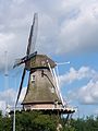
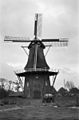
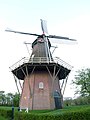
windmill in Sumar, Netherlands  | |||||
| Upload media | |||||
| Instance of | |||||
|---|---|---|---|---|---|
| Location | Sumar, Tytsjerksteradiel, Friesland, Netherlands | ||||
| Located on street |
| ||||
| Has use | |||||
| Heritage designation |
| ||||
| Source of energy | |||||
 | |||||
|
This is a category about rijksmonument number 35683
|
| Address |
|
Media in category "De Hoop, Sumar"
The following 12 files are in this category, out of 12 total.
-
 20210702 molen de Hoop1 Sumar.jpg 3,456 × 5,184; 2.68 MB
-
 20210702 molen de Hoop2 Sumar.jpg 5,184 × 3,456; 4.21 MB
-
 20210702 molen de Hoop3 Sumar.jpg 3,456 × 5,184; 3.71 MB
-
 2022 Sumar, nôtmûne 'De Hoop'.jpg 2,751 × 1,831; 2.51 MB
-
 De Hoop Sumar.JPG 1,944 × 2,592; 820 KB
-
 Korenmolen "De Hoop" - Sumar - 20206702 - RCE.jpg 784 × 1,200; 157 KB
-
 Korenmolen "De Hoop" - Sumar - 20206703 - RCE.jpg 788 × 1,200; 133 KB
-
 Molen De Hoop Sumar.jpg 2,352 × 3,136; 1.78 MB
-
 Molen De Hoop. Suameer..JPG 4,608 × 3,456; 1.75 MB
-
 Nôtmûne 'De Hoop', Sumar.jpg 2,000 × 1,334; 1.18 MB
-
 Sumar, De Hoop.jpg 3,842 × 5,376; 6.62 MB
-
 Sumar, nôtmûne 'De Hoop'.jpg 2,000 × 1,334; 1.47 MB


