Category:De Hoop, Garsthuizen
Jump to navigation
Jump to search
| Object location | | View all coordinates using: OpenStreetMap |
|---|
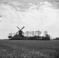
windmill in Garsthuizen, Netherlands  | |||||
| Upload media | |||||
| Instance of | |||||
|---|---|---|---|---|---|
| Location | Garsthuizen, Eemsdelta, Groningen, Netherlands | ||||
| Has use | |||||
| Heritage designation |
| ||||
| Source of energy | |||||
 | |||||
|
This is a category about rijksmonument number 34512
|
| Address |
|
Media in category "De Hoop, Garsthuizen"
The following 36 files are in this category, out of 36 total.
-

-

-

-

-

-

-

-
 Achtkantmolen - Garsthuizen - 20075274 - RCE.jpg 796 × 1,200; 187 KB
-
 Close-up van achtkante stellingmolen - AMR Molenfoto - 20541196 - RCE.jpg 1,200 × 900; 204 KB
-
 De Hoop.jpg 640 × 480; 49 KB
-
 Garsthuizen - De Hoop (1).jpg 4,896 × 3,264; 14.86 MB
-
 Garsthuizen - De Hoop (2).jpg 4,845 × 3,230; 13.87 MB
-
 Huis bij achtkante stellingmolen - AMR Molenfoto - 20541191 - RCE.jpg 1,200 × 900; 190 KB
-
 Korenmolen "De Hoop" - Garsthuizen - 20075278 - RCE.jpg 1,200 × 1,179; 258 KB
-
 Korenmolen "De Hoop", aanzicht - Garsthuizen - 20075270 - RCE.jpg 1,200 × 1,186; 217 KB
-
 Korenmolen "De Hoop", aanzicht - Garsthuizen - 20075271 - RCE.jpg 1,200 × 1,186; 235 KB
-
 Korenmolen "De Hoop", aanzicht - Garsthuizen - 20075273 - RCE.jpg 1,200 × 1,170; 246 KB
-

-
 Korenmolen - Garsthuizen - 20075267 - RCE.jpg 1,200 × 1,167; 285 KB
-
 Korenmolen bij boerderij - Garsthuizen - 20075265 - RCE.jpg 1,200 × 1,174; 277 KB
-
 Korenmolen met woning, Smijdingeweg 44 - Garsthuizen - 20075260 - RCE.jpg 820 × 1,200; 251 KB
-
 Korenmolen, aanzicht - Garsthuizen - 20075264 - RCE.jpg 1,200 × 1,178; 325 KB
-

-
 Korenmolen, detail - Garsthuizen - 20075263 - RCE.jpg 1,200 × 1,172; 260 KB
-
 Korenmolen, Smijdingeweg 44 - Garsthuizen - 20075262 - RCE.jpg 816 × 1,200; 270 KB
-
 Molen - Garsthuizen - 20075259 - RCE.jpg 852 × 1,200; 250 KB
-
 Molen - Garsthuizen - 20075276 - RCE.jpg 1,200 × 788; 225 KB
-
 Molen - Garsthuizen - 20075277 - RCE.jpg 1,200 × 788; 270 KB
-
 Molen de Hoop Garsthuizen.jpg 703 × 474; 76 KB
-
 Molen De Hoop Garsthuizen.jpg 1,616 × 1,054; 447 KB
-

-
 Stenen onderbouw molen - Garsthuizen - 20075275 - RCE.jpg 1,200 × 794; 244 KB
-

-
 Voorgevel - Garsthuizen - 20075258 - RCE.jpg 1,200 × 805; 246 KB
-
 Woonhuis bij achtkante stellingmolen - AMR Molenfoto - 20541194 - RCE.jpg 1,200 × 900; 257 KB
-
 Zicht op Garsthuizen-met molen De Hoop.jpg 1,296 × 972; 232 KB


.jpg)
.jpg)


,_aanzicht_-_Garsthuizen_-_20075272_-_RCE.jpg)


