Category:De Haag
Jump to navigation
Jump to search
| Object location | | View all coordinates using: OpenStreetMap |
|---|
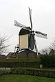
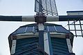
windmill in Beuningen, Netherlands  | |||||
| Upload media | |||||
| Instance of | |||||
|---|---|---|---|---|---|
| Location | Beuningen, Gelderland, Netherlands | ||||
| Street address |
| ||||
| Has use | |||||
| Heritage designation |
| ||||
| Source of energy | |||||
| Different from | |||||
 | |||||
|
This is a category about rijksmonument number 9536
|
| Address |
|
Media in category "De Haag"
The following 81 files are in this category, out of 81 total.
-
 Beuningen (Gld) Molen De Haag (01).JPG 3,240 × 4,320; 4.63 MB
-
 Beuningen (Gld) Molen De Haag (02).JPG 4,320 × 3,240; 5.32 MB
-
 Beuningen (Gld) Molen De Haag (03).JPG 3,240 × 4,320; 4.4 MB
-
 Beuningen (Gld) Molen De Haag (04).JPG 4,320 × 3,240; 5.1 MB
-
 Beuningen (Gld) Molen De Haag plaquette.JPG 4,320 × 3,240; 5.76 MB
-
 Beuningen (Gld) molenhuis Molenstraat 54, met molen.JPG 4,320 × 3,240; 5.63 MB
-
 Beuningen - Molen De Haag.jpg 1,001 × 1,500; 839 KB
-
 Den Haag in het centrum.jpg 6,000 × 4,000; 4.05 MB
-
 Exterieur OVERZICHT MOLEN ZEER IN VERVAL - Beuningen - 20299575 - RCE.jpg 1,200 × 1,200; 237 KB
-

-
 Molen bij molenstraat nr.5 - Beuningen - 20034347 - RCE.jpg 1,197 × 1,200; 268 KB
-
 Molen bij molenstraat nr.54m - Beuningen - 20034348 - RCE.jpg 1,200 × 1,200; 248 KB
-
 Molen De Haag (1).jpg 6,348 × 4,249; 3.79 MB
-
 Molen De Haag (1a).jpg 6,992 × 4,666; 3.45 MB
-
 Molen De Haag (2).jpg 7,360 × 4,912; 3.55 MB
-
 Molen De Haag (3).jpg 4,421 × 6,624; 3.58 MB
-
 Molen De Haag (4).jpg 4,756 × 7,255; 3.77 MB
-
 Molen De Haag (4a).jpg 6,256 × 4,175; 4.06 MB
-
 Molen De Haag (5).jpg 4,637 × 7,128; 3.37 MB
-
 Molen De Haag (6).jpg 7,360 × 4,912; 3.12 MB
-
 Molen De Haag (7).jpg 7,360 × 4,912; 2.96 MB
-
 Molen De Haag (8).jpg 6,005 × 4,133; 3.21 MB
-
 Molen De Haag (9).jpg 6,470 × 4,276; 3.86 MB
-
 Molen De Haag (9a).jpg 6,256 × 4,175; 4.09 MB
-
 Molen De Haag achtermolen (1).jpg 4,249 × 6,461; 3.5 MB
-
 Molen De Haag achtermolen (2).jpg 6,624 × 4,421; 3.69 MB
-
 Molen De Haag achtermolen (3).jpg 6,334 × 4,282; 3.47 MB
-
 Molen De Haag achtermolen (4).jpg 3,656 × 5,439; 3.71 MB
-
 Molen De Haag achtermolen steenrondsel.jpg 5,888 × 3,930; 3.81 MB
-
 Molen De Haag achtermolen steenspil.jpg 4,903 × 3,296; 4.09 MB
-
 Molen De Haag bovenas hals (1).jpg 6,437 × 4,206; 3.89 MB
-
 Molen De Haag bovenas hals (2).jpg 3,650 × 5,456; 3.78 MB
-
 Molen De Haag bovenas pen.jpg 6,306 × 4,291; 3.58 MB
-
 Molen De Haag bovenas.jpg 6,256 × 4,175; 3.71 MB
-
 Molen De Haag bovenwiel achterzijde.jpg 6,651 × 4,489; 3.73 MB
-
 Molen De Haag bovenwiel met varkenswiel (1).jpg 6,256 × 4,175; 3.88 MB
-
 Molen De Haag bovenwiel met varkenswiel (2).jpg 5,741 × 3,813; 3.61 MB
-
 Molen De Haag bovenwiel pal.jpg 4,272 × 6,156; 3.76 MB
-
 Molen De Haag kap voorzijde.jpg 5,888 × 3,930; 3.53 MB
-
 Molen De Haag luiwerk gaffelwiel.jpg 5,888 × 3,930; 3.61 MB
-
 Molen De Haag luiwerk lichtboom pasbrug.jpg 4,421 × 6,624; 3.7 MB
-
 Molen De Haag luiwerk varkenswiel.jpg 6,256 × 4,175; 3.71 MB
-
 Molen De Haag roeplaatje.jpg 6,314 × 4,357; 2.36 MB
-
 Molen De Haag spoorstijlen.jpg 4,421 × 6,624; 4.41 MB
-
 Molen De Haag standerd klauw.jpg 6,624 × 4,421; 3.91 MB
-
 Molen De Haag standerd kruisplaat.jpg 6,283 × 4,273; 3.38 MB
-
 Molen De Haag standerd steekbanden zetel.jpg 7,034 × 4,408; 3.34 MB
-
 Molen De Haag standerd stormpen smeernippel.jpg 6,559 × 4,359; 3.36 MB
-
 Molen De Haag standerd.jpg 3,613 × 5,676; 3.96 MB
-
 Molen De Haag steenlijst inscriptie.jpg 6,433 × 4,129; 3.43 MB
-
 Molen De Haag vang koubout.jpg 4,044 × 6,194; 3.49 MB
-
 Molen De Haag vangbalk ezel.jpg 4,175 × 6,256; 3.9 MB
-
 Molen De Haag vangbalk lekenpen.jpg 4,055 × 6,451; 3.57 MB
-
 Molen De Haag vangtrommel lekenpen (1).jpg 6,256 × 4,175; 3.76 MB
-
 Molen De Haag vangtrommel lekenpen (2).jpg 6,624 × 4,421; 3.93 MB
-
 Molen De Haag voormolen (1).jpg 4,421 × 6,624; 4.09 MB
-
 Molen De Haag voormolen maalbak (1).jpg 4,912 × 7,360; 3.99 MB
-
 Molen De Haag voormolen maalbak (2).jpg 7,360 × 4,912; 3.82 MB
-
 Molen De Haag voormolen schuddebak.jpg 4,421 × 6,624; 3.84 MB
-
 Molen De Haag voormolen steenkraan (1).jpg 6,624 × 4,421; 3.8 MB
-
 Molen De Haag voormolen steenkraan (2).jpg 7,083 × 4,608; 3.97 MB
-
 Molen De Haag voormolen steenspill.jpg 6,425 × 4,298; 3.44 MB
-
 Molen De Haag zetel slekken (1).jpg 7,360 × 4,912; 3 MB
-
 Molen De Haag zetel slekken (2).jpg 6,771 × 4,557; 3.34 MB
-
 Molen De Haag zetel slekken (3).jpg 6,374 × 4,342; 3.73 MB
-
 Molen De Haag zetelluik.jpg 6,624 × 4,421; 3.9 MB
-
 Overzicht - Beuningen - 20361085 - RCE.jpg 1,200 × 1,189; 186 KB
-
 Overzicht - Beuningen - 20361086 - RCE.jpg 1,199 × 1,200; 253 KB
-
 Overzicht - Beuningen - 20366854 - RCE.jpg 1,200 × 1,199; 187 KB
-
 Standerdmolen - Beuningen - 20034343 - RCE.jpg 1,200 × 1,181; 324 KB
-
 Standerdmolen - Beuningen - 20034344 - RCE.jpg 1,200 × 1,172; 211 KB
-
 Standerdmolen - Beuningen - 20034345 - RCE.jpg 1,200 × 1,184; 276 KB
-
 Standerdmolen - Beuningen - 20034351 - RCE.jpg 1,200 × 1,200; 232 KB
-
 Standerdmolen aan de molenstraat bij nr.5 - Beuningen - 20034346 - RCE.jpg 1,181 × 1,200; 332 KB
-
 Standerdmolen, exterieur in verval - Beuningen - 20034355 - RCE.jpg 1,200 × 1,200; 265 KB
-
 Standerdmolen, exterieur in verval - Beuningen - 20034356 - RCE.jpg 1,200 × 1,200; 226 KB
-
 Standerdmolen, exterieur in verval - Beuningen - 20034357 - RCE.jpg 1,200 × 1,200; 264 KB
-
 Standerdmolen, exterieur overzicht - Beuningen - 20034354 - RCE.jpg 1,195 × 1,200; 306 KB
-
 Standerdmolen, overzicht - Beuningen - 20034350 - RCE.jpg 1,200 × 1,200; 239 KB
-
 Standerdmolen, overzicht in verval - Beuningen - 20034353 - RCE.jpg 1,200 × 1,200; 257 KB
-
 Standermolen, detail molen - Beuningen - 20034352 - RCE.jpg 1,200 × 1,200; 322 KB
_Molen_De_Haag_(01).JPG)
_Molen_De_Haag_(02).JPG)
_Molen_De_Haag_(03).JPG)
_Molen_De_Haag_(04).JPG)
_Molen_De_Haag_plaquette.JPG)
_molenhuis_Molenstraat_54,_met_molen.JPG)


.jpg)
.jpg)
.jpg)
.jpg)
.jpg)
.jpg)
.jpg)
.jpg)
.jpg)
.jpg)
.jpg)
.jpg)
.jpg)
.jpg)
.jpg)
.jpg)


.jpg)
.jpg)


.jpg)
.jpg)


.jpg)
.jpg)
.jpg)
.jpg)
.jpg)

.jpg)
.jpg)

.jpg)
.jpg)
.jpg)


