Category:De Eendracht, Sebaldeburen
Jump to navigation
Jump to search
| Object location | | View all coordinates using: OpenStreetMap |
|---|
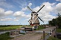
windmill in Grootegast, the Netherlands  | |||||
| Upload media | |||||
| Instance of | |||||
|---|---|---|---|---|---|
| Location | Sebaldeburen, Westerkwartier, Groningen, Netherlands | ||||
| Has use |
| ||||
| Heritage designation |
| ||||
| Source of energy | |||||
 | |||||
Nederlands: Poldermolen De Eendracht, Sebaldeburen
|
This is a category about rijksmonument number 18781
|
| Address |
|
Media in category "De Eendracht, Sebaldeburen"
The following 6 files are in this category, out of 6 total.
-
 20170715 04 Sebaldeburen - Flickr - Sjaak Kempe.jpg 5,184 × 3,456; 2.18 MB
-
 5656 Sebaldeburen.JPG 2,288 × 1,712; 2.07 MB
-
 De Eendracht, 1887.jpg 3,362 × 2,242; 2.3 MB
-
 De Eendracht, anno 1887.jpg 2,592 × 3,888; 3.51 MB
-
 Watermolen "De Eendracht" - Sebaldeburen - 20199134 - RCE.jpg 1,200 × 1,174; 235 KB
-
 Watermolen "De Eendracht" - Sebaldeburen - 20199135 - RCE.jpg 1,200 × 1,172; 274 KB


