Category:De Blinkert
Jump to navigation
Jump to search
| Object location | | View all coordinates using: OpenStreetMap |
|---|
Nederlands: Afbeeldingen van de duintop De Blinkert nabij de Duinlustweg in Overveen gelegen in de provincie Noord-Holland in het noordwesten van Nederland. Gelegen naast Kraantje Lek.
 | |||||
| Upload media | |||||
| Instance of | |||||
|---|---|---|---|---|---|
| Location | Bloemendaal, North Holland, Netherlands | ||||
 | |||||
Media in category "De Blinkert"
The following 22 files are in this category, out of 22 total.
-
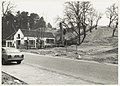
 Café Rastaurant Kraantje Lek met de Blinkert aan de Duinlustweg. NL-HlmNHA 54015578.JPG 2,139 × 1,528; 530 KB
-

-

-
 De Blinkert bij Kraantje Lek in Overveen.jpg 1,164 × 824; 389 KB
-
 De Blinkert bij Kraantje Lek in Overveen.JPG 2,140 × 1,535; 592 KB
-
 De Blinkert Kraantje Lek.jpg 3,264 × 2,448; 1.97 MB
-
 Gezicht op de Blinkert, bij Kraantje Lek.jpg 3,000 × 2,632; 3.31 MB
-
 Gezicht op Kraantje Lek en de De Blinkert te Overveen. NL-HlmNHA 1477 53011079.JPG 3,252 × 2,823; 3.42 MB
-
 Kraantje Lek.jpg 3,072 × 2,048; 3 MB
-
 Kraantje lek.jpg 2,848 × 3,628; 1.65 MB
-
-
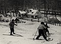
 Skiën op de Blinkert bij Kraantje Lek. NL-HlmNHA 54005636.JPG 2,895 × 2,168; 646 KB
-

-

-
 Wintersport op de Blinkert in Overveen, Bestanddeelnr 913-5862.jpg 3,648 × 2,406; 1.75 MB
-
 Wintersport op de Blinkert in Overveen, Bestanddeelnr 913-5863.jpg 3,648 × 2,406; 1.68 MB
-
 Wintersport op de Blinkert in Overveen, Bestanddeelnr 913-5864.jpg 3,648 × 2,406; 2.19 MB
-
 Wintersport op de Blinkert in Overveen, Bestanddeelnr 913-5865.jpg 3,648 × 2,406; 1.98 MB
-
 Wintersport op de Blinkert in Overveen, Bestanddeelnr 913-5866.jpg 3,648 × 2,406; 2.47 MB
-
 Wintersport op de Blinkert in Overveen, Bestanddeelnr 913-5867.jpg 3,648 × 2,406; 1.98 MB
-
 Wintersport op de Blinkert in Overveen, Bestanddeelnr 913-5868.jpg 3,648 × 2,406; 1.44 MB
-
 Wintersport op de Blinkert in Overveen, Bestanddeelnr 913-5869.jpg 3,648 × 2,406; 1.72 MB


