Category:Danger signs in the United States
Jump to navigation
Jump to search
Media in category "Danger signs in the United States"
The following 44 files are in this category, out of 44 total.
-
 "Danger - Lead Air" - Stop Northern Metal Recycling Protest, Minneapolis (29432646272).jpg 3,781 × 2,475; 3.99 MB
-
 108th Wing fuel systems airmen help Stratotanker return fuel 121208-Z-AL508-024.jpg 5,616 × 3,744; 4.01 MB
-

-

-

-

-

-
-

-
 210915-F-MJ351-2014 - 3 Geronimo paratroopers fire anti-tank weapons (Image 16 of 17).jpg 4,872 × 3,252; 7.38 MB
-
 480 volts on Caltrain Stadler KISS.jpg 4,032 × 3,024; 5.76 MB
-
-
 America's Highways 1776–1976 - page 131.jpg 1,039 × 2,338; 2.2 MB
-
 Avalon Area Patapsco Valley State Park 34.JPG 4,608 × 3,456; 4.65 MB
-
 Bomb-damaged home of Arthur Shores (5 September 1963).jpg 4,537 × 3,006; 5.76 MB
-
 Cades Cove - October 2023 - Sarah Stierch 06.jpg 4,032 × 3,024; 4.73 MB
-
 Camp Parapet Powder Magazine Dec 1976 Signs.jpg 1,489 × 1,199; 355 KB
-
 Cave Point County Park sign, Sevastopol, Door County, Wisconsin.jpg 1,520 × 2,688; 2.15 MB
-
 Chambers St Centre St td (2022-03-04) 25.jpg 5,472 × 3,648; 6.98 MB
-
 Coney Island Mermaid Parade 2005 - 01.jpg 1,063 × 1,600; 268 KB
-
 Crescent Park Mch2014 River Danger New Orleans.jpg 4,608 × 3,456; 5.79 MB
-
 Crescent Park New Orleans - Danger.jpg 4,032 × 3,024; 9.26 MB
-
 Danger (4824911289).jpg 1,200 × 803; 724 KB
-
 Danger - Biohazard.jpg 2,681 × 1,890; 3.36 MB
-
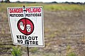 Eerie caution sign about use of pesticides.jpg 799 × 533; 98 KB
-
 Explosives Warning Sign, Alta Mountain, Utah.jpg 4,032 × 3,024; 4.99 MB
-
 FEMA - 32096 - Cars drives though flooded street in an Oklahoma neighborhood.jpg 2,896 × 1,944; 4.45 MB
-
 FEMA - 44625 - Road closed flooded by flood waters in Oklahoma.jpg 3,000 × 1,993; 6.55 MB
-
 Fireplace from hotel that used to be at Big Four (15129034799).jpg 2,048 × 1,536; 2.39 MB
-
 Fumigating and Disinfecting Team New Orleans 1939 a019946 Crop.jpg 2,317 × 2,252; 1.32 MB
-
 Green River in Kanaskat-Palmer State Park 27.jpg 6,000 × 4,000; 13.6 MB
-
 Green River in Kanaskat-Palmer State Park, 02.jpg 4,198 × 2,799; 8.83 MB
-
 Hawks Nest Dam 2022g.jpg 6,240 × 4,160; 15.62 MB
-
 Hoover Dam, Wikiexp 06.jpg 4,912 × 3,264; 4.57 MB
-
 Info Toxic Clams Whidbey Mar23 A7R 03949.jpg 3,757 × 5,009; 12.75 MB
-
 Lava-damaged Hawaiian Sign.jpg 2,304 × 1,728; 1.75 MB
-
 Lowa9th20Mch06NDangerSignCraneLeveework.jpg 2,592 × 1,944; 1.32 MB
-
 North Omaha Airport danger sign.jpg 2,832 × 3,776; 2.65 MB
-
 North Omaha Airport main gate.jpg 4,032 × 3,024; 3.35 MB
-
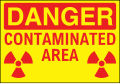 OSHA-Like Radiation Sign - Danger! Contaminated Area 01.svg 1,000 × 692; 24 KB
-
 OSHA-Like Radiation Sign - Danger! Contaminated Area 02.svg 1,000 × 692; 28 KB
-
 Somewhere in Boston (39509853632).jpg 2,400 × 1,600; 1.69 MB
-
 Spring Gap Forbay Inlet - panoramio.jpg 4,000 × 3,000; 2.52 MB
-
 WoodlandPlaqueminesGatorsAndSnakes.JPG 2,816 × 2,112; 2.36 MB
.jpg)


.jpg)


.jpg)


_25.jpg)


.jpg)


.jpg)


.jpg)

