Category:Dam of Bort-les-Orgues
Jump to navigation
Jump to search
| Object location | | View all coordinates using: OpenStreetMap |
|---|
reservoir  | |||||
| Upload media | |||||
| Instance of |
| ||||
|---|---|---|---|---|---|
| Location | |||||
| Date of official opening |
| ||||
| Nominal power output |
| ||||
| Length |
| ||||
| Height |
| ||||
| Drainage basin | |||||
| Reservoir created | |||||
 | |||||
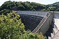
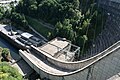
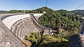
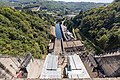
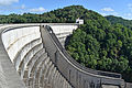
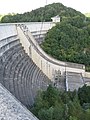
Français : Le barrage de Bort-les-Orgues retient les eaux de la Dordogne. Il est partagé entre les communes de Bort-les-Orgues (département de la Corrèze, région Nouvelle-Aquitaine) au sud et de Lanobre (Cantal, région Auvergne-Rhône-Alpes) au nord.
Media in category "Dam of Bort-les-Orgues"
The following 39 files are in this category, out of 39 total.
-
 Barrage de bort les orgues 02.jpg 3,504 × 2,336; 1.68 MB
-
 Barrage de bort les orgues 11.jpg 3,504 × 2,336; 1.23 MB
-
 Barrage de Bort les Orgues.jpg 3,750 × 2,394; 1.02 MB
-
 Barrage de bort vue de la route.jpg 1,280 × 1,024; 199 KB
-
 Barrage de Bort-les-Orgues-1407.jpg 6,720 × 3,780; 12.9 MB
-
 Barrage de Bort-les-Orgues-1408.jpg 6,720 × 3,780; 19.76 MB
-
 Barrage de Bort-les-Orgues-1411.jpg 6,720 × 4,480; 17.59 MB
-
 Barrage de Bort-les-Orgues-1412.jpg 6,720 × 4,480; 24.32 MB
-
 Barrage de Bort-les-Orgues-1414.jpg 6,720 × 4,480; 24.07 MB
-
 Barrage de Bort-les-Orgues-1415.jpg 6,720 × 4,480; 26.52 MB
-
 Barrage de Bort-les-Orgues-1416.jpg 6,720 × 4,480; 26.67 MB
-
 Barrage de Bort-les-Orgues-1417.jpg 10,790 × 3,556; 24.7 MB
-
 Barrage de Bort-les-Orgues-2725.jpg 6,270 × 3,527; 13.4 MB
-
 Barrage de Bort-les-Orgues-2726.jpg 5,557 × 3,126; 12.81 MB
-
 Barrage de Bort-les-Orgues-2732.jpg 6,720 × 4,480; 23.33 MB
-
 Barrage de Bort-les-Orgues-2734.jpg 6,720 × 4,480; 26.94 MB
-
 Barrage de Bort-les-Orgues-2736.jpg 6,720 × 4,480; 26.72 MB
-
 Barrage de Bort-les-Orgues-2738.jpg 6,720 × 4,480; 18.21 MB
-
 Barrage de Bort-les-Orgues-2739.jpg 4,480 × 6,720; 20.12 MB
-
 Barrage de Bort-les-Orgues-2740.jpg 6,720 × 4,480; 16.09 MB
-
 Barrage de Bort-les-Orgues-2741.jpg 6,720 × 4,480; 16.54 MB
-
 Barrage de Bort-les-Orgues-2744.jpg 5,573 × 3,135; 9.59 MB
-
 Barrage-de-Borts-les-Orgues-sur-la-Dordogne-DSC 0233.jpg 6,000 × 4,000; 17.31 MB
-
 Bort-les-Orgues barrage roue turbine Kaplan axe vertical.JPG 2,448 × 3,264; 3.75 MB
-
 Bort-les-Orgues barrage vanne de tête.JPG 3,264 × 2,448; 3.66 MB
-
 Bort-les-Orgues barrage.JPG 3,264 × 2,448; 3.74 MB
-
 Bort-les-Orgues Dam - DPLA - 09959812f453b4c27393409b63967809.jpg 3,666 × 4,658; 1.76 MB
-
 Bort-les-Orgues Dam - DPLA - 3e532c3974a0e21c5ed166f1c28ded79.jpg 3,848 × 4,075; 2.61 MB
-
 Bort-les-Orgues Dam - DPLA - 6bc53e1e21f5c486a439b85ee7b4c10c.jpg 3,847 × 4,084; 2.11 MB
-
 Bort-les-Orgues Dam - DPLA - e06bd98c808cf09f1aa5002597c2b034.jpg 4,524 × 3,673; 1.98 MB
-
 Bort-les-Orgues Dam - DPLA - f222b1c96d41c9190eab92d4b48451a6.jpg 3,577 × 4,902; 2.65 MB
-
 Bort-les-Orgues roue de turbine.JPG 3,264 × 2,448; 3.93 MB
-
 Dam of Bort-les-Orgues downstream.jpg 2,112 × 2,816; 1.92 MB
-
 Dam of Bort-les-Orgues upstream.jpg 2,816 × 2,112; 1.83 MB
-
 Lac du barrage de bort.jpg 1,280 × 1,024; 125 KB
-
 Lanobre - barrage de Bort vu de Granges.jpg 5,472 × 3,648; 7.72 MB
-
 Lanobre - barrage de Bort-les-Orgues 20200807-01.jpg 5,472 × 3,648; 8.24 MB
-
 Lanobre - barrage de Bort-les-Orgues 20200807-02.jpg 5,253 × 3,502; 8.39 MB
-
 Lanobre - Usine de la Rhue.jpg 5,472 × 3,648; 5.96 MB


