Category:Dalton-le-Dale
Jump to navigation
Jump to search
English: Dalton-le-Dale is a small village in County Durham, in England. It is situated on the old A19 road between Seaham and Murton .
village in County Durham, England, UK | |||||
| Upload media | |||||
| Instance of | |||||
|---|---|---|---|---|---|
| Location | County Durham, North East England, England | ||||
| Population |
| ||||
 | |||||
Subcategories
This category has the following 2 subcategories, out of 2 total.
A
W
- Dalton Water Pumping Station (7 F)
Media in category "Dalton-le-Dale"
The following 15 files are in this category, out of 15 total.
-
 A19 southbound - geograph.org.uk - 6674777.jpg 640 × 494; 64 KB
-
 A19 southbound - geograph.org.uk - 6674783.jpg 640 × 480; 64 KB
-
 Dalton le Dale Community Hall - geograph.org.uk - 5028857.jpg 640 × 480; 550 KB
-
 Farmland towards the A19, Dalton le Dale - geograph.org.uk - 3219271.jpg 640 × 480; 121 KB
-
 Looking northwest from the old railway - geograph.org.uk - 3784185.jpg 4,608 × 3,456; 5.08 MB
-
 Ordnance Survey Cut Mark - geograph.org.uk - 5911689.jpg 1,024 × 625; 168 KB
-
 Row of houses in Dalton-le-Dale - geograph.org.uk - 314428.jpg 640 × 480; 65 KB
-
 Service station on the B1285 - geograph.org.uk - 3219285.jpg 640 × 480; 67 KB
-
 The A19 heading north - geograph.org.uk - 3219267.jpg 640 × 480; 81 KB
-
 The B1285 heading north - geograph.org.uk - 3219282.jpg 640 × 480; 86 KB
-
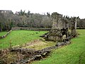 The remains of Dalden Tower - geograph.org.uk - 1706783.jpg 1,024 × 768; 314 KB
-
 Track to Dalton le Dale - geograph.org.uk - 5028853.jpg 640 × 427; 421 KB
-
 View NE from the railway - geograph.org.uk - 2910511.jpg 2,906 × 2,189; 1.29 MB
-
 View north from the old railway - geograph.org.uk - 3784189.jpg 4,608 × 3,456; 5.01 MB
-
 Walking in the glen 'Dalton le Dale' (10203541594).jpg 2,048 × 1,536; 1.39 MB


.jpg)