Category:Dalmarnock
Jump to navigation
Jump to search
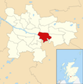
district in Glasgow City, Scotland, UK  | |||||
| Upload media | |||||
| Instance of | |||||
|---|---|---|---|---|---|
| Location |
| ||||
 | |||||
Subcategories
This category has the following 5 subcategories, out of 5 total.
C
- Cuningar Loop Park (12 F)
D
- Dalmarnock Bridge (10 F)
- Dalmarnock railway bridge (8 F)
- Dalmarnock railway station (41 F)
E
Media in category "Dalmarnock"
The following 67 files are in this category, out of 67 total.
-
 Andrew Muirhead & Son Limited, Dunn Street (geograph 6195189).jpg 1,024 × 683; 120 KB
-
 Andrew Muirhead and Son - geograph.org.uk - 2644555.jpg 640 × 480; 90 KB
-
 Apartments beside the River Clyde (geograph 6966577).jpg 1,024 × 768; 141 KB
-
 Auckland Wynd, Dalmarnock 2016-03-07.jpg 6,823 × 1,930; 2.17 MB
-
 Baltic Street - geograph.org.uk - 3683535.jpg 640 × 480; 111 KB
-
 Bernard Street, Dalmarnock - geograph.org.uk - 2644558.jpg 640 × 480; 98 KB
-

-
 Braidfauld and the River Clyde from the air (geograph 2987418).jpg 480 × 640; 155 KB
-
 Brownfield site at Parkhead (geograph 5647893).jpg 640 × 434; 155 KB
-
 Buildings in the Dalmarnock Athletes Village (geograph 5721747).jpg 1,600 × 1,200; 269 KB
-
 Clyde footbridge accessing Cuningar Loop Park (geograph 6778199).jpg 1,024 × 577; 155 KB
-
 Clyde Gateway (geograph 7167824).jpg 1,600 × 598; 269 KB
-
 Clyde Walkway at Dalmarnock (geograph 3894135).jpg 1,024 × 768; 766 KB
-
 Clyde Walkway at Dalmarnock - geograph.org.uk - 135599.jpg 640 × 480; 158 KB
-
 Clyde Walkway at Dalmarnock - geograph.org.uk - 341712.jpg 640 × 480; 134 KB
-
 Clyde Walkway at Shawfield (geograph 5266391).jpg 1,600 × 1,200; 343 KB
-
 Clyde Walkway near Dalmarnock - geograph.org.uk - 1322042.jpg 640 × 480; 138 KB
-
 Clyde Walkway near Dalmarnock - geograph.org.uk - 341707.jpg 640 × 480; 145 KB
-
 Clyde Walkway, Dalmarnock - geograph.org.uk - 1167875.jpg 640 × 480; 133 KB
-
 Clyde Walkway, Dalmarnock - geograph.org.uk - 1322085.jpg 640 × 480; 142 KB
-
 Clyde walkway, Dalmarnock - geograph.org.uk - 1330614.jpg 640 × 359; 91 KB
-
 Cycling by the Clyde, Dalmarnock - geograph.org.uk - 135612.jpg 640 × 480; 123 KB
-
 Dalmarnock from Whitevale Tower.JPG 2,848 × 2,136; 2.84 MB
-
 Dalmarnock multi stripped (geograph 2691535).jpg 640 × 480; 17 KB
-
 Dalmarnock, Glasgow.jpg 600 × 398; 135 KB
-
 Disused works, Dalmarnock (geograph 5266297).jpg 1,600 × 1,200; 401 KB
-
 Dunn Street, (B763), Glasgow (geograph 6966560).jpg 800 × 600; 119 KB
-
 East End Regeneration Route (geograph 3062652).jpg 640 × 498; 117 KB
-
 East Glasgow from the air - geograph.org.uk - 5374226.jpg 640 × 480; 198 KB
-

-
 Fielden Street (geograph 3064177).jpg 640 × 415; 102 KB
-
 Glasgow 2014 Athletes Village from outside Emirates Arena.JPG 2,848 × 2,136; 3.09 MB
-
 Glasgow 2014 Athletes Village under construction.JPG 2,848 × 2,136; 3.15 MB
-
 Glasgow wards 2017 no09 Calton.png 2,000 × 2,040; 504 KB
-
 Glasgow, November 2017 (38220209131).jpg 4,608 × 3,456; 4.35 MB
-
 Houses on Vancouver Walk (geograph 6147485).jpg 1,024 × 768; 428 KB
-
 Police Headquarters, Rutherglen (geograph 5826319).jpg 1,600 × 1,200; 427 KB
-
 Police Scotland administrative headquarters (geograph 5266410).jpg 1,600 × 1,200; 434 KB
-
 Police Scotland building, Shawfield Drive (geograph 6195184).jpg 1,024 × 683; 120 KB
-
 River Clyde near Parkhead (geograph 5721736).jpg 1,600 × 1,200; 345 KB
-
 Shawfield smartbridge under construction.jpg 2,592 × 1,936; 1.29 MB
-
 Shawfield smartbridge.jpg 5,152 × 2,896; 5.42 MB
-
 Space Invaded - No 6 - Glassgie Graffers (5183319422).jpg 573 × 975; 415 KB
-
 Springfield Road - geograph.org.uk - 5650121.jpg 640 × 480; 148 KB
-
 Springfield Road - geograph.org.uk - 5650137.jpg 640 × 379; 120 KB
-
 Springfield Road - geograph.org.uk - 5650139.jpg 640 × 385; 124 KB
-
 Swanston Street (geograph 3683580).jpg 640 × 363; 90 KB
-
 Swanston Street - geograph.org.uk - 2447305.jpg 640 × 378; 91 KB
-
 Swanston Street - geograph.org.uk - 2447308.jpg 640 × 480; 130 KB
-
 Swanston Street - geograph.org.uk - 2447320.jpg 640 × 393; 94 KB
-
 Swanston Street - geograph.org.uk - 3683569.jpg 640 × 480; 106 KB
-
 Swanston Street - geograph.org.uk - 3683571.jpg 640 × 387; 97 KB
-
 Swanston Street at Poplin Street - geograph.org.uk - 2447303.jpg 640 × 411; 90 KB
-

-

-

-

-
 The Clyde 'Smart Bridge' (geograph 5317705).jpg 1,600 × 1,200; 292 KB
-
 The Clyde at Dalmarnock (geograph 5650109).jpg 640 × 480; 208 KB
-
 The Legacy Hub (geograph 5650125).jpg 640 × 480; 148 KB
-
 The River Clyde at Dalmarnock (geograph 5650108).jpg 640 × 480; 179 KB
-
 Thomas Stoddart Ltd bed factory (geograph 5650103).jpg 640 × 353; 97 KB
-
 Tower Block UK photo glw3-20 (Dalmarnock towers 1981).jpg 2,612 × 1,742; 792 KB
-
 Tower Block UK photo glw3-21.jpg 2,612 × 1,742; 657 KB
-
 View from the River Clyde bridge (geograph 6884370).jpg 3,000 × 2,000; 5.21 MB
-
 Approaching meander in the River Clyde - geograph.org.uk - 1167896.jpg 640 × 480; 150 KB
-
 River Clyde near Dalmarnock - geograph.org.uk - 134878.jpg 640 × 480; 75 KB
.jpg)

.jpg)


_(cropped).jpg)
.jpg)
.jpg)
.jpg)
.jpg)
.jpg)


.jpg)


.jpg)
.jpg)
,_Glasgow_(geograph_6966560).jpg)
.jpg)


.jpg)


.jpg)
.jpg)
.jpg)
.jpg)
.jpg)
.jpg)


.jpg)


.jpg)


.jpg)
.jpg)
.jpg)
.jpg)
.jpg)
.jpg)
.jpg)
.jpg)
.jpg)
.jpg)

.jpg)


.jpg)