Category:Curland
Jump to navigation
Jump to search
English: Curland is a village and civil parish in Somerset, England, situated south of Taunton in the Taunton Deane district. The village has a population of 141. The parish includes the hamlet of Abbey Hill.
a village located in Taunton Deane, United Kingdom  | |||||
| Upload media | |||||
| Instance of | |||||
|---|---|---|---|---|---|
| Location | Somerset West and Taunton, Somerset, South West England, England | ||||
| Population |
| ||||
 | |||||
Media in category "Curland"
The following 41 files are in this category, out of 41 total.
-
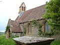 All Saints Church, Curland - geograph.org.uk - 169010.jpg 640 × 480; 121 KB
-
 Bridleway to Castle Neroche - geograph.org.uk - 3452398.jpg 1,600 × 1,067; 630 KB
-
 Castle Neroche Farm - geograph.org.uk - 1375226.jpg 640 × 480; 102 KB
-
 Castle Neroche trail - geograph.org.uk - 1044672.jpg 640 × 480; 138 KB
-
 Clearing, Castle Neroche Plantation - geograph.org.uk - 1375205.jpg 640 × 480; 140 KB
-
 Curland Methodist Chapel - geograph.org.uk - 157087.jpg 640 × 480; 87 KB
-
 Entrance to Middleroom Wood - geograph.org.uk - 4791948.jpg 1,024 × 768; 357 KB
-
 Entrance to Newton Bungalow - geograph.org.uk - 3452393.jpg 1,600 × 1,068; 528 KB
-
 Fallen tree, Castle Neroche - geograph.org.uk - 1374544.jpg 640 × 480; 137 KB
-
 Forest Drove bridleway to Batten's Green - geograph.org.uk - 3452396.jpg 1,600 × 1,067; 497 KB
-
 Higher Hare Farm - geograph.org.uk - 168596.jpg 640 × 480; 108 KB
-
 Home of Taunton Town Model Railway Club - geograph.org.uk - 4336073.jpg 1,024 × 794; 184 KB
-
 House near Curland - geograph.org.uk - 4336064.jpg 640 × 480; 74 KB
-
 Middleroom Lane - geograph.org.uk - 4791968.jpg 1,024 × 768; 349 KB
-
 Middleroom Lane - geograph.org.uk - 4792159.jpg 1,024 × 814; 366 KB
-
 Minor road, near Castle Neroche - geograph.org.uk - 1377277.jpg 640 × 480; 90 KB
-

-
 Road bends through the woods - geograph.org.uk - 1920267.jpg 640 × 480; 153 KB
-
 Road to Bell Vista - geograph.org.uk - 2354100.jpg 640 × 480; 142 KB
-
 Stone barn at Seymour Farm - geograph.org.uk - 4336066.jpg 1,024 × 768; 183 KB
-
 The Bailey, Castle Neroche - geograph.org.uk - 1374520.jpg 640 × 480; 117 KB
-

-
 Toppled gate near Curland Common - geograph.org.uk - 1920294.jpg 640 × 480; 91 KB
-
 Track on Newtown Farm - geograph.org.uk - 4792165.jpg 1,024 × 844; 283 KB
-
 Turning for Curland and Bickenhall - geograph.org.uk - 2354095.jpg 640 × 480; 89 KB
-
 Village Green, Curland - geograph.org.uk - 4336081.jpg 1,024 × 784; 206 KB
-
 Woodland path, through Castle Neroche - geograph.org.uk - 1374533.jpg 640 × 480; 145 KB
-
 Cottages on Cold Road - geograph.org.uk - 168738.jpg 640 × 480; 105 KB
-
 Curry Mallet Drove - geograph.org.uk - 157076.jpg 640 × 480; 107 KB
-
 Dommett Farm - geograph.org.uk - 168618.jpg 640 × 480; 110 KB
-
 Entrance to Great Boles - geograph.org.uk - 171579.jpg 640 × 480; 132 KB
-
 Famers' Inn, Slough Green - geograph.org.uk - 171580.jpg 640 × 480; 94 KB
-
 Folly Drove - geograph.org.uk - 157069.jpg 640 × 480; 132 KB
-
 Middleroom Lane - geograph.org.uk - 168668.jpg 640 × 480; 158 KB
-
 New Road near Whitty - geograph.org.uk - 168994.jpg 640 × 480; 91 KB
-
 Road to Blackwater and Blindmoor - geograph.org.uk - 449138.jpg 640 × 480; 112 KB
-
 Silver Street - geograph.org.uk - 168609.jpg 640 × 480; 91 KB
-
 Slough Green from Slough Hill - geograph.org.uk - 171582.jpg 640 × 480; 99 KB
-
 Trees on Barrington Hill - geograph.org.uk - 157072.jpg 640 × 480; 93 KB
-
 View from Hare Lane - geograph.org.uk - 168631.jpg 640 × 480; 92 KB
-
 Wesleyan Methodist Chapel, Slough Green - geograph.org.uk - 171583.jpg 640 × 480; 133 KB


