Category:Cumhuriyet, Sarıyer

From Wikimedia Commons, the free media repository
Jump to navigation Jump to search
<nowiki>Cumhuriyet; Cumhuriyet; Cumhuriyet; Cumhuriyet; Cumhuriyet; Cumhuriyet; Cumhuriyet; Cumhuriyet; Cumhuriyet; Cumhuriyet; Cumhuriyet; Cumhuriyet; Cumhuriyet; Cumhuriyet; Cumhuriyet; Cumhuriyet; Cumhuriyet; Cumhuriyet; Cumhuriyet; Cumhuriyet; Cumhuriyet; Cumhuriyet; Cumhuriyet; Cumhuriyet; Cumhuriyet; Cumhuriyet; Cumhuriyet; Cumhuriyet; Cumhuriyet; Cumhuriyet; ДжумхӀурийет (Сарийер); Sarıyer, İstanbul, Türkiye'de mahalle; neighborhood in Sarıyer, Istanbul, Turkey; mahalle in Sarıyer, Turkije; Cumhuriyet, Sarıyer</nowiki>
Cumhuriyet 
neighborhood in Sarıyer, Istanbul, Turkey
Upload media
Instance of
  • mahalle
Location
Population
  • 12,631 (2007)
  • 11,994 (2008)
  • 11,908 (2009)
  • 12,029 (2010)
  • 11,969 (2011)
  • 11,674 (2012)
  • 11,475 (2013)
  • 11,361 (2014)
  • 11,324 (2015)
  • 11,281 (2016)
  • 11,247 (2017)
  • 10,887 (2018)
  • 11,063 (2019)
  • 11,067 (2020)
  • 11,143 (2021)
  • 11,027 (2022)
  • 10,750 (2023)
Map41° 08′ 52.15″ N, 29° 02′ 04.99″ E
Authority file
Wikidata Q6079238
OpenStreetMap relation ID: 9644714
Edit infobox data on Wikidata

Subcategories

This category has only the following subcategory.

Media in category "Cumhuriyet, Sarıyer"

This category contains only the following file.
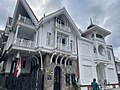