Category:Crumlin, Caerphilly
Jump to navigation
Jump to search
town and community in Caerphilly County Borough   | |||||
| Upload media | |||||
| Instance of | |||||
|---|---|---|---|---|---|
| Location | Caerphilly County Borough, Wales | ||||
| Population |
| ||||
| Area |
| ||||
 | |||||
Български: 300px|мини|Изглед от Кръмлин
Cymraeg: Tref ym mwrdeisdref sirol Caerffili yn ne Cymru yw Crymlyn (Saesneg: Crumlin). Saif yn nyffryn Afon Ebwy, bum milltir i'r gorllewin o dref Pont-y-pŵl.
English: Crumlin is a town in Caerphilly county borough in south Wales, situated in the Ebbw River valley [1], five miles west of Pontypool, within the historic boundaries of Monmouthshire.
Subcategories
This category has the following 6 subcategories, out of 6 total.
Media in category "Crumlin, Caerphilly"
The following 200 files are in this category, out of 698 total.
(previous page) (next page)-
 2010 Wales Caerphilly Community Crumlin map.svg 512 × 725; 375 KB
-
 2024 Wales Caerphilly Community Crumlin map.svg 512 × 725; 345 KB
-

-

-
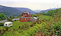
 A house off the Park Way - geograph.org.uk - 4015077.jpg 1,600 × 1,064; 607 KB
-
 A view from Sofrydd Road, Sofrydd - geograph.org.uk - 2635159.jpg 640 × 572; 123 KB
-
 A467 near Aberbeeg - geograph.org.uk - 2751435.jpg 640 × 480; 59 KB
-
 A467 near Glandwr - geograph.org.uk - 2751450.jpg 640 × 453; 66 KB
-

-
 A467-Kendon Road junction - geograph.org.uk - 2751473.jpg 640 × 480; 57 KB
-
 A472 east of Hafodyrynys - geograph.org.uk - 5646764.jpg 800 × 594; 202 KB
-
 A472 eastbound - geograph.org.uk - 2751506.jpg 640 × 454; 49 KB
-
 A472 pelican crossing, Hafodyrynys - geograph.org.uk - 5647149.jpg 800 × 530; 86 KB
-
 A472-A467 junction, Crumlin - geograph.org.uk - 5081589.jpg 5,184 × 3,456; 6.05 MB
-
 A487 heads north from Crumlin - geograph.org.uk - 5651382.jpg 640 × 481; 53 KB
-
 Aberbeeg Hospital, Aberbeeg - geograph.org.uk - 5228978.jpg 5,179 × 3,451; 3.83 MB
-
 Abertillery bus in Trinant - geograph.org.uk - 5231742.jpg 800 × 552; 103 KB
-
 Abingdon Floor Coverings, Pen-y-Fan Industrial Estate. - geograph.org.uk - 6766084.jpg 5,184 × 3,456; 5.82 MB
-
 ACF hut dwarfed by pylon, Sofrydd - geograph.org.uk - 2482500.jpg 568 × 640; 74 KB
-
 Across the valley towards Lewis Street, Swffryd - geograph.org.uk - 5081802.jpg 5,184 × 3,456; 3.1 MB
-

-
 Albertina Road, Treowen - geograph.org.uk - 2299843.jpg 640 × 414; 57 KB
-

-

-

-
 B4251 nears Oakdale Industrial Park - geograph.org.uk - 5651345.jpg 640 × 480; 41 KB
-

-

-
 Beech tree in field off Mynydd Llwyd Common - geograph.org.uk - 6509850.jpg 5,179 × 3,451; 5.13 MB
-
 Beehive Buildings, Crumlin - geograph.org.uk - 2752270.jpg 640 × 480; 68 KB
-
 Belvedere Close, Pentwyn - geograph.org.uk - 5229772.jpg 800 × 725; 100 KB
-
 Bench in Pen-y-fan Pond Country Park - geograph.org.uk - 4326368.jpg 800 × 542; 132 KB
-
 Bench overlooking Aberbeeg - geograph.org.uk - 1218438.jpg 640 × 480; 96 KB
-
 Bench with a view, Trinant - geograph.org.uk - 5234338.jpg 800 × 600; 161 KB
-

-

-
 Bends in road to Trinant - geograph.org.uk - 4717876.jpg 5,120 × 3,451; 5.31 MB
-
 Bethel Baptist Chapel, Crumlin - geograph.org.uk - 2752214.jpg 640 × 480; 79 KB
-
 Bont Pren boundary sign - geograph.org.uk - 5529692.jpg 800 × 605; 169 KB
-
 Bont Pren boundary sign detail - geograph.org.uk - 5529696.jpg 457 × 800; 137 KB
-

-

-
 Boundary of Mynydd Llwyd Common - geograph.org.uk - 6510612.jpg 5,179 × 3,451; 5.16 MB
-
 Boundary stone by gate, Mynydd Llwyd Common - geograph.org.uk - 6783687.jpg 5,179 × 3,451; 4.4 MB
-
 Bowling green, Llanhilleth - geograph.org.uk - 2765949.jpg 640 × 480; 83 KB
-
 Breakfast in Bread, Hafodyrynys - geograph.org.uk - 5529605.jpg 741 × 800; 152 KB
-
 Bridge over a railway line, Crumlin - geograph.org.uk - 2713163.jpg 640 × 480; 111 KB
-
 Bridge over dry overflow channel, Pen-y-fan Pond - geograph.org.uk - 6498938.jpg 5,179 × 3,451; 4.62 MB
-
 Bridleway near Pentrapeod - geograph.org.uk - 5236951.jpg 4,000 × 3,000; 4.53 MB
-
 Bridleway near Pentrapeod - geograph.org.uk - 5236958.jpg 4,000 × 3,000; 5.53 MB
-
 Bridleway to Manmoel Road - geograph.org.uk - 4616427.jpg 4,926 × 3,344; 5.95 MB
-
 Bridleway to Pen-y-fan Pond - geograph.org.uk - 4955610.jpg 5,048 × 3,366; 6.79 MB
-
 Bridleway, Sycamore House - geograph.org.uk - 4676367.jpg 5,062 × 3,371; 3.99 MB
-
 Broken stile, boundary of Mynydd Llwyd Common - geograph.org.uk - 6784087.jpg 5,179 × 3,451; 4.42 MB
-

-
 Bryn Brithdir, Oakdale - geograph.org.uk - 3986496.jpg 800 × 612; 159 KB
-
 BT phonebox, Trinant Terrace, Pentwyn - geograph.org.uk - 5233800.jpg 800 × 641; 113 KB
-

-

-

-
 Bute Place, Cwm Nant Gwynt - geograph.org.uk - 5220751.jpg 699 × 800; 145 KB
-
 Byway down hillside to Crumlin - geograph.org.uk - 5174696.jpg 5,179 × 3,451; 5.61 MB
-
 Byway to Pentrapeod - geograph.org.uk - 4987049.jpg 5,184 × 3,456; 6.19 MB
-
 Byway to Trinant from Crumlin - geograph.org.uk - 5236458.jpg 5,179 × 3,451; 5.48 MB
-
 Byway up to Ebbw Valley Walk - geograph.org.uk - 5174855.jpg 5,179 × 3,451; 6.31 MB
-
 Caer-ynys-isha, Kendon Road,Crumlin - geograph.org.uk - 1931787.jpg 640 × 480; 81 KB
-
 Caerphilly UK community map (Crumlin).svg 894 × 1,266; 474 KB
-
 Caravan storage at Kendon Farm - geograph.org.uk - 4717851.jpg 5,184 × 3,456; 5.49 MB
-
 Cattle behind Horeb Chapel, Trinant - geograph.org.uk - 5236000.jpg 5,179 × 3,451; 4.96 MB
-
 Cattle ^ old building, Tir-hunt - geograph.org.uk - 5157268.jpg 5,179 × 3,451; 5.14 MB
-
 Cedar Road, Pentwyn - geograph.org.uk - 5229695.jpg 800 × 566; 87 KB
-

-
 Cefn-crib Road, Hafodyrynys - geograph.org.uk - 4924115.jpg 5,184 × 3,456; 6.02 MB
-

-
 Checkpoint 10 on The Valleys 100 - geograph.org.uk - 4015085.jpg 1,600 × 1,064; 471 KB
-
 Checkpoint 10 on The Valleys 100 - geograph.org.uk - 4015088.jpg 1,600 × 1,064; 485 KB
-
 Checkpoint 10 on The Valleys 100 - geograph.org.uk - 4015104.jpg 1,600 × 1,064; 903 KB
-
 Checkpoint 10 on The Valleys 100, the marshals tent - geograph.org.uk - 4015094.jpg 1,600 × 1,064; 475 KB
-
 Cherry Tree House, Oakdale Business Park - geograph.org.uk - 3982904.jpg 800 × 656; 140 KB
-
 Cherry Trees, Cherry Grove, Croespenmaen - geograph.org.uk - 4627778.jpg 3,072 × 2,304; 1.75 MB
-
 Cherry Trees, Crossfields, Croespenmaen - geograph.org.uk - 4629552.jpg 3,072 × 2,304; 1.83 MB
-
 Chimney, Crumlin Navigation Colliery - geograph.org.uk - 5539629.jpg 5,184 × 3,456; 6.63 MB
-
 Christ Church, Aberbeeg - geograph.org.uk - 4807940.jpg 5,179 × 3,451; 4.52 MB
-
 Christ Church, Aberbeeg - geograph.org.uk - 4926307.jpg 5,184 × 3,456; 4.91 MB
-
 Cilffordd Mynydd Pen y Fan Ridgeway - geograph.org.uk - 3850001.jpg 640 × 480; 84 KB
-
 Clear-felled hillside, Cwm y Glyn - geograph.org.uk - 6208092.jpg 5,179 × 3,451; 4.4 MB
-

-
 Coffer dam, River Ebbw, Crumlin - geograph.org.uk - 5081872.jpg 5,179 × 3,451; 4.44 MB
-
 Construction site access for railway bridge works - geograph.org.uk - 6614320.jpg 5,179 × 3,451; 4.5 MB
-
 Conway Road houses, Pentwyn - geograph.org.uk - 5230062.jpg 800 × 634; 97 KB
-

-

-
 Crane on A467 by River Ebbw - geograph.org.uk - 6614378.jpg 5,184 × 3,456; 6.35 MB
-

-
 Crumlin (High Level) station site geograph-3341574-by-Ben-Brooksbank.jpg 2,395 × 1,436; 3.13 MB
-

-

-

-

-

-
 Crumlin cricket ground - geograph.org.uk - 2299928.jpg 640 × 457; 74 KB
-
 Crumlin High Level Primary School - geograph.org.uk - 2297654.jpg 625 × 640; 74 KB
-
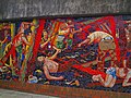
 Crumlin mural (geograph 1206348).jpg 640 × 480; 101 KB
-
 Crumlin mural (geograph 1206355).jpg 640 × 480; 110 KB
-
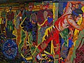
 Crumlin mural (geograph 1206375).jpg 640 × 480; 105 KB
-
 Crumlin mural.jpg 640 × 480; 116 KB
-
 Crumlin Navigation Colliery - Chimney, Powerhouse and North Winding House.jpg 1,280 × 960; 1.41 MB
-
 Crumlin Navigation Colliery - geograph.org.uk - 4037230.jpg 640 × 422; 85 KB
-
 Crumlin post office - geograph.org.uk - 2297548.jpg 640 × 512; 93 KB
-
 Crumlin RFC club and headquarters - geograph.org.uk - 2712499.jpg 640 × 399; 61 KB
-
 Crumlin Road permanently closed ahead - geograph.org.uk - 2751916.jpg 640 × 480; 105 KB
-

-
 Crumlin viaduct from Celynen North - geograph.org.uk - 3390008.jpg 640 × 480; 568 KB
-
 Crumlin Viaduct site geograph-3342868-by-Ben-Brooksbank.jpg 2,320 × 1,533; 4.44 MB
-
 Crumlin Viaduct.jpg 2,930 × 2,249; 1.73 MB
-
 Crumlin Workmen's Club and Institute - geograph.org.uk - 3179095.jpg 640 × 480; 64 KB
-
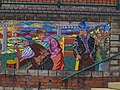
 Crumlin, Mural.jpg 640 × 477; 91 KB
-
 Culvert, Hafod-yr-ynys Road, Crumlin - geograph.org.uk - 5081558.jpg 5,179 × 3,451; 4.47 MB
-
 Cwm Nant Gwynt boundary sign detail - geograph.org.uk - 5220627.jpg 800 × 405; 47 KB
-
 Cwm Nant Gwynt name sign - geograph.org.uk - 5220954.jpg 800 × 593; 202 KB
-
 Cwm Nant Gwynt side road - geograph.org.uk - 5220738.jpg 800 × 570; 127 KB
-
 Damaged stile to footpath, Gelli - geograph.org.uk - 5316377.jpg 5,179 × 3,429; 4.19 MB
-
 Dark green lockup garages, Hafodyrynys - geograph.org.uk - 5647538.jpg 714 × 800; 120 KB
-
 Derelict brick hut, Mynydd Llwyd - geograph.org.uk - 6784748.jpg 5,184 × 3,456; 7.49 MB
-

-
 Derelict colliery, Crumlin - geograph.org.uk - 1157312.jpg 640 × 480; 75 KB
-
 Derelict historic farmhouse, Gelli - geograph.org.uk - 5316379.jpg 5,179 × 3,451; 6.02 MB
-

-
 Derelict Pen-y-Graig Farm - geograph.org.uk - 5214753.jpg 5,179 × 3,451; 6.62 MB
-
 Derelict stone building - geograph.org.uk - 6486493.jpg 5,184 × 3,456; 7.65 MB
-
 Descent towards Cwm Nant Gwynt - geograph.org.uk - 5234240.jpg 800 × 721; 151 KB
-

-

-
 Dilapidated stone wall - geograph.org.uk - 4988142.jpg 5,184 × 3,456; 7.15 MB
-

-
 Drought-affected shore, Pen-y-fan Pond - geograph.org.uk - 6498917.jpg 5,179 × 3,451; 5.77 MB
-
 Ducks on Pen-y-fan Pond - geograph.org.uk - 4326329.jpg 800 × 434; 101 KB
-

-

-
 Eastern boundary of Sofrydd - geograph.org.uk - 2482433.jpg 640 × 505; 101 KB
-
 Eastern end of Kendon Road, Crumlin - geograph.org.uk - 2751649.jpg 640 × 480; 85 KB
-

-
 Ebbw river, Aberbeeg - geograph.org.uk - 1932317.jpg 640 × 516; 145 KB
-
 Ebbw River, Aberbeeg - geograph.org.uk - 5823135.jpg 5,179 × 3,451; 5.26 MB
-
 Ebbw River, Station Road, Crumlin - geograph.org.uk - 4793208.jpg 5,179 × 3,451; 6.2 MB
-
 Ebbw River, under A467 bridge, Aberbeeg - geograph.org.uk - 4842517.jpg 5,179 × 3,451; 4.31 MB
-
 Ebbw Valley Railway, Crumlin - geograph.org.uk - 4793239.jpg 5,179 × 3,451; 4.88 MB
-
 Ebbw Valley Walk above Treowen - geograph.org.uk - 4779639.jpg 5,163 × 3,387; 5.11 MB
-
 Ebbw Valley Walk from Kendon Road, Kendon - geograph.org.uk - 4785845.jpg 5,043 × 3,361; 6.09 MB
-
 Ebbw Valley Walk from pond at Tir-hunt - geograph.org.uk - 5157339.jpg 5,184 × 3,456; 7.63 MB
-
 Ebbw Valley Walk near Load of Hay Lane - geograph.org.uk - 4715681.jpg 5,133 × 3,451; 4.89 MB
-
 Ebbw Valley Walk on minor road from Treowen - geograph.org.uk - 4779653.jpg 5,184 × 3,456; 7.32 MB
-
 Ebbw Valley Walk towards Tir hunt - geograph.org.uk - 5157243.jpg 5,179 × 3,451; 6.03 MB
-
 Ebbw Valley Walk, Load of Hay Lane - geograph.org.uk - 4715147.jpg 5,144 × 3,451; 5.06 MB
-
 Ebbw Valley Walk, Pen-y-fan-fach - geograph.org.uk - 5228263.jpg 5,179 × 3,451; 5.72 MB
-
 Ebbw Valley Walk, Pen-y-fan-fach Farm - geograph.org.uk - 5228656.jpg 5,184 × 3,456; 7.58 MB
-
 Ebbw Valley Walk, Ty-mawr - geograph.org.uk - 4648670.jpg 5,184 × 3,456; 7.32 MB
-
 Edge of Coed Llwyn-du - geograph.org.uk - 2021032.jpg 640 × 480; 94 KB
-

-
 Edge of Pen-y-fan Pond - geograph.org.uk - 2828662.jpg 640 × 480; 138 KB
-

-

-

-

-
 End of byway down from Pen-y-fan Pond - geograph.org.uk - 6485875.jpg 5,243 × 3,545; 5.15 MB
-

-

-
 End of the 20 zone, Trinant - geograph.org.uk - 5234341.jpg 800 × 558; 118 KB
-

-

-
 Entrance gate to Crumlin cricket ground - geograph.org.uk - 2299903.jpg 640 × 527; 117 KB
-

-
 Entrance to Brace's Bakery, Pen-y-fan - geograph.org.uk - 3986508.jpg 800 × 632; 144 KB
-
 Entrance to Coetir Graig Fawr Woodland, Aberbeeg - geograph.org.uk - 5051954.jpg 5,179 × 3,451; 5.98 MB
-

-
 Entry Sign -' Croespenmaen', Lon Maes Yr Haf, - geograph.org.uk - 4582224.jpg 2,516 × 1,558; 794 KB
-
 Fanhouse and Winding House, Crumlin Navigation Colliery - geograph.org.uk - 5539381.jpg 5,184 × 3,456; 7.03 MB
-
 Fanhouse, Crumlin Navigation Colliery - geograph.org.uk - 5540111.jpg 5,179 × 3,451; 4.82 MB
-
 Farm at Gelli - geograph.org.uk - 5730660.jpg 5,184 × 3,456; 6.38 MB
-
 Farm buildings near Pentrapeod - geograph.org.uk - 5236955.jpg 4,000 × 3,000; 4.98 MB
-
 Farm pond, Tir-hunt - geograph.org.uk - 5157303.jpg 5,179 × 3,451; 6.72 MB
-
 Farmyard, Lower Ton-y-Felin - geograph.org.uk - 4570939.jpg 3,072 × 2,304; 2.2 MB
-
 Felled hedgerow trees - geograph.org.uk - 5248030.jpg 5,179 × 3,451; 4.35 MB
-
 Felled hedgerow, Manmoel Road - geograph.org.uk - 5248102.jpg 5,179 × 3,451; 4.49 MB
-
 Fence by Ebbw Valley Walk near Tir-hunt - geograph.org.uk - 5157214.jpg 5,179 × 3,451; 5.03 MB
-

-
 Fern Close, Pen-y-fan - geograph.org.uk - 3986441.jpg 800 × 600; 131 KB
-
 Fflorens Road, Treowen - geograph.org.uk - 2299755.jpg 640 × 480; 59 KB
-
 Field alongside Kendon to Trinant road - geograph.org.uk - 4713430.jpg 5,179 × 3,429; 4.04 MB
-
 Field behind Pen-y-fan Industrial Estate - geograph.org.uk - 4694561.jpg 5,174 × 3,288; 4.83 MB
-
 Field footpath from Pen-y-fan-fach - geograph.org.uk - 5214725.jpg 5,179 × 3,451; 6.35 MB
-
 Field footpath going south to Pen-y-fan-fach - geograph.org.uk - 5214581.jpg 5,179 × 3,451; 5.65 MB
-
 Field footpath to Kendon Farm - geograph.org.uk - 4717867.jpg 5,096 × 3,451; 4.91 MB
-
 Field in winter, Pen-y-fan - geograph.org.uk - 4798974.jpg 5,179 × 3,451; 4.23 MB
-
 Field near Cefn-coch - geograph.org.uk - 4693872.jpg 5,069 × 3,387; 5.27 MB
-
 Field on Ebbw Valley Walk, near Treowen - geograph.org.uk - 5153132.jpg 5,179 × 3,451; 4.03 MB
-
 Field under transmission lines, Load of Hay Lane - geograph.org.uk - 4717833.jpg 5,128 × 3,451; 4.04 MB
-
 Field ^ fallen tree, near Croespenmaen - geograph.org.uk - 4954493.jpg 5,179 × 3,451; 5.49 MB
-
 Field, Load of Hay Lane - geograph.org.uk - 4715699.jpg 5,160 × 3,451; 4.77 MB
-
 Fly fishing in Pen-y-fan Pond - geograph.org.uk - 4326335.jpg 800 × 551; 139 KB


.svg)


_station_site_geograph-3341574-by-Ben-Brooksbank.jpg)


.jpg)
.jpg)
.jpg)


