Category:Croy, North Lanarkshire
Jump to navigation
Jump to search
village in North Lanarkshire, Scotland, UK | |||||
| Upload media | |||||
| Instance of | |||||
|---|---|---|---|---|---|
| Location |
| ||||
| Population |
| ||||
| Different from | |||||
 | |||||
English: Croy is a village in North Lanarkshire (previously in Dunbartonshire), Scotland. A former mining community, Croy is situated some 21 km from Glasgow and 60 km from Edinburgh on the main railway line between the two cities, with a frequent service to both. Croy station is also served by local trains between Glasgow and Stirling.
Nederlands: Croy is een dorp in Schotland, 21 kilometer ten oosten van Glasgow. De plaats ligt in North Lanarkshire, direct ten noorden van de new town Cumbernauld.
Subcategories
This category has the following 2 subcategories, out of 2 total.
C
- Croy Hill (24 F)
- Croy railway station (16 F)
Media in category "Croy, North Lanarkshire"
The following 32 files are in this category, out of 32 total.
-
Antonine Sports Hub.png 989 × 642; 1.02 MB
-
Barbegs Crescent, Croy - geograph.org.uk - 2796526.jpg 640 × 480; 99 KB
-
Barge on the Forth and Clyde canal - geograph.org.uk - 1509686.jpg 640 × 480; 85 KB
-
Cemex concrete plant - geograph.org.uk - 5105741.jpg 640 × 480; 168 KB
-
Cemex concrete plant - geograph.org.uk - 5105743.jpg 640 × 395; 141 KB
-
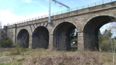
Croy Four Arches.png 930 × 523; 848 KB
-
Croy from the air (geograph 5670656).jpg 640 × 480; 240 KB
-
Croy from the air - geograph.org.uk - 4517280.jpg 640 × 480; 125 KB
-
Croy miners cottages.png 875 × 523; 633 KB
-
Croy Quarry from the air (geograph 5670645).jpg 640 × 480; 212 KB
-
Croy Viaduct Signpost.png 294 × 523; 301 KB
-
Entrance to Croy Quarry - geograph.org.uk - 934165.jpg 640 × 480; 77 KB
-
Field beside the "Military Way" - geograph.org.uk - 4882517.jpg 1,200 × 1,600; 412 KB
-
Floral Display in Croy - geograph.org.uk - 1459432.jpg 640 × 480; 115 KB
-
Holy Cross Church, Croy (01).png 677 × 523; 404 KB
-
Kirkintilloch or Kilsyth^ - geograph.org.uk - 934172.jpg 480 × 640; 106 KB
-
North Lanarkshire and the Kilsyth Hills (geograph 5847118).jpg 2,426 × 1,529; 1.8 MB
-
Old harbour on the Forth and Clyde - geograph.org.uk - 934197.jpg 640 × 480; 36 KB
-
Old Shaft, Auchinstrarry - geograph.org.uk - 1871259.jpg 820 × 615; 162 KB
-
Path by the Forth and Clyde Canal - geograph.org.uk - 1006319.jpg 640 × 480; 115 KB
-
Path near the Antonine Way - geograph.org.uk - 1006306.jpg 640 × 480; 131 KB
-
Picnic Site on Nethercroy - geograph.org.uk - 1454821.jpg 640 × 480; 80 KB
-
Pleasure craft sailing east - geograph.org.uk - 1586054.jpg 640 × 480; 77 KB
-
Reflected vessel - geograph.org.uk - 1579052.jpg 640 × 480; 62 KB
-
Remains of Nether Croy - geograph.org.uk - 1712229.jpg 1,024 × 768; 811 KB
-
Shrine 2.png 533 × 523; 566 KB
-
The Croy Tavern - geograph.org.uk - 1547065.jpg 640 × 480; 53 KB
-
The Military Way - geograph.org.uk - 2781998.jpg 480 × 640; 94 KB
-
Track from Croy to the canal - geograph.org.uk - 715228.jpg 640 × 480; 142 KB
-
Worked out quarry at Croy - geograph.org.uk - 1509615.jpg 640 × 480; 74 KB


