Category:Creu de terme del Pati (Tàrrega)
Jump to navigation
Jump to search
| Object location | | View all coordinates using: OpenStreetMap |
|---|
 | |||||
| Upload media | |||||
| Instance of | |||||
|---|---|---|---|---|---|
| Location | Tàrrega, Urgell, Ponent, Province of Lleida, Catalonia | ||||
| Street address |
| ||||
| Architectural style | |||||
| Heritage designation |
| ||||
| Elevation above sea level |
| ||||
 | |||||
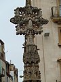
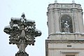
Català: Creu de terme del Pati a Tàrrega (Urgell)
This is a category about a building listed in the Catalan heritage register as Bé Cultural d'Interès Local (BCIL) under the reference IPA-29957. |
Media in category "Creu de terme del Pati (Tàrrega)"
The following 7 files are in this category, out of 7 total.
-
 139 Creu de terme del Pati, a la plaça Major.jpg 1,704 × 2,272; 1.44 MB
-
 149 Edifici de la Caixa i creu de terme.jpg 2,592 × 3,456; 952 KB
-
 150 Creu de terme del Pati.jpg 2,592 × 3,456; 1.18 MB
-
 Creu de terme del Pati, Tàrrega-1.JPG 3,000 × 4,000; 4.27 MB
-
 Creu de terme del Pati, Tàrrega-2.JPG 3,000 × 4,000; 3.98 MB
-
 Tarrega PM 096008 E.jpg 400 × 600; 222 KB
-
 Tarrega12453snow.jpg 1,000 × 666; 57 KB


