Category:Created with GMT
Jump to navigation
Jump to search
Subcategories
This category has the following 2 subcategories, out of 2 total.
G
- GFDL-GMT (2 P, 1278 F)
Media in category "Created with GMT"
The following 196 files are in this category, out of 196 total.
-
-

-
-
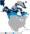
 American Three-toed Woodpecker Picoides dorsalis distribution map 2.png 756 × 800; 129 KB
-
 American Three-toed Woodpecker Picoides dorsalis distribution map.png 756 × 800; 128 KB
-
 Ancient Roman time keeping sun path hora.png 1,305 × 480; 448 KB
-
 Bearing and azimuth along the geodesic.png 632 × 800; 87 KB
-
 Bighorn Sheep Ovis canadensis distribution map topo 2.png 563 × 800; 474 KB
-
 Bighorn Sheep Ovis canadensis distribution map topo.png 563 × 800; 468 KB
-
 Bighorn Sheep Ovis canadensis distribution map.png 563 × 800; 101 KB
-
 Black Grouse Lyrurus tetrix distribution in Europe map.png 800 × 787; 129 KB
-
 Black Grouse Lyrurus tetrix distribution map.png 800 × 398; 71 KB
-
 Black-tailed Prairie Dog Cynomys ludovicianus distribution map 2.png 800 × 795; 130 KB
-
 Black-tailed Prairie Dog Cynomys ludovicianus distribution map.png 785 × 800; 78 KB
-
 Blue Parrotfish Scarus coeruleus distribution map.png 800 × 576; 86 KB
-
 Bobak Marmot Marmota bobak distribution map.png 800 × 723; 116 KB
-
 Bobcat Lynx rufus distribution map.png 704 × 800; 124 KB
-
 Borneo-H.jpg 1,848 × 1,880; 576 KB
-
 BrnBld LaptevTopo.pdf 760 × 754; 48 KB
-
 Brown Lemming Lemmus trimucronatus distribution map.png 800 × 443; 92 KB
-
 Bushbuck Tragelaphus scriptus distribution map.png 756 × 800; 95 KB
-
-

-

-
 Canada relief map 2.svg 1,114 × 942; 1.47 MB
-
 Caribbean Sea Gulf of Mexico shaded relief bathymetry land map 2.png 1,024 × 664; 1.12 MB
-
 Caribbean Sea Gulf of Mexico shaded relief bathymetry land map.png 1,024 × 664; 1.1 MB
-
 Common Dab Limanda limanda distribution map.png 609 × 800; 110 KB
-
 Cornerrise-some-names.png 550 × 323; 119 KB
-
 Cornerrise.png 3,509 × 2,480; 190 KB
-
 Croatia relief map.png 731 × 707; 882 KB
-
 Denmarkmap - 2.png 995 × 811; 29 KB
-
 Denmarkmap.png 926 × 758; 67 KB
-
 East African oryx Oryx beisa distribution map 2.png 568 × 889; 739 KB
-
 East African oryx Oryx beisa distribution map.png 775 × 924; 108 KB
-
 Equidistant Cylindrical Projection Earth.png 497 × 257; 7 KB
-

-
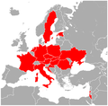
 Europe position map 4.svg 452 × 389; 401 KB
-
 Europe relief map 4.png 753 × 649; 910 KB
-
 Gemsbok Oryx gazella distribution map.png 800 × 795; 88 KB
-
 Gerenuk Litocranius walleri distribution map.png 770 × 800; 90 KB
-
 Giant pika Ochotona whartoni fossil distribution.gif 610 × 610; 38 KB
-
 GMT France with altitudes.pdf 1,181 × 1,181; 145 KB
-
 GMT globe.png 320 × 160; 88 KB
-
 Great Lakes bathymetry map 2.png 1,024 × 731; 943 KB
-
 Great Lakes bathymetry map.png 1,024 × 731; 1.34 MB
-
 Greece 34 43 17 30 blank map.png 1,197 × 1,056; 107 KB
-
 Grey Seal Halichoerus grypus distribution map.png 788 × 400; 80 KB
-
 Gunnison Grouse Centrocercus minimus distribution map 2.png 800 × 479; 427 KB
-
 Gunnison Grouse Centrocercus minimus distribution map 3.png 800 × 479; 809 KB
-
 Gunnison Grouse Centrocercus minimus distribution map.png 800 × 479; 44 KB
-
 Gunnison's Prairie Dog Cynomys gunnisoni distribution map.png 785 × 800; 75 KB
-
 Harbour Porpoise Phocoena phocoena distribution map.png 800 × 321; 72 KB
-
 Hoary Marmot Marmota caligata distribution map 2.png 800 × 560; 92 KB
-
 Hoary Marmot Marmota caligata distribution map.png 800 × 761; 133 KB
-
 Hwasong-12 range 3700-6000km.png 434 × 434; 135 KB
-
 Jack-knifefish Equetus lanceolatus distribution map.png 800 × 696; 104 KB
-
 Kanał Bródnowski - mapa.gif 250 × 372; 18 KB
-
 Kanał Wawerski - mapa.gif 250 × 223; 14 KB
-
 Kanał Żerański - mapa.gif 250 × 372; 17 KB
-
 Klipspringer Oreotragus oreotragus distribution map.png 701 × 800; 92 KB
-
 Kępa Wieloryb - mapa.png 420 × 160; 30 KB
-
 Lake Erie and Lake Saint Clair bathymetry map 2.png 1,024 × 684; 512 KB
-
 Lake Erie and Lake Saint Clair bathymetry map.png 1,024 × 684; 766 KB
-
 Lake Huron bathymetry map 2.png 936 × 1,024; 878 KB
-
 Lake Huron bathymetry map.png 936 × 1,024; 1.35 MB
-
 Lake Michigan bathymetry map 2.png 597 × 1,024; 600 KB
-
 Lake Michigan bathymetry map.png 597 × 1,024; 948 KB
-
 Lake Ontario bathymetry map 2.png 1,024 × 656; 470 KB
-
 Lake Ontario bathymetry map.png 1,024 × 656; 750 KB
-
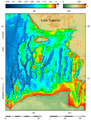
 Lake Superior bathymetry map 2.png 1,024 × 636; 699 KB
-
 Lake Superior bathymetry map, deepest point 2.png 700 × 855; 383 KB
-
 Lake Superior bathymetry map, deepest point, trenches 2.png 1,024 × 1,348; 940 KB
-
 Lake Superior bathymetry map, deepest point, trenches.png 1,024 × 1,348; 1.36 MB
-
 Lake Superior bathymetry map, deepest point.png 895 × 1,539; 587 KB
-
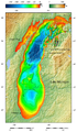
 Lake Superior bathymetry map.png 1,024 × 636; 1,014 KB
-
 Lesser Egyptian Jerboa Jaculus jaculus distribution map 2.png 800 × 575; 96 KB
-
 Lesser Egyptian Jerboa Jaculus jaculus distribution map.png 707 × 800; 105 KB
-

-
 Lesser Prairie Chicken Tympanuchus pallidicinctus distribution map 3.png 704 × 800; 1.02 MB
-
 Lesser Prairie Chicken Tympanuchus pallidicinctus distribution map 4.png 704 × 800; 1.05 MB
-
 Lesser Prairie Chicken Tympanuchus pallidicinctus distribution map.png 800 × 763; 124 KB
-
 Location of Locris.png 301 × 301; 51 KB
-
 Longnose Butterflyfish Forcipiger longirostris distribution map.png 800 × 354; 63 KB
-
 Longspined Bullhead Taurulus bubalis distribution map.png 564 × 800; 107 KB
-
 Map projection-Eckert VI.png 1,001 × 502; 56 KB
-
-
 Nelson's Collared Lemming Dicrostonyx nelsoni distribution map 2.png 800 × 532; 59 KB
-
 Nelson's Collared Lemming Dicrostonyx nelsoni distribution map.png 800 × 761; 123 KB
-

-
 Northern Bog Lemming Synaptomys borealis distribution map.png 800 × 761; 125 KB
-
 Northern Collared Lemming Dicrostonyx groenlandicus distribution map.png 800 × 665; 125 KB
-
 Northern flying squirrel Glaucomys sabrinus distribution map.png 704 × 800; 47 KB
-
 Norway Lemming Lemmus lemmus distribution map.png 800 × 787; 121 KB
-
 Norway Spruce Picea abies distribution in Poland map.png 765 × 800; 74 KB
-
 Norway Spruce Picea abies distribution map.png 708 × 800; 134 KB
-
-

-
 Oregon Spotted Frog Rana pretiosa distribution map 2.png 700 × 800; 580 KB
-
 Oregon Spotted Frog Rana pretiosa distribution map 3.png 700 × 800; 1.03 MB
-
 Oregon Spotted Frog Rana pretiosa distribution map.png 700 × 800; 91 KB
-
 Patagonian Mara Dolichotis patagonum distribution map.png 574 × 800; 74 KB
-
 Pika Ochotona sp. fossil distribution 2.png 720 × 224; 59 KB
-
 Pika Ochotona sp. fossil distribution.gif 590 × 1,180; 86 KB
-
 Pika Prolagus oeningensis fossil distribution map.png 800 × 637; 106 KB
-
 Pika Prolagus sp. fossil distribution map.png 800 × 567; 109 KB
-
 Potok Służewiecki - mapa 2.png 420 × 205; 34 KB
-
 Potok Służewiecki - mapa.gif 250 × 260; 16 KB
-
 Pristine mustached bat Pteronotus pristinus fossil distribution.gif 420 × 234; 12 KB
-

-
 Prolagus oeningensis map2.png 800 × 637; 109 KB
-
 Red-eyed Treefrog Agalychnis callidryas distribution map 2.png 800 × 611; 86 KB
-
 Red-eyed Treefrog Agalychnis callidryas distribution map 3.png 800 × 611; 226 KB
-
 Red-eyed Treefrog Agalychnis callidryas distribution map.png 800 × 674; 95 KB
-
 Redtail Butterflyfish Chaetodon collare distribution map.png 800 × 474; 72 KB
-
 Relief map of Bahamas.png 780 × 562; 288 KB
-
 Relief Map of Baltic Sea.png 869 × 1,039; 1.14 MB
-
 Relief Map of Borneo.png 800 × 867; 747 KB
-
 Relief map of California.png 681 × 780; 647 KB
-
 Relief map of Canada.png 1,084 × 920; 1.82 MB
-
 Relief Map of Falkland Islands.png 1,134 × 923; 528 KB
-
 Relief map of Italy Calabria.png 794 × 878; 716 KB
-
 Relief map of Italy Sicily.png 645 × 705; 284 KB
-
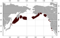
 Relief Map of Kurily.png 882 × 946; 530 KB
-
 Relief map of Lesser Antilles.png 673 × 578; 345 KB
-
 Relief map of Northern California.png 654 × 489; 454 KB
-
 Relief Map of Northern Ireland.png 806 × 685; 689 KB
-
 Relief map of Solomon Islands.png 945 × 543; 407 KB
-
 Relief Map of Tasmania.png 780 × 957; 494 KB
-
 Relief map of Texas.png 1,000 × 989; 1.28 MB
-
 Relief map of U.S., Nevada Augusta Mountains.png 882 × 1,297; 1.35 MB
-
 Relief map of U.S., Nevada.png 882 × 1,297; 1.12 MB
-
 Relief map of USA Alaska.png 776 × 580; 693 KB
-
 Relief map of USA Massachusetts.png 700 × 478; 487 KB
-
 Relief map of USA Michigan.png 1,066 × 1,200; 1,000 KB
-
 Relief map of USA Nevada Amargosa Range.png 882 × 1,297; 1.35 MB
-
 Relief map of USA Nevada Bodie Mountains.png 882 × 1,297; 1.35 MB
-
 Relief map of USA Nevada Jarbidge Mountains.png 882 × 1,297; 1.35 MB
-
 Relief map of USA Nevada Ruby Mountains.png 882 × 1,297; 1.35 MB
-
 Relief map of USA Nevada Santa Renia Mountains.png 882 × 1,297; 1.35 MB
-
 Relief map of USA Nevada Schell Creek Range.png 882 × 1,297; 1.35 MB
-
 Relief map of USA Nevada Snake Range.png 882 × 1,297; 1.36 MB
-
 Relief map of USA Nevada Spring Mountains.png 882 × 1,297; 1.35 MB
-
 Relief map of USA Nevada Toiyabe Range.png 882 × 1,297; 1.35 MB
-
 Relief map of USA Nevada Toquima Range.png 882 × 1,297; 1.36 MB
-
 Relief map USA Connecticut.png 800 × 678; 690 KB
-
 Relief Yakutia.png 923 × 855; 1.78 MB
-
 Rhacophorus maximus distribution map 2.png 800 × 706; 727 KB
-
 Rhacophorus maximus distribution map.png 800 × 706; 73 KB
-

-
 Roan Antelope Hippotragus equinus distribution map.png 748 × 800; 94 KB
-
 Rock Ptarmigan Lagopus muta distribution in Europe map.png 800 × 787; 130 KB
-
 Rock Ptarmigan Lagopus muta distribution in North America map.png 710 × 800; 132 KB
-
 Rock Ptarmigan Lagopus muta distribution map.png 800 × 300; 72 KB
-
 Saddle Butterflyfish Chaetodon ephippium distribution map.png 800 × 443; 67 KB
-

-
 Sage Grouse Centrocercus urophasianus distribution map 2.png 701 × 800; 84 KB
-
 Sage Grouse Centrocercus urophasianus distribution map.png 800 × 761; 125 KB
-
 Sea Otter Enhydra lutris distribution map 2.png 800 × 508; 55 KB
-
 Sea Otter Enhydra lutris distribution map.png 800 × 319; 65 KB
-
 Sevastopol-relief.png 451 × 511; 345 KB
-
 Shenandoah Salamander Plethodon shenandoah distribution map 2.png 800 × 388; 300 KB
-
 Shenandoah Salamander Plethodon shenandoah distribution map 3.png 800 × 389; 570 KB
-
 Shenandoah Salamander Plethodon shenandoah distribution map.png 800 × 388; 58 KB
-
 Siberian Brown Lemming Lemmus sibiricus distribution map.png 800 × 556; 104 KB
-
 Siberian Chipmunk Tamias sibiricus distribution map.png 800 × 444; 79 KB
-
 Slovenia relief map.png 581 × 430; 451 KB
-
 South African springhare Pedetes capensis distribution map.png 785 × 800; 90 KB
-
 Southern Bog Lemming Synaptomys cooperi distribution map.png 800 × 761; 128 KB
-
 Southern flying squirrel Glaucomys volans distribution map.png 704 × 800; 125 KB
-
 Southern Hagfish Myxine australis distribution map.png 592 × 800; 77 KB
-
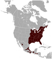
 Spotted (Lowland) paca Cuniculus paca distribution map.png 639 × 800; 85 KB
-
 Starry sturgeon Acipenser stellatus distribution map.png 748 × 800; 168 KB
-
 Suriname Toad Pipa pipa distribution map.png 560 × 800; 100 KB
-
 Syrian Woodpecker Dendrocopos syriacus distribution map.png 800 × 719; 127 KB
-
 Tibet and surrounding areas topographic map 2.png 3,000 × 1,873; 9.1 MB
-
 Tibet and surrounding areas topographic map 3.png 3,000 × 1,873; 8.97 MB
-
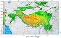 Tibet and surrounding areas topographic map.png 3,000 × 1,873; 7.35 MB
-

-
 Warszawa geomorfologia Wisła taras zalewowy mapa.gif 770 × 800; 60 KB
-
 Western Capercaillie Tetrao urogallus distribution in Europe map.png 800 × 770; 131 KB
-
 Western Capercaillie Tetrao urogallus distribution map.png 800 × 398; 71 KB
-

-
 White-backed Woodpecker Dendrocopos leucotos distribution map.png 800 × 451; 80 KB
-
 White-tailed Prairie Dog Cynomys leucurus distribution map.png 785 × 800; 75 KB
-
 White-tailed Ptarmigan Lagopus leucura distribution map.png 800 × 753; 135 KB
-
 Wild Cat Felis silvestris distribution in Europe map.png 800 × 652; 130 KB
-
 Wild Cat Felis silvestris distribution map.png 800 × 607; 117 KB
-
 Willow Ptarmigan Lagopus lagopus distribution in Europe map.png 800 × 842; 129 KB
-
 Willow Ptarmigan Lagopus lagopus distribution in North America map.png 710 × 800; 121 KB
-
 Willow Ptarmigan Lagopus lagopus distribution map.png 800 × 300; 67 KB
-
 Yellow-bellied Marmot Marmota flaviventris distribution map 2.png 795 × 800; 85 KB
-
 Yellow-bellied Marmot Marmota flaviventris distribution map.png 800 × 761; 127 KB
-
 Yellow-bellied Sea Snake Pelamis platura distribution map.png 800 × 351; 72 KB
-
 Zakole Wawerskie - mapa.png 320 × 439; 51 KB
-
 Łacha Siekierkowska - mapa.gif 320 × 331; 12 KB
_Three-toed_Woodpecker_Picoides_tridactylus_distribution_in_Eurasia_map.png)
_Three-toed_Woodpecker_Picoides_tridactylus_distribution_in_Europe_map.png)


_paca_Cuniculus_paca_distribution_map.png)


