Category:Cowshed of the former farm in Bażanowice
Jump to navigation
Jump to search
| Object location | | View all coordinates using: OpenStreetMap |
|---|
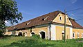
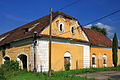
Polski: Obora dawnego folwarku, 1839 r. - Bażanowice, ul. Folwarczna
historic building in Bażanowice, Silesian Voivodeship, Poland  | |||||
| Upload media | |||||
| Instance of | |||||
|---|---|---|---|---|---|
| Part of |
| ||||
| Made from material | |||||
| Location | Bażanowice, Gmina Goleszów, Cieszyn County, Silesian Voivodeship, Poland | ||||
| Heritage designation |
| ||||
| Inception |
| ||||
| Area |
| ||||
| Elevation above sea level |
| ||||
 | |||||
Media in category "Cowshed of the former farm in Bażanowice"
The following 13 files are in this category, out of 13 total.
-
 2018 Powiat cieszyński, Bażanowice, Stary folwark 01.jpg 4,860 × 3,240; 9.22 MB
-
 2018 Powiat cieszyński, Bażanowice, Stary folwark 02.jpg 4,849 × 3,233; 9.85 MB
-
 2018 Powiat cieszyński, Bażanowice, Stary folwark 03.jpg 4,925 × 3,283; 9.91 MB
-
 2018 Powiat cieszyński, Bażanowice, Stary folwark 04.jpg 4,892 × 3,261; 9.9 MB
-
 Dawny folwark, Bażanowice, okres Těšín, Polsko 01.jpg 9,248 × 6,944; 43.43 MB
-
 Dawny folwark, Bażanowice, okres Těšín, Polsko 02.jpg 9,248 × 6,944; 21.45 MB
-
 Dawny folwark, Bażanowice, okres Těšín, Polsko 03.jpg 9,248 × 6,944; 35.95 MB
-
 Dwór w Bażanowicach 1.JPG 4,368 × 2,912; 11.21 MB
-
 Dwór w Bażanowicach 2.JPG 4,270 × 2,402; 12.15 MB
-
 Dwór w Bażanowicach 3.JPG 4,622 × 3,080; 11.93 MB
-
 Dwór w Bażanowicach 4.JPG 4,180 × 2,787; 9.37 MB
-
 Obora w Bażanowicach.JPG 3,072 × 1,728; 2.81 MB
-
 POL Bażanowice Zamek.JPG 3,648 × 2,100; 2.39 MB


