Category:Cowhouse in Roztoki
Jump to navigation
Jump to search
| Object location | | View all coordinates using: OpenStreetMap |
|---|
 | |||||
| Upload media | |||||
| Instance of | |||||
|---|---|---|---|---|---|
| Location | Roztoki, Lower Silesian Voivodeship, Gmina Międzylesie, Kłodzko County, Lower Silesian Voivodeship, Poland | ||||
| Heritage designation |
| ||||
 | |||||
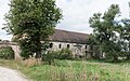
Polski: Roztoki 18 - obora
Media in category "Cowhouse in Roztoki"
The following 6 files are in this category, out of 6 total.
-
 2017 Obora w Roztokach 1.jpg 4,330 × 2,338; 7.83 MB
-
 2017 Obora w Roztokach 2.jpg 4,278 × 2,680; 9.83 MB
-
 2017 Obora w Roztokach 3.jpg 4,211 × 2,716; 8.84 MB
-
 2018 Obora w Roztokach 1.jpg 5,193 × 3,093; 12.5 MB
-
 2018 Obora w Roztokach 2.jpg 4,714 × 3,014; 11.31 MB
-
 2018 Obora w Roztokach 3.jpg 5,044 × 2,784; 12.25 MB


