Category:County maps of UK parliamentary constituencies 1885-1918
Jump to navigation
Jump to search
County maps of UK parliamentary constituencies created by the Redistribution of Seats Act 1885
Media in category "County maps of UK parliamentary constituencies 1885-1918"
The following 12 files are in this category, out of 12 total.
-
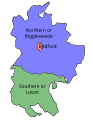 Bedfordshire1885.svg 1,236 × 1,598; 629 KB
-
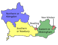 Berkshire1885.svg 1,558 × 1,204; 636 KB
-
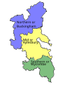 Buckinghamshire1885.svg 1,233 × 1,595; 736 KB
-
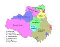
 Cheshire1885.svg 2,531 × 1,790; 1.44 MB
-
 Durham1885.svg 814 × 630; 1.41 MB
-
 Essex1885.svg 1,570 × 1,214; 1 MB
-
 Hertfordshire1885.svg 1,511 × 1,168; 632 KB
-
 Huntingdonshire1885.svg 1,594 × 2,062; 513 KB
-
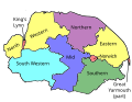 Norfolk1885.svg 1,444 × 1,116; 746 KB
-
 Northumberland1885.svg 563 × 760; 1.02 MB
-
 Oxfordshire1885.svg 1,180 × 1,526; 586 KB
-
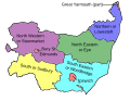 Suffolk1885.svg 1,605 × 1,240; 710 KB


