Category:Cosheston
Jump to navigation
Jump to search
village and community in Pembrokeshire, Wales, UK  Eglwys plwyf Cosheston  | |||||
| Upload media | |||||
| Instance of | |||||
|---|---|---|---|---|---|
| Location | Pembrokeshire, Wales | ||||
 | |||||
Cymraeg: Pentref, plwyf a chymuned yn ne Sir Benfro yw Cosheston. Nid ymddengys fod enw Cymraeg iddo. Saif i'r gogledd-ddwyrain o dref Penfro a ger Cilfach Cosheston neu Cosheston Pill, sy'n arwain i mewn i Afon Cleddau.
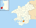
English: Cosheston is a village and parish in Pembrokeshire, Wales. It is situated on an inlet of the Daugleddau estuary, 3 km north-east of Pembroke. The northern part of the parish is in the Pembrokeshire Coast National Park. Together with the parishes of Upton and Nash, it constitutes the community of Cosheston, which had a population of 713 in 2001. With the community of Lamphey, it makes up the Pembrokeshire ward of Lamphey.
Subcategories
This category has the following 2 subcategories, out of 2 total.
S
- St Mary's Church, Lower Nash (33 F)
- St Michael's Church, Cosheston (14 F)
Media in category "Cosheston"
The following 96 files are in this category, out of 96 total.
-
 2010 Wales Pembrokeshire Community Cosheston map.svg 512 × 393; 1,018 KB
-
 2024 Wales Pembrokeshire Community Cosheston map.svg 512 × 393; 1.19 MB
-
 A4075 - geograph.org.uk - 3719293.jpg 640 × 430; 72 KB
-
 A4075 approaching the A477 - geograph.org.uk - 6303244.jpg 800 × 547; 144 KB
-
 A4075 towards the A477 - geograph.org.uk - 6303236.jpg 800 × 600; 159 KB
-
 A4075 towards the A477 - geograph.org.uk - 6303241.jpg 800 × 600; 89 KB
-
 A4075, Mutton Hill - geograph.org.uk - 3719298.jpg 640 × 430; 59 KB
-
 A477 - geograph.org.uk - 2600360.jpg 640 × 480; 165 KB
-
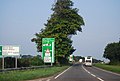
 A477 Approaching Pembroke Dock - geograph.org.uk - 1416428.jpg 640 × 480; 181 KB
-
 A477 near junction with A4975 - geograph.org.uk - 3719286.jpg 640 × 430; 63 KB
-
 A477 Near The A4075 Junction - geograph.org.uk - 1415281.jpg 640 × 480; 63 KB
-
 A477 towards Milton - geograph.org.uk - 6303246.jpg 800 × 600; 117 KB
-
 Access track to Folly - geograph.org.uk - 5162311.jpg 4,000 × 3,000; 2.74 MB
-
 Blackberry Lane - geograph.org.uk - 6303247.jpg 800 × 600; 166 KB
-
 Brewery Inn, Cosheston - geograph.org.uk - 5804872.jpg 1,280 × 960; 358 KB
-
 Cosheston Bridge - geograph.org.uk - 874174.jpg 640 × 404; 77 KB
-
 Cosheston Bridge area - award pillar - geograph.org.uk - 4493150.jpg 2,576 × 1,932; 1.18 MB
-
 Cosheston Bridge area - geograph.org.uk - 4493143.jpg 2,576 × 1,932; 1.25 MB
-
 Cosheston Pill at low tide - geograph.org.uk - 575231.jpg 640 × 480; 113 KB
-
 Cosheston Pill in the evening - geograph.org.uk - 874169.jpg 640 × 480; 59 KB
-
 Cosheston Point - geograph.org.uk - 848120.jpg 640 × 480; 59 KB
-
 Cosheston School - geograph.org.uk - 218154.jpg 640 × 480; 88 KB
-
 Country road near Winter Hall - geograph.org.uk - 2607531.jpg 1,024 × 680; 303 KB
-
 Entering Penny Bridge, A4075 - geograph.org.uk - 3719303.jpg 640 × 430; 72 KB
-
 Estuary from Cosheston Bridge area - geograph.org.uk - 4493155.jpg 2,576 × 1,932; 1.28 MB
-
 Estuary from Cosheston Bridge area - geograph.org.uk - 4493159.jpg 2,576 × 1,932; 1.24 MB
-
 Field entrance off the A4075 - geograph.org.uk - 6303240.jpg 800 × 600; 84 KB
-
 Fields near the Old Rectory - geograph.org.uk - 6303238.jpg 800 × 600; 90 KB
-
 Grass field and bungalow, Nash - geograph.org.uk - 5826726.jpg 1,024 × 768; 159 KB
-
 Grazing, Ridge Croft - geograph.org.uk - 6303092.jpg 800 × 600; 126 KB
-
 Green pastures near Mount Pleasant - geograph.org.uk - 5161782.jpg 3,847 × 2,110; 1.58 MB
-
 Hay field at Nash - geograph.org.uk - 5809079.jpg 1,024 × 768; 222 KB
-
 Houses at Jenkins Point - geograph.org.uk - 4314754.jpg 1,600 × 1,067; 259 KB
-
 Jenkins Point - geograph.org.uk - 3621844.jpg 1,224 × 918; 498 KB
-
 Lane through trees from Jenkins Point Cosheston - geograph.org.uk - 4491061.jpg 2,576 × 1,932; 1.09 MB
-
 Lane to Nash Church - geograph.org.uk - 5096522.jpg 2,576 × 1,932; 1.23 MB
-
 Lime Kiln, Cosheston - geograph.org.uk - 4491018.jpg 2,576 × 1,932; 1.08 MB
-
 Lime Kiln, Cosheston - geograph.org.uk - 4491022.jpg 2,576 × 1,932; 1.09 MB
-
 Little Mayeston - geograph.org.uk - 874165.jpg 640 × 480; 81 KB
-
 Lower Nash Farm - geograph.org.uk - 5826722.jpg 1,024 × 768; 195 KB
-
 Mill Bay - geograph.org.uk - 5162283.jpg 4,000 × 3,000; 2.79 MB
-
 Mill Bay through the trees - geograph.org.uk - 5162296.jpg 3,400 × 2,379; 1.64 MB
-
 Minor road approaching Ridge Croft - geograph.org.uk - 6303098.jpg 800 × 600; 99 KB
-
 Minor road towards Mutton Hill - geograph.org.uk - 6303234.jpg 800 × 529; 153 KB
-
 Mount Pleasant Cross - postbox - geograph.org.uk - 1025387.jpg 640 × 480; 93 KB
-
 Nash Lodge - geograph.org.uk - 6303243.jpg 640 × 445; 60 KB
-
 Old Milestone by the A477, Cosheston - geograph.org.uk - 6047892.jpg 600 × 800; 153 KB
-

-

-
 Old Pump north of Cosheston - geograph.org.uk - 4491032.jpg 2,576 × 1,932; 1.17 MB
-
 Old Pump north of Cosheston - geograph.org.uk - 4491035.jpg 2,576 × 1,932; 1.14 MB
-
 Old Pump north of Cosheston - geograph.org.uk - 4491040.jpg 2,576 × 1,932; 1.16 MB
-
 Old Pump north of Cosheston - geograph.org.uk - 4491044.jpg 2,576 × 1,932; 1.18 MB
-
 Old Pump north of Cosheston - geograph.org.uk - 4491050.jpg 2,576 × 1,932; 1.11 MB
-
 Old Pump north of Cosheston - geograph.org.uk - 4491053.jpg 2,576 × 1,932; 1.11 MB
-
 Old Pump, Cosheston - detail - geograph.org.uk - 4615353.jpg 2,576 × 1,932; 1.25 MB
-
 Old Pump, Cosheston - geograph.org.uk - 4615351.jpg 2,576 × 1,932; 1.17 MB
-
 Old Pump, Cosheston - geograph.org.uk - 4615354.jpg 2,576 × 1,932; 1.2 MB
-
 Ordnance Survey Cut Mark - geograph.org.uk - 4723175.jpg 480 × 640; 95 KB
-
 Ordnance Survey Cut Mark - geograph.org.uk - 4723181.jpg 640 × 480; 103 KB
-
 Ordnance Survey Cut Mark - geograph.org.uk - 4723184.jpg 640 × 480; 137 KB
-
 Ordnance Survey Cut Mark - geograph.org.uk - 5339138.jpg 640 × 423; 123 KB
-
 Ordnance Survey Cut Mark - geograph.org.uk - 5339144.jpg 640 × 408; 112 KB
-
 Ordnance Survey Cut Mark - geograph.org.uk - 5339148.jpg 640 × 448; 98 KB
-
 Ordnance Survey Pivot - geograph.org.uk - 4733667.jpg 480 × 640; 100 KB
-
 Path across field near Nash Church - geograph.org.uk - 5096564.jpg 2,576 × 1,932; 1.24 MB
-
 Phillip's Lane - geograph.org.uk - 2607495.jpg 1,024 × 680; 256 KB
-
 Pond and derelict buildings at Lower Nash Farm - geograph.org.uk - 5819616.jpg 1,024 × 768; 328 KB
-
 Road to Upper Nash - geograph.org.uk - 2607526.jpg 1,024 × 680; 249 KB
-
 Road to Upper Nash - geograph.org.uk - 2607535.jpg 1,024 × 680; 176 KB
-
 Sheep grazing, Mutton Hill - geograph.org.uk - 6303099.jpg 640 × 480; 59 KB
-
 Shoreline at Jenkins Point - geograph.org.uk - 5161797.jpg 3,000 × 4,000; 2.84 MB
-
 St. Mary's church, Nash - geograph.org.uk - 5826718.jpg 1,024 × 768; 297 KB
-
 The Brewery Inn, Cosheston - geograph.org.uk - 5161757.jpg 4,000 × 3,000; 2.67 MB
-
 The church and churchyard at Nash - geograph.org.uk - 5819573.jpg 1,024 × 768; 260 KB
-
 The lane to Mount Pleasant - geograph.org.uk - 1025386.jpg 640 × 480; 121 KB
-
 The old chemical works at Whalecombe - geograph.org.uk - 5170440.jpg 4,000 × 3,000; 3.55 MB
-
 Track to Cosheston - geograph.org.uk - 5162316.jpg 3,000 × 4,000; 3.52 MB
-
 Track to Upton - geograph.org.uk - 1025392.jpg 640 × 480; 83 KB
-
 Track to Upton Farm - geograph.org.uk - 5161765.jpg 3,000 × 4,000; 3.14 MB
-
 Upton Castle gardens - geograph.org.uk - 67380.jpg 640 × 480; 206 KB
-
 View of Haven from north of Cosheston - geograph.org.uk - 4491065.jpg 2,576 × 1,932; 1.22 MB
-

-
 Woodland path near Bank Farm - geograph.org.uk - 5161788.jpg 3,000 × 4,000; 3.37 MB
-

-
 Cosheston Pill from Cosheston Bridge - geograph.org.uk - 218206.jpg 640 × 480; 77 KB
-
 Derelict barn in Cosheston Hall park - geograph.org.uk - 575237.jpg 640 × 480; 95 KB
-
 Farmland and monument near Upper Nash - geograph.org.uk - 575229.jpg 640 × 480; 93 KB
-
 Lawrenny Quay - geograph.org.uk - 393179.jpg 640 × 480; 73 KB
-
 Little Mayeston - geograph.org.uk - 575612.jpg 640 × 480; 77 KB
-
 Millbay - geograph.org.uk - 427484.jpg 640 × 482; 88 KB
-
 Millbay with tide in - geograph.org.uk - 427486.jpg 640 × 482; 67 KB
-
 New road junction - geograph.org.uk - 226230.jpg 640 × 480; 79 KB
-
 Paskeston Lodge - geograph.org.uk - 218152.jpg 640 × 480; 96 KB
-

-


