Category:Copiapo Basin
Jump to navigation
Jump to search
drainage basin of Copiapo River and tributaries | |||||
| Upload media | |||||
| Instance of | |||||
|---|---|---|---|---|---|
| Named after | |||||
| Location |
| ||||
| Drainage basin | |||||
| |||||
Subcategories
This category has the following 2 subcategories, out of 2 total.
C
- Copiapó River (27 F)
P
- Pulido River (1 F)
Media in category "Copiapo Basin"
The following 19 files are in this category, out of 19 total.
-
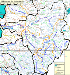
034-atlasagro.png 923 × 1,012; 944 KB
-
05-taltal-chañaral.jpg 5,551 × 3,378; 3.3 MB
-
Brecha-hidrica.svg 697 × 469; 86 KB
-
Copiapo (4321111050).jpg 2,816 × 2,112; 1.51 MB
-
Copiapo-unifilar.svg 1,272 × 1,064; 30 KB
-
HumedalRioCopiapo1.jpg 4,608 × 3,456; 3.57 MB
-
HumedalRioCopiapo2.jpg 4,608 × 3,456; 3.3 MB
-
HumedalRioCopiapo3.jpg 4,608 × 3,456; 3.35 MB
-
HumedalRioCopiapo4.jpg 4,608 × 3,456; 3.3 MB
-
HumedalRioCopiapo5.jpg 4,000 × 3,000; 4.64 MB
-
HumedalRioCopiapo6.jpg 4,000 × 3,000; 4.12 MB
-
HumedalRioCopiapo7.jpg 3,264 × 2,448; 3.33 MB
-
HumedalRioCopiapo8.jpg 3,264 × 2,448; 3.04 MB
-
HumedalRioCopiapo9.jpg 4,000 × 3,000; 5.2 MB
-
Inundación en Paipote.png 603 × 325; 296 KB
-
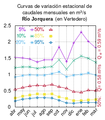
Jorquera-en-vertedero.png 280 × 320; 26 KB
-
Manflas-en-vertedero.png 280 × 320; 27 KB
-
Tierra Amarilla, III Región, Chile - panoramio (1).jpg 1,000 × 750; 580 KB
-
Txu-pclmaps-oclc-22834566 q-26b.jpg 9,000 × 6,535; 9.95 MB


