Category:Conjunt del centre antic de Rubí
Jump to navigation
Jump to search
| Object location | | View all coordinates using: OpenStreetMap |
|---|
human settlement in Rubí, Vallès Occidental, Àmbit metropolità de Barcelona, Spain  | |||||
| Upload media | |||||
| Instance of | |||||
|---|---|---|---|---|---|
| Location | Rubí, Barcelona Province, Catalonia | ||||
| Heritage designation |
| ||||
 | |||||
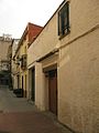
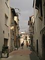
Català: Conjunt del centre antic de Rubí, format pels carrers de Sant Ignasi, Xercavins, Sant Joan i Sant Francesc. El componen habitatges de planta baixa i un o dos pisos, pertanyents al primer creixement urbà durant el segle XVIII. Dins aquest seguit d'edificacions, Cal Montmany i la Farmàcia Parrilla són considerats BCILs autònoms, separats de la resta del conjunt.
This is a category about a building listed in the Catalan heritage register as Bé Cultural d'Interès Local (BCIL) under the reference IPA-39487. |
Subcategories
This category has the following 2 subcategories, out of 2 total.
C
- Cal Montmany (8 F)
F
- Farmàcia Parrilla (4 F)
Media in category "Conjunt del centre antic de Rubí"
The following 4 files are in this category, out of 4 total.
-
 095 Carrer de Sant Ignasi.jpg 1,704 × 2,272; 962 KB
-
 097 Carrer de Xercavins.jpg 1,704 × 2,272; 1.04 MB
-
 099 Carrer de Xercavins, núm. 20-30.jpg 1,704 × 2,272; 1.03 MB
-
 100 Carrer de Xercavins, núm. 20-30.jpg 2,272 × 1,704; 1.14 MB


