Category:Conjunt d'habitatges al carrer del Remei, 39
Jump to navigation
Jump to search
| Object location | | View all coordinates using: OpenStreetMap |
|---|
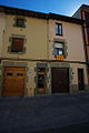
house in Vic, Spain  | |||||
| Upload media | |||||
| Instance of | |||||
|---|---|---|---|---|---|
| Location | Vic, Osona, Catalunya Central, Catalonia | ||||
| Heritage designation |
| ||||
 | |||||
Català: Conjunt d'habitatges al carrer del Remei, 39 (Vic)
This is a category about a building listed in the Catalan heritage register as Bé Cultural d'Interès Local (BCIL) under the reference IPA-24585. |
Media in category "Conjunt d'habitatges al carrer del Remei, 39"
This category contains only the following file.
-
 Vic c.Remei-39-41 IPA24585 0338 resize.jpg 800 × 1,200; 259 KB