Category:Compton Chamberlayne
Jump to navigation
Jump to search
village and civil parish in Wiltshire, United Kingdom  | |||||
| Upload media | |||||
| Instance of | |||||
|---|---|---|---|---|---|
| Location | Wiltshire, South West England, England | ||||
| Population |
| ||||
 | |||||
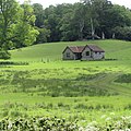
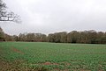
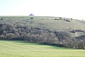
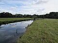
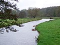
English: Compton Chamberlayne is a small village in south Wiltshire, straddling the A30 road some 8 miles from Salisbury. It is bounded by the villages of Dinton and Baverstock to the north, Barford St Martin to the east, Fovant to the west and Broad Chalke to the south. On its southern border there is high chalk downland and on its northern border is the River Nadder. Most of the inhabited part of the village lies within a small wooded valley which lends credence to the origin of the name "Compton" - coombe tun, or 'settlement in a wooded valley'. The 'Chamberlayne' seems to have been attached when a Robert le Chamberlayne, or possibly Geoffrey le Chaumberlang, took possession of the village in the Middle Ages. The village has a small entry in the Domesday Book which shows that at that time the local manor had a mill, some pastureland, meadows and two woods. Today there is no evidence of the manor.
Nederlands: Compton Chamberlayne is een dorp (village) en civil parish in de unitary authority Wiltshire, in het Engelse graafschap Wiltshire. De civil parish telt
Subcategories
This category has the following 4 subcategories, out of 4 total.
Media in category "Compton Chamberlayne"
The following 132 files are in this category, out of 132 total.
-
 "I'm not entirely sure about you".jpg 4,000 × 2,248; 2.85 MB
-
 'Red Barn', Compton Chamberlayne.jpg 2,992 × 2,992; 2.97 MB
-
 'The Hollow', Compton Chamberlayne 2.jpg 4,000 × 2,664; 4.58 MB
-
 'The Hollow', Compton Chamberlayne.jpg 4,000 × 2,664; 4.45 MB
-
 A bridlepath avenue.jpg 4,000 × 2,248; 3.03 MB
-
 A30 at Compton Chamberlayne - geograph.org.uk - 5831989.jpg 4,288 × 2,848; 2.15 MB
-
 A30 at Compton Mills - geograph.org.uk - 5832631.jpg 2,848 × 4,288; 2.14 MB
-
 A30 at Compton Mills - geograph.org.uk - 5834771.jpg 2,848 × 4,288; 2.04 MB
-
 A30 at Pond Copse - geograph.org.uk - 3555552.jpg 768 × 1,024; 141 KB
-
 A30 by Compton Mills - geograph.org.uk - 353354.jpg 430 × 640; 117 KB
-
 A30 heading west - geograph.org.uk - 5805409.jpg 1,024 × 684; 305 KB
-
 A30 heading west - geograph.org.uk - 5805415.jpg 1,024 × 684; 245 KB
-
 A30 heading west - geograph.org.uk - 5805419.jpg 1,024 × 684; 360 KB
-
 A30 heading west - geograph.org.uk - 5805424.jpg 1,024 × 684; 244 KB
-
 Access road to Dinton Mill.jpg 2,992 × 2,992; 3.48 MB
-
 Access to Naishes Farm - geograph.org.uk - 3555537.jpg 1,024 × 751; 108 KB
-
 Bench Mark, Combe House - geograph.org.uk - 2298056.jpg 480 × 640; 66 KB
-
 Bench Mark, Compton Chamberlayne - geograph.org.uk - 1919454.jpg 480 × 640; 200 KB
-
 Bench Mark, Compton Chamberlayne - geograph.org.uk - 2298130.jpg 480 × 640; 117 KB
-
 Brick bus shelter at Compton Chamberlayne - geograph.org.uk - 6169570.jpg 1,024 × 683; 279 KB
-
 Bridge near Compton Chamberlayne - geograph.org.uk - 1919440.jpg 640 × 480; 172 KB
-
 Bridleway to Broadchalke - geograph.org.uk - 1452145.jpg 640 × 480; 154 KB
-
 Bus shelter serving Compton Chamberlayne - geograph.org.uk - 3555530.jpg 1,024 × 768; 157 KB
-
 Bus shelter, Compton Chamberlayne - geograph.org.uk - 5832505.jpg 4,272 × 2,635; 1.41 MB
-
 Cattle near Compton Chamberlayne - geograph.org.uk - 5832355.jpg 2,041 × 1,124; 420 KB
-
 Chalk scarp at Compton Down - geograph.org.uk - 4549118.jpg 1,920 × 1,440; 648 KB
-
 Chalk scarp near Compton Chamberlayne - geograph.org.uk - 4551942.jpg 1,920 × 2,475; 1.04 MB
-
 Combe House, Compton Chamberlayne - geograph.org.uk - 2297996.jpg 640 × 481; 69 KB
-
 Compton Bus Stop - geograph.org.uk - 267390.jpg 640 × 480; 132 KB
-
 Compton Chamberlayne (geograph 5834833).jpg 4,288 × 2,848; 1.3 MB
-
 Compton Chamberlayne - geograph.org.uk - 329079.jpg 640 × 480; 115 KB
-
 Compton Chamberlayne Bus Shelter.JPG 4,000 × 3,000; 3.76 MB
-
 Compton Chamberlayne cricket field.JPG 4,000 × 3,000; 3.17 MB
-
 Compton Chamberlayne Folly.JPG 4,000 × 3,000; 3.47 MB
-
 Compton Chamberlayne Village Noticeboard - geograph.org.uk - 329151.jpg 640 × 480; 126 KB
-
 Compton Down - geograph.org.uk - 4551968.jpg 1,920 × 1,440; 860 KB
-
 Compton Down, west of Chiselbury - geograph.org.uk - 437775.jpg 640 × 427; 66 KB
-
 Compton Ivers from Manor Farm - geograph.org.uk - 352205.jpg 640 × 430; 80 KB
-
 Compton Mills - geograph.org.uk - 5834756.jpg 4,277 × 2,607; 1.5 MB
-
 Compton Mills industrial site on A30 - geograph.org.uk - 335513.jpg 640 × 430; 166 KB
-
 Corner of field on Compton Down - geograph.org.uk - 6713063.jpg 1,024 × 683; 270 KB
-
 Cottage in Compton Chamberlayne - geograph.org.uk - 329160.jpg 640 × 480; 134 KB
-
 Downland, Compton Chamberlayne - geograph.org.uk - 491484.jpg 640 × 480; 77 KB
-
 Edge of access land on Compton Down - geograph.org.uk - 6713089.jpg 1,024 × 683; 201 KB
-
 Elder by the byway, Compton Down - geograph.org.uk - 1452222.jpg 479 × 640; 209 KB
-

-
 Farmland around Pond Copse - geograph.org.uk - 4551547.jpg 1,920 × 1,440; 661 KB
-
 Farmland below Compton Down - geograph.org.uk - 6713075.jpg 1,024 × 683; 127 KB
-
 Farmland below Compton Down - geograph.org.uk - 6713084.jpg 1,024 × 683; 184 KB
-
 Farmland near Compton Chamberlayne - geograph.org.uk - 5825787.jpg 4,288 × 2,328; 1.76 MB
-
 Fences on the downs - geograph.org.uk - 4551503.jpg 1,920 × 1,440; 812 KB
-
 Field boundary - geograph.org.uk - 4549253.jpg 1,920 × 1,254; 634 KB
-
 Field by Great Wurs Copse - geograph.org.uk - 5832507.jpg 4,288 × 2,848; 1.27 MB
-
 Field north of Compton Chamberlayne - geograph.org.uk - 5834860.jpg 4,288 × 2,848; 2.63 MB
-
 Field, Compton Chamberlayne - geograph.org.uk - 5832285.jpg 4,288 × 2,848; 1.59 MB
-
 Fields below Compton Down - geograph.org.uk - 6713079.jpg 1,024 × 683; 217 KB
-
 Foot of chalk scarp near Compton Chamberlayne - geograph.org.uk - 4551569.jpg 1,920 × 1,440; 992 KB
-

-
 Footbridge near Compton Chamberlayne - geograph.org.uk - 2298121.jpg 640 × 480; 104 KB
-
 Footbridge, Compton Chamberlayne - geograph.org.uk - 5834927.jpg 2,848 × 4,288; 1.75 MB
-
 Footpath from Compton Chamberlayne - geograph.org.uk - 5832332.jpg 4,288 × 2,848; 1.47 MB
-
 Footpath to Compton Chamberlayne - geograph.org.uk - 5832349.jpg 4,288 × 2,848; 1.5 MB
-
 Footpath to Compton Chamberlayne - geograph.org.uk - 5832358.jpg 4,288 × 2,848; 1.89 MB
-
 Fragrant Orchid on the downs - geograph.org.uk - 4551883.jpg 1,920 × 2,434; 637 KB
-
 Gateway by Old Shaftesbury Drove - geograph.org.uk - 4552280.jpg 1,920 × 1,440; 1.13 MB
-
 George V postbox, Compton Chamberlayne - geograph.org.uk - 1135093.jpg 480 × 640; 167 KB
-
 Grass triangle north of Compton Chamberlayne - geograph.org.uk - 5834903.jpg 4,288 × 2,848; 2.16 MB
-
 Grassland south-east of Compton Chamberlayne - geograph.org.uk - 4551562.jpg 1,920 × 1,350; 1,009 KB
-
 Great Wurs Copse - geograph.org.uk - 353366.jpg 640 × 430; 130 KB
-
 Guarding the flock, Baverstock - geograph.org.uk - 2030905.jpg 640 × 481; 73 KB
-
 Hedge, Compton Down - geograph.org.uk - 1452218.jpg 640 × 481; 160 KB
-
 High Street, Compton Chamberlayne - geograph.org.uk - 5832292.jpg 2,387 × 3,122; 864 KB
-
 Horse Shoe Bridge - geograph.org.uk - 329473.jpg 640 × 480; 151 KB
-
 Horse Shoe Bridge - geograph.org.uk - 5835084.jpg 4,263 × 2,630; 1.86 MB
-
 Horseshoe Bridge, Compton Chamberlayne.JPG 4,000 × 3,000; 4.45 MB
-
 In the Nadder valley - geograph.org.uk - 5835046.jpg 4,288 × 2,848; 2.49 MB
-
 Interior of Compton Chamberlayne folly.JPG 4,000 × 3,000; 3.42 MB
-
 King's Elm, Compton Chamberlayne.JPG 4,000 × 3,000; 3.1 MB
-
 Lane in the Nadder valley - geograph.org.uk - 5834973.jpg 4,288 × 2,848; 2.17 MB
-
 Looking east on the Dinton Mill acess road.jpg 2,992 × 2,992; 2.02 MB
-
 Maize, Compton Down - geograph.org.uk - 1452216.jpg 640 × 481; 150 KB
-
 Manor Farm, Compton Chamberlayne - geograph.org.uk - 5832498.jpg 3,945 × 2,252; 1.16 MB
-
 Milestone near Compton Chamberlayne - geograph.org.uk - 1764155.jpg 640 × 480; 184 KB
-
 Milestone near Compton Chamberlayne - geograph.org.uk - 1764178.jpg 640 × 480; 212 KB
-
 New growth in Pond Copse - geograph.org.uk - 358987.jpg 640 × 430; 139 KB
-
 No Fovant Badge - geograph.org.uk - 358994.jpg 640 × 430; 91 KB
-
 Old barn at Manor Farm, circa 1979 - geograph.org.uk - 1805870.jpg 2,556 × 1,704; 4.15 MB
-
 Old Shaston Drove, Compton Down - geograph.org.uk - 1452132.jpg 640 × 480; 194 KB
-
 Old Shaston Drove, Compton Down - geograph.org.uk - 1452221.jpg 480 × 640; 203 KB
-
 Outbuildings at Compton House - geograph.org.uk - 329444.jpg 640 × 480; 85 KB
-
 Parkland, Compton Chamberlayne - geograph.org.uk - 4255005.jpg 640 × 413; 216 KB
-
 Path to St Michaels Church - geograph.org.uk - 329288.jpg 640 × 480; 154 KB
-
 Post Office at Compton Chamberlayne - geograph.org.uk - 6445471.jpg 1,799 × 1,199; 530 KB
-
 Priory Lodge and Priory Cottage - geograph.org.uk - 267395.jpg 640 × 480; 127 KB
-
 River Nadder from Horse Shoe Bridge - geograph.org.uk - 5835095.jpg 2,848 × 4,288; 1.78 MB
-
 River Nadder from Horse Shoe Bridge - geograph.org.uk - 5835108.jpg 2,620 × 4,043; 1.89 MB
-

-
 River Nadder, Compton Chamberlayne.JPG 4,000 × 3,000; 2.57 MB
-
 River Wylye - geograph.org.uk - 1660741.jpg 640 × 480; 134 KB
-
 Roses, Old Shaftesbury Drove - geograph.org.uk - 4552270.jpg 1,920 × 2,560; 1.65 MB
-
 Rows of straw, Compton Down - geograph.org.uk - 1452118.jpg 640 × 480; 181 KB
-
 SP3 214 Compton Chamberlayne kiosk and former post office. (4388014881).jpg 2,304 × 3,072; 3.41 MB
-
 Stile, Compton Down - geograph.org.uk - 4551994.jpg 1,920 × 2,479; 935 KB
-
 Straw bales, Compton Down - geograph.org.uk - 1452220.jpg 640 × 480; 170 KB
-
 Stubble field, Compton Down - geograph.org.uk - 1452161.jpg 640 × 480; 165 KB
-
 Stubble field, Compton Down - geograph.org.uk - 1452206.jpg 640 × 480; 100 KB
-
 Stubble field, Compton Down - geograph.org.uk - 1452209.jpg 640 × 480; 129 KB
-
 Telephone box, Compton Chamberlayne - geograph.org.uk - 1135086.jpg 640 × 480; 153 KB
-
 The A30 at Compton Chamberlayne - geograph.org.uk - 2166798.jpg 640 × 480; 69 KB
-
 The A30, Compton Chamberlayne - geograph.org.uk - 6531441.jpg 1,773 × 1,112; 1.45 MB
-

-
 Top of Hydon Hill - geograph.org.uk - 352716.jpg 640 × 430; 147 KB
-

-
 Track down from Compton Down - geograph.org.uk - 391014.jpg 640 × 430; 133 KB
-
 Track junction on Compton Down - geograph.org.uk - 4552157.jpg 1,920 × 1,440; 991 KB
-
 Track junction, Compton Down - geograph.org.uk - 1452155.jpg 640 × 481; 148 KB
-
 Track to Compton Down - geograph.org.uk - 5832342.jpg 4,288 × 2,848; 1.62 MB
-
 Track to Dinton Mill - geograph.org.uk - 5835006.jpg 4,288 × 2,848; 2.37 MB
-
 Tree by the byway, Compton Down - geograph.org.uk - 1452214.jpg 640 × 480; 139 KB
-
 Trees near Horse Shoe Copse - geograph.org.uk - 5825823.jpg 4,288 × 2,848; 2.07 MB
-
 Trees near Horse Shoe Copse - geograph.org.uk - 5835027.jpg 3,863 × 2,568; 1.26 MB
-
 View along Compton Down - geograph.org.uk - 6713061.jpg 1,024 × 683; 249 KB
-
 View along the scarp slope of Compton Down - geograph.org.uk - 6713085.jpg 1,024 × 683; 241 KB
-
 View from access road to Dinton Mill.jpg 2,992 × 2,992; 2.41 MB
-
 View from Compton Down 2.jpg 4,000 × 2,248; 1.91 MB
-
 View from Compton Downs.jpg 4,000 × 2,248; 1.92 MB
-

-
 View towards Manor Farm - geograph.org.uk - 6713077.jpg 1,024 × 683; 186 KB
-
 Walking group ascending Compton Down - geograph.org.uk - 6445474.jpg 1,198 × 1,798; 468 KB
-
 Wall, Compton Chamberlayne - geograph.org.uk - 5834912.jpg 4,216 × 2,774; 2.1 MB
-
 Wheat field, Compton Down - geograph.org.uk - 1452064.jpg 640 × 479; 111 KB
-
 Wheat field, Compton Down - geograph.org.uk - 1452126.jpg 640 × 480; 123 KB


.jpg)


.jpg)


