Category:Comb Ridge
Jump to navigation
Jump to search
landform in Utah, USA  | |||||
| Upload media | |||||
| Instance of | |||||
|---|---|---|---|---|---|
| Located in protected area | |||||
| Location | Utah | ||||
| Heritage designation | |||||
 | |||||
Media in category "Comb Ridge"
The following 26 files are in this category, out of 26 total.
-
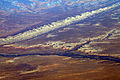 Bluff UT - aerial with San Juan River and Comb Ridge.jpg 3,504 × 2,336; 9.08 MB
-
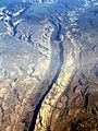
 Comb Ridge Area, Southwest of Abajo Mountains (98450475).jpg 1,200 × 1,600; 804 KB
-
 Comb Ridge Coffee House (4075403520).jpg 2,000 × 1,328; 3.22 MB
-
 Comb Ridge Crest from East.jpg 5,266 × 2,292; 3.22 MB
-
 Comb Ridge Crest from NE.jpg 3,271 × 1,721; 1.06 MB
-
 Comb Ridge from US 163 (2).jpg 6,491 × 2,896; 1.89 MB
-
 Comb Ridge from US 163.jpg 20,647 × 2,708; 5.05 MB
-
 Comb Ridge from West SR 95.jpg 11,578 × 2,315; 4.13 MB
-
 Comb Ridge SR 95 looking North.jpg 4,000 × 3,000; 4.61 MB
-
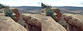 Comb Ridge Stereo.JPG 3,200 × 1,200; 711 KB
-
 Comb Ridge To Mule Ear Diatreme (217585251).jpeg 2,048 × 1,366; 811 KB
-
 Comb Ridge Utah (49806542656).jpg 3,600 × 2,400; 4.6 MB
-
 Comb Ridge Utah 2020.jpg 2,144 × 1,424; 981 KB
-
 Comb Ridge, Utah (14203604414).jpg 4,000 × 2,820; 1.36 MB
-
 Comb Wash, Utah (14017117917).jpg 3,000 × 4,000; 8.48 MB
-
 Eternal Procession.jpg 6,016 × 4,016; 22.65 MB
-
 Gregory 1938 Comb Wash Plate 19.jpg 984 × 618; 233 KB
-
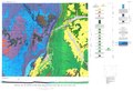
 Gregory 1938 USGS Professional Paper 188 Plate 1.jpg 2,431 × 1,763; 1.22 MB
-
 NE AZ-NW NM NASA.jpg 990 × 830; 645 KB
-
 O'Sullivan 1965 USGS Bulletin 1186 plate-1.jpg 8,600 × 5,900; 4.5 MB
-
 O'Sullivan 1965 USGS Bulletin 1186 plate-1.pdf 6,450 × 4,425; 9.19 MB
-
 Soaring Crane.jpg 6,016 × 4,016; 19 MB
-

-
 USGS Bulletin 1021-E Plate 17.tif 4,245 × 8,389, 5 pages; 5.57 MB
-
 Utah State Route 95 Crossing Comb Wash and Comb Ridge (14201225712).jpg 4,000 × 3,000; 2.92 MB
-
 WolfmanPanelUtah-AttributeAs-PhilKonstantin.jpg 2,241 × 714; 302 KB
.jpg)
.jpg)


.jpg)

.jpeg)
.jpg)

.jpg)
.jpg)


_(3468488058).jpg)
.jpg)
Categories:
- Canyon Lands of Utah
- Canyon Lands of Arizona
- National Natural Landmarks of Arizona
- National Natural Landmarks of Utah
- Colorado Plateau Navajo section
- Faults in the United States
- Tectonic landforms in Utah
- Tectonic landforms in Arizona
- Monoclines in the United States
- Monoclines in Utah
- Landforms on the Navajo Nation
- Landforms of Apache County, Arizona
- Landforms of Navajo County, Arizona
- Landforms of San Juan County, Utah
- Landforms of Bears Ears National Monument
- Locations along U.S. Route 160 in Arizona
- Locations along U.S. Route 163 in Utah
- Locations along U.S. Route 163 in Utah (1970-1981) in San Juan County, Utah
- Locations along Utah State Route 95
- Locations along Utah State Route 47 (1927-1977)
- Locations along the Hole in the Rock Trail