Category:Columbia River Basin
Jump to navigation
Jump to search
drainage basin of the Columbia River in western North America  | |||||
| Upload media | |||||
| Instance of | |||||
|---|---|---|---|---|---|
| Named after | |||||
| Location |
| ||||
| Located in or next to body of water | |||||
| Has part(s) |
| ||||
| Drainage basin | |||||
 | |||||
Subcategories
This category has the following 11 subcategories, out of 11 total.
Media in category "Columbia River Basin"
The following 36 files are in this category, out of 36 total.
-
 Columbia River Basin map-sr.svg 1,480 × 1,474; 1,014 KB
-
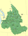
 ColumbiaRiverLocMap.png 500 × 500; 74 KB
-
 Air quality climate in the Columbia River Basin (IA airqualityclimat00ferg).pdf 1,683 × 2,191, 74 pages; 3.17 MB
-
 Columbia Basin Basketry (10027757704).jpg 2,448 × 3,264; 2.21 MB
-
 Columbia basin project.JPG 520 × 823; 92 KB
-
 Columbia dams map-fr.png 1,205 × 1,207; 465 KB
-
 Columbia dams map.png 1,205 × 1,207; 414 KB
-
 Columbia drainage basin map-fr.svg 808 × 790; 3.86 MB
-
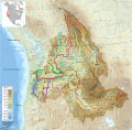 Columbia major tributaries map-fr.svg 808 × 790; 3.89 MB
-
 Columbia River Gorge January 2017.jpg 750 × 498; 118 KB
-
 Columbia salmon accessibility.svg 808 × 790; 3.92 MB
-
 Columbia tributaries drainage basin map-fr.svg 808 × 790; 3.89 MB
-
 Columbia tributaries drainage basin map-it.svg 808 × 790; 3.24 MB
-
 Columbia.png 683 × 760; 40 KB
-
 Columbiarivermap.png 1,500 × 1,500; 3.6 MB
-
 Columbiarivermap.svg 612 × 612; 15.91 MB
-
 Columbiarivermapsnakeriverhighlighted.png 1,500 × 1,500; 3.43 MB
-
 Columbiawdams.png 948 × 1,230; 701 KB
-

-

-
 France Columbia drainage basin Size.svg 645 × 650; 281 KB
-
 An Interior empire - historical overview of the Columbia Basin (IA interiorempirehi00unse).pdf 1,652 × 2,156, 172 pages; 9.45 MB
-

-
 Kane Lodge.jpg 870 × 690; 264 KB
-
 Kettle River Map.png 669 × 727; 103 KB
-
 Kootenayrivermapnew.png 1,152 × 1,145; 2.18 MB
-
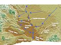 Lake Lewis Basin.jpg 720 × 540; 85 KB
-
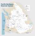 Pacific Northwest River System.png 1,930 × 2,032; 412 KB
-
 Pend Oreille River Map.png 899 × 727; 123 KB
-
 Pend Oreille-Clark Fork dams.jpg 689 × 605; 151 KB
-
 Pendoreillerivermap.jpg 909 × 895; 1.01 MB
-
 Sand dunes near Columbia River, Washington, 1900 (GLACIERS 4989).jpg 768 × 592; 39 KB
-
 Spokane River.JPG 2,576 × 1,920; 1.2 MB
-

-
 Willow Creek Watershed.png 1,051 × 1,125; 1.43 MB
-
 Yakima River Delta.jpeg 4,032 × 3,024; 1.8 MB


.jpg)


_(page_155_crop).jpg)


.jpg)

.png)

