Category:Codicote
Jump to navigation
Jump to search
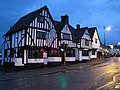
English: Codicote is a large village, about seven miles (11 km) south of Hitchin in Hertfordshire, England. It has timber-framed and chequered brick houses, of special interest being the 18th-century Pond House and the half-timbered "As You Like It" Peking restaurant (formerly the George and Dragon Inn). Codicote Lodge is 18th century and Codicote Bury 17th century. The church, mostly rebuilt in 1853, retains 13th-century work in its nave and aisles. A most unusual structure north of the village is the Node Dairy and Stud, erected in 1927. It is circular in design, and thatched, with a circular courtyard and a tower which is, in fact, a silo. (Sadly, the Node Court Dairy was badly damaged by fire 11-12th July 2015.)
village and civil parish in North Hertfordshire, England  | |||||
| Upload media | |||||
| Instance of | |||||
|---|---|---|---|---|---|
| Location | North Hertfordshire, Hertfordshire, East of England, England | ||||
| Population |
| ||||
| Area |
| ||||
| Said to be the same as | Codicote (Wikimedia duplicated page, civil parish) | ||||
 | |||||
Subcategories
This category has the following 3 subcategories, out of 3 total.
C
G
W
Media in category "Codicote"
The following 157 files are in this category, out of 157 total.
-

-
 A lane with no apparent name - geograph.org.uk - 5392064.jpg 640 × 480; 163 KB
-

-
 A1 (M) by Aunt Wood - geograph.org.uk - 2458369.jpg 640 × 436; 44 KB
-
 A1(M) near Welwyn Heath - geograph.org.uk - 4751756.jpg 640 × 480; 75 KB
-
 A1(M) northbound - geograph.org.uk - 2513663.jpg 640 × 480; 52 KB
-
 A1(M) northbound - geograph.org.uk - 5682946.jpg 640 × 428; 111 KB
-
 A1(M) passing Oaklands - geograph.org.uk - 3590564.jpg 640 × 448; 57 KB
-
 A1(M), northbound - geograph.org.uk - 4646736.jpg 640 × 340; 39 KB
-
 Abbotshay Farm - geograph.org.uk - 191136.jpg 640 × 479; 96 KB
-
 Angel in the churchyard, Codicote - geograph.org.uk - 6384412.jpg 1,430 × 1,867; 989 KB
-
 Asley Grove - a small wood. - geograph.org.uk - 97303.jpg 640 × 482; 108 KB
-
 B656 heading south - geograph.org.uk - 3859933.jpg 640 × 480; 69 KB
-
 Big House at Vanstone Park - geograph.org.uk - 47684.jpg 640 × 480; 20 KB
-
 Bottom farm at Codicote Bottom - geograph.org.uk - 2912653.jpg 640 × 480; 102 KB
-

-
 Bottom Farm, Codicote Bottom - geograph.org.uk - 3532926.jpg 4,320 × 3,240; 4.5 MB
-
 Bridleway at Hogsnorton, Codocote - geograph.org.uk - 6372084.jpg 2,000 × 1,500; 1.51 MB
-
 Bridleway Ford at Kimpton Mill - geograph.org.uk - 3457596.jpg 3,872 × 2,592; 2.39 MB
-
 Bungalows on Codicote Road - geograph.org.uk - 5570729.jpg 2,046 × 1,532; 865 KB
-
 Chalk pit - geograph.org.uk - 160947.jpg 640 × 480; 78 KB
-
 Chalk pit - geograph.org.uk - 160951.jpg 640 × 480; 53 KB
-
 Chaseside Fordson Major - geograph.org.uk - 1342489.jpg 640 × 480; 100 KB
-
 Circles in the grass, Codicote - geograph.org.uk - 6384426.jpg 2,000 × 1,252; 1.11 MB
-

-
 Codicote (5545842337).jpg 2,640 × 1,980; 602 KB
-
 Codicote (5546458976).jpg 1,964 × 1,473; 652 KB
-
 Codicote , "The Globe" public house - geograph.org.uk - 6792428.jpg 2,397 × 2,353; 2.62 MB
-
 Codicote , Parish Church of St Giles - geograph.org.uk - 6792472.jpg 3,648 × 2,736; 4.29 MB
-
 Codicote , tower, Parish Church of St Giles - geograph.org.uk - 6792491.jpg 1,929 × 3,051; 2.2 MB
-
 Codicote , Welcome sign - geograph.org.uk - 6792447.jpg 2,135 × 3,191; 3.34 MB
-
 Codicote - "The Goat" public house (geograph 6816023).jpg 3,372 × 2,681; 2.17 MB
-
 Codicote - geograph.org.uk - 3241137.jpg 856 × 1,280; 306 KB
-
 Codicote Bottom Farm - geograph.org.uk - 4545543.jpg 4,320 × 3,240; 2.93 MB
-
 Codicote Bottom Farm - geograph.org.uk - 5669030.jpg 2,304 × 1,728; 833 KB
-
 Codicote Ford - geograph.org.uk - 3457573.jpg 3,872 × 2,592; 2.38 MB
-
 Codicote Parish Council office - geograph.org.uk - 5570746.jpg 2,048 × 1,536; 1.51 MB
-
 Codicote Telephone Exchange, Herts - geograph.org.uk - 6045895.jpg 2,592 × 1,944; 1.37 MB
-
 Codicote Village - geograph.org.uk - 24287.jpg 640 × 480; 30 KB
-
 Codicote Village - geograph.org.uk - 24290.jpg 640 × 480; 24 KB
-
 Codicote, B656 Codicote Road - geograph.org.uk - 4752721.jpg 640 × 480; 83 KB
-

-
 Codicote, Hertfordshire, St Giles - geograph.org.uk - 5908692.jpg 4,608 × 3,456; 5.22 MB
-
 Codicote, High St., 1962 - geograph.org.uk - 4743505.jpg 2,366 × 1,262; 4.04 MB
-

-
-
 Codicote, The Globe - geograph.org.uk - 1599792.jpg 640 × 480; 77 KB
-
 Codicote, The Opening - geograph.org.uk - 4752734.jpg 640 × 496; 52 KB
-

-
 Cottages and grass triangle at Nup End, Codicote - geograph.org.uk - 6372080.jpg 2,000 × 1,500; 1,003 KB
-
 Cottages in Rabley Heath Rd, Codicote. - geograph.org.uk - 97313.jpg 640 × 482; 121 KB
-
 County Super 6 - geograph.org.uk - 1342511.jpg 640 × 480; 75 KB
-
 Crop field off St Albans Road - geograph.org.uk - 3858103.jpg 640 × 480; 80 KB
-
 Cultivated field seen from Eabley Heath Road, Codicote - geograph.org.uk - 6384454.jpg 2,000 × 1,500; 975 KB
-
 Danesbury Park Road, Welwyn - geograph.org.uk - 5570715.jpg 2,048 × 1,536; 1.08 MB
-
 Doe Dual Drive 130 - geograph.org.uk - 1342501.jpg 640 × 480; 82 KB
-
 Driver's End Lane - geograph.org.uk - 3859999.jpg 640 × 480; 54 KB
-
 Driveway and house at Nup End Green - geograph.org.uk - 4456341.jpg 800 × 487; 73 KB
-

-
 Farm Buildings at Codicote Bottom - geograph.org.uk - 47647.jpg 640 × 480; 20 KB
-
 Farmland near Eiling Lodge - geograph.org.uk - 3859929.jpg 640 × 480; 87 KB
-
 Farmland towards the River Mimram - geograph.org.uk - 3858130.jpg 640 × 480; 80 KB
-
 Farmland, Driver's End - geograph.org.uk - 3859940.jpg 640 × 480; 89 KB
-
 Flooding on Sally Deards Lane - geograph.org.uk - 6372213.jpg 2,000 × 1,501; 1.38 MB
-
 Fly tipping - geograph.org.uk - 4545675.jpg 4,320 × 3,240; 5.2 MB
-
 Ford on Dark Lane - geograph.org.uk - 5392027.jpg 640 × 480; 173 KB
-
 Ford on St Albans Road - geograph.org.uk - 3858101.jpg 640 × 480; 96 KB
-
 Ford over the River Mimram at Codicote Bottom - geograph.org.uk - 3434051.jpg 4,320 × 3,240; 5.7 MB
-
 Gated field off Kimpton Road - geograph.org.uk - 5392046.jpg 640 × 480; 127 KB
-

-
 GOC Kimpton 095 Shepherds Cottage (5723863924).jpg 2,640 × 1,980; 664 KB
-
 GOC Kimpton 103 Ayot Lodge (5723889448).jpg 2,641 × 1,979; 881 KB
-
 Grass triangle, Codicote - geograph.org.uk - 6384448.jpg 2,000 × 1,500; 961 KB
-
 Green opposite the church, Codicote - geograph.org.uk - 6384403.jpg 2,000 × 1,500; 1.26 MB
-
 Hedgerow by the B656 near Knebworth - geograph.org.uk - 5571153.jpg 2,048 × 1,536; 1.03 MB
-
 Hedgerow trees near High Heath Farm - geograph.org.uk - 5392097.jpg 640 × 480; 115 KB
-
 High Heath Farm - geograph.org.uk - 1263446.jpg 640 × 468; 77 KB
-
 High Street at the entrance to Codicote Garden Centre - geograph.org.uk - 2972636.jpg 1,600 × 1,200; 514 KB
-
 High Street Codicote - geograph.org.uk - 2971879.jpg 1,600 × 1,200; 671 KB
-
 High Street Codicote - geograph.org.uk - 2972637.jpg 1,600 × 1,200; 600 KB
-
 High Street Codicote at the junction of New Town - geograph.org.uk - 2972639.jpg 1,600 × 1,200; 531 KB
-
 High Street, Codicote - geograph.org.uk - 5976944.jpg 2,000 × 1,360; 596 KB
-
 Historic bridge, Hoo Park, Codicote 2020-07-19.jpg 4,032 × 2,688; 6.15 MB
-
 Horse chestnut tree on the B656 - geograph.org.uk - 5570933.jpg 1,927 × 1,445; 1.2 MB
-
 House on High Street, Codicote - geograph.org.uk - 5570894.jpg 2,048 × 1,536; 1.51 MB
-
 House on St Albans Road - geograph.org.uk - 3858108.jpg 640 × 480; 77 KB
-
 Improvised passing place, Slip Lane, Old Knebworth - geograph.org.uk - 6372225.jpg 2,000 × 1,500; 933 KB
-

-

-
 Kimpton Road - geograph.org.uk - 3858132.jpg 640 × 480; 65 KB
-
 Kimpton Road at the junction of Heath Hill - geograph.org.uk - 5634514.jpg 2,304 × 1,728; 839 KB
-
 Kimpton Road, Codicote Bottom - geograph.org.uk - 5669029.jpg 2,266 × 1,676; 1.54 MB
-

-
 Looking up the slope from Codicote Bottom - geograph.org.uk - 3532922.jpg 4,320 × 3,240; 5.57 MB
-
 Mansells Lane, Codicote - geograph.org.uk - 6384432.jpg 2,000 × 1,500; 1.25 MB
-
 Mansells Lane, Codicote - geograph.org.uk - 6384442.jpg 2,000 × 1,500; 1.1 MB
-

-
 More Gates in Codicote Bottom - geograph.org.uk - 47653.jpg 640 × 480; 18 KB
-
 Muddy footpath off Slip Lane, Old Knebworth - geograph.org.uk - 6372262.jpg 2,000 × 1,500; 1.16 MB
-
 Node Court, Codicote - geograph.org.uk - 170558.jpg 640 × 480; 89 KB
-
 Parade of Classic tractors, Codicote - geograph.org.uk - 1342517.jpg 640 × 480; 85 KB
-
 Park Lane at Nup End, Codicote - geograph.org.uk - 6372103.jpg 2,000 × 1,498; 751 KB
-
 Part of Rabley Heath Road - geograph.org.uk - 1323969.jpg 640 × 480; 106 KB
-

-
 Ploughed field and trees - geograph.org.uk - 3860003.jpg 640 × 480; 127 KB
-
 Pond House, Codicote - geograph.org.uk - 170568.jpg 640 × 480; 120 KB
-

-

-
 Rabley Heath Road, Codicote - geograph.org.uk - 6372247.jpg 2,000 × 1,500; 1.5 MB
-
 Rabley Heath Road, Tagmore Green, Codicote - geograph.org.uk - 6372197.jpg 2,000 × 1,501; 1.2 MB
-
 Rabley Heath Wr Twr - geograph.org.uk - 97295.jpg 482 × 640; 80 KB
-

-

-
 River Mimram crossing - geograph.org.uk - 160939.jpg 640 × 480; 72 KB
-
 River Mimram, Fulling Mill Lane Ford - geograph.org.uk - 5966834.jpg 1,024 × 768; 275 KB
-
 Road from Codicote, Herts. - geograph.org.uk - 165816.jpg 640 × 480; 104 KB
-
 Road junction in Codicote - geograph.org.uk - 5634519.jpg 2,304 × 1,728; 831 KB
-
 Sally Deards Lane at Hogsnorton, Codicote - geograph.org.uk - 6372107.jpg 2,000 × 1,500; 1.32 MB
-
 Sentinel steam wagon - geograph.org.uk - 1342568.jpg 640 × 480; 86 KB
-
 Sharp bend in Driver's End Lane - geograph.org.uk - 3859997.jpg 640 × 510; 55 KB
-
 Sheep in the churchyard. Codicote - geograph.org.uk - 6384419.jpg 2,000 × 1,497; 1.17 MB
-
 Sign for Node Court at Drivers End - geograph.org.uk - 47657.jpg 640 × 480; 18 KB
-
 Slip Lane - geograph.org.uk - 3860005.jpg 640 × 480; 123 KB
-
 Slip Lane, Old Knebworth - geograph.org.uk - 6372113.jpg 2,000 × 1,500; 1.23 MB
-
 St Albans Road - geograph.org.uk - 3858106.jpg 640 × 480; 93 KB
-
 Tagmore Green - geograph.org.uk - 165809.jpg 640 × 480; 81 KB
-
 Tagmore Park, Tagmore Green, Codicote - geograph.org.uk - 6372194.jpg 2,000 × 1,500; 1.64 MB
-
 Tanyard Lane - geograph.org.uk - 3858137.jpg 480 × 640; 92 KB
-
 The B656 at Tower Lodges, Codicote - geograph.org.uk - 6372092.jpg 2,000 × 1,501; 1 MB
-
 The Bell Motel, Codicote - geograph.org.uk - 5570890.jpg 2,010 × 1,484; 939 KB
-
 The entrance to Codicote Garden Centre - geograph.org.uk - 5570923.jpg 1,889 × 1,378; 780 KB
-
 The entrance to Codicote Garden Centre, High Street - geograph.org.uk - 2972635.jpg 1,600 × 1,200; 575 KB
-
 The last 329 at Nup End - geograph.org.uk - 2106483.jpg 957 × 944; 159 KB
-
 The Node Conference centre off B 656 - geograph.org.uk - 47686.jpg 640 × 480; 21 KB
-
 The Robin Hood and Little John, Rabley Heath, Codicote - geograph.org.uk - 6372259.jpg 2,000 × 1,500; 1.67 MB
-
 The way to Abbotshay - geograph.org.uk - 191141.jpg 640 × 479; 79 KB
-
 Titan tractor ticking over - geograph.org.uk - 1342620.jpg 640 × 480; 66 KB
-
 Tower Lodge Knebworth House (2) - geograph.org.uk - 3787186.jpg 4,320 × 3,240; 6.69 MB
-
 Tower Lodge, Knebworth House - geograph.org.uk - 3787182.jpg 4,320 × 3,240; 5.7 MB
-
 Tower lodges, Knebworth - geograph.org.uk - 5263452.jpg 1,600 × 1,200; 708 KB
-
 Trantor, Mansells Farm near Codicote - geograph.org.uk - 1342534.jpg 640 × 480; 90 KB
-
 Tree and bend, Rabley Heath Road, Codicote - geograph.org.uk - 6384457.jpg 2,000 × 1,443; 1.07 MB
-
 Tree-lined lane near Kimpton Mill - geograph.org.uk - 3434039.jpg 4,320 × 3,240; 5.65 MB
-
 Unnamed road in Codicote - geograph.org.uk - 5669024.jpg 2,304 × 1,728; 846 KB
-
 Unnamed road in Codicote - geograph.org.uk - 5669025.jpg 2,113 × 1,585; 1.28 MB
-

-

-
 View of a red kite flying above the Cat Survival Trust - geograph.org.uk - 5423292.jpg 3,872 × 2,592; 1.31 MB
-

-
 View of rolling countryside from the Cat Survival Trust - geograph.org.uk - 5422995.jpg 3,311 × 1,195; 720 KB
-

-
 View of rolling countryside from the Cat Survival Trust ^3 - geograph.org.uk - 5423332.jpg 3,872 × 2,592; 1.98 MB
-

-
 Welwyn Equestrian Centre - Rabley Heath. - geograph.org.uk - 97280.jpg 640 × 482; 117 KB
-
 Welwyn Ford - geograph.org.uk - 3457561.jpg 3,872 × 2,592; 2.39 MB
-
 Wood pasture near Tower Lodges, Codicote - geograph.org.uk - 6372098.jpg 1,500 × 2,000; 1.83 MB
-
 Woodlands in Codicote - geograph.org.uk - 5669026.jpg 2,304 × 1,728; 850 KB


_by_Aunt_Wood_-_geograph.org.uk_-_2458369.jpg)
_near_Welwyn_Heath_-_geograph.org.uk_-_4751756.jpg)
_northbound_-_geograph.org.uk_-_2513663.jpg)
_northbound_-_geograph.org.uk_-_5682946.jpg)
_passing_Oaklands_-_geograph.org.uk_-_3590564.jpg)
,_northbound_-_geograph.org.uk_-_4646736.jpg)


.jpg)
.jpg)


.jpg)


.jpg)
.jpg)


_-_geograph.org.uk_-_3787186.jpg)


