Category:Coburg Wharf
Jump to navigation
Jump to search
| Object location | | View all coordinates using: OpenStreetMap |
|---|
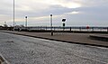
Coburg Wharf is now a road and associated riverside pathway between Coburg Dock and the Mersey.
Media in category "Coburg Wharf"
The following 7 files are in this category, out of 7 total.
-
 Birkenhead waterfront from Coburg Wharf.jpg 4,976 × 2,113; 5.36 MB
-
 Coburg Wharf 1.jpg 5,095 × 3,377; 13.64 MB
-
 Coburg Wharf 2.jpg 5,091 × 3,002; 8.78 MB
-
 Plaque at Coburg Wharf.jpg 3,082 × 4,769; 10.91 MB
-
 View north from Coburg Wharf 1.jpg 4,783 × 3,456; 8.25 MB
-
 View north from Coburg Wharf 2.jpg 5,184 × 3,456; 8.69 MB
-
 View to Coburg Wharf.jpg 5,145 × 3,305; 11.92 MB


