Category:Coastal ship terminal in Gdynia
Jump to navigation
Jump to search
| Object location | | View all coordinates using: OpenStreetMap |
|---|
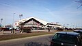
Polski: Gdynia Śródmieście, Aleja Jana Pawła II 2 - budynek dworca żeglugi przybrzeżnej: kasy i terminal "Żeglugi Gdańskiej" i tramwaju wodnego, Restauracja & Cafe Pub "Kapitan Cook", Restauracja "Róża Wiatrów" (od tej ostatniej pochodzi potoczna nazwa całego obiektu - Róża Wiatrów).
Subcategories
This category has the following 2 subcategories, out of 2 total.
R
Media in category "Coastal ship terminal in Gdynia"
The following 4 files are in this category, out of 4 total.
-
 GDYNIA, AB. 047.JPG 1,067 × 800; 159 KB
-

-
 Przejście graniczne w Gdyni przy Nabrzeżu Pomorskim - sierpień 2017.jpg 2,592 × 1,944; 1.48 MB
-
 Terminal Żeglugi Gdańskiej w Gdyni.JPG 3,840 × 2,160; 1.5 MB

.jpg)

