Category:Coast of Wales
Jump to navigation
Jump to search
Subcategories
This category has the following 2 subcategories, out of 2 total.
C
- Coasteering in Wales (9 F)
P
- Portmeirion coast views (108 F)
Media in category "Coast of Wales"
The following 200 files are in this category, out of 311 total.
(previous page) (next page)-
 Aber1.jpg 4,032 × 3,024; 5.85 MB
-
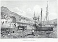 Aberdovey in 1834.jpeg 900 × 646; 312 KB
-
 Arctic Tern, Cemlyn, Ynys Mon 2023.jpg 5,721 × 4,640; 4.38 MB
-
 Barry Harbour Low Tide.jpg 5,184 × 3,456; 7.93 MB
-
 Beach at Pickleridge, near Dale, Pembrokeshire, Wales.jpg 3,000 × 4,000; 5.07 MB
-
 Blue Severn Estuary.jpg 5,184 × 3,456; 5.06 MB
-
 Clarach beach, Dyfi Biosphere.jpg 4,032 × 3,024; 3.42 MB
-
 Cormorant, Aberogwen, 2023.jpg 6,960 × 4,640; 9.28 MB
-
 Craft passing Pen y Cil headland - geograph.org.uk - 2483341.jpg 640 × 480; 64 KB
-
 Craggy Anglesey coastline - geograph.org.uk - 4800934.jpg 640 × 480; 95 KB
-
 Crow Rock - geograph.org.uk - 1825425.jpg 2,816 × 2,120; 1.41 MB
-
 Crow Rock and Linney Head - geograph.org.uk - 1828551.jpg 2,816 × 2,120; 1.42 MB
-
 Exposed rock at Graig Ddu - geograph.org.uk - 2608599.jpg 3,872 × 2,592; 3.46 MB
-

-
 Foreshore and base of limestone pavement near Ogmore Southerndown Coast DMarshall2017.jpg 3,151 × 1,696; 2.18 MB
-
 Freshwater West - geograph.org.uk - 5098205.jpg 2,261 × 1,772; 754 KB
-
 Freshwater West - geograph.org.uk - 5098609.jpg 2,576 × 1,932; 1.26 MB
-
 Friar's Point Framed.jpg 2,666 × 4,000; 8.34 MB
-
 Garn Fôr (Mynydd Gwaith) Trefor, Llŷn.jpg 5,568 × 3,712; 6.84 MB
-
 Great Tor from below - geograph.org.uk - 3594209.jpg 640 × 480; 92 KB
-

-
 Grey Seals, Porth y Dyfn - geograph.org.uk - 4697280.jpg 2,789 × 2,092; 1.24 MB
-
 Griffith Lorts Hole - geograph.org.uk - 3530786.jpg 640 × 480; 98 KB
-
 Guillemots at the Elegug Stacks - geograph.org.uk - 2385695.jpg 1,280 × 960; 575 KB
-
Gweithio gyda'n gilydd er mwyn ein harfordiroedd a'n moroedd - blaenoriaethau a chynnydd.webm 4 min 20 s, 1,920 × 1,080; 148.79 MB
-
 Harry Furlough's Rocks - geograph.org.uk - 1900646.jpg 640 × 407; 240 KB
-
 Headland at Barclodiad y Gawres - geograph.org.uk - 3924277.jpg 4,320 × 3,240; 3.51 MB
-
 Headlands near Abercastle - geograph.org.uk - 1867252.jpg 444 × 640; 82 KB
-
 Hen Borth cove from the south - geograph.org.uk - 2138782.jpg 1,024 × 768; 227 KB
-
 Island and rocky headland at Dinas - geograph.org.uk - 2551624.jpg 3,264 × 2,448; 3.74 MB
-
 Jack Sound and Skokholm - geograph.org.uk - 4783014.jpg 1,024 × 768; 129 KB
-
 Jellyfish in the kelp - geograph.org.uk - 4321662.jpg 1,600 × 1,200; 509 KB
-
 Kelp bed, looking towards Criccieth - geograph.org.uk - 4321632.jpg 1,600 × 1,200; 503 KB
-
 Kelp bed, looking towards Harlech - geograph.org.uk - 4321634.jpg 1,600 × 1,200; 376 KB
-
 Limestone cliffs - geograph.org.uk - 3775687.jpg 640 × 430; 74 KB
-
 Limestone cliffs at the Southern end of Barafundle Bay - geograph.org.uk - 4071927.jpg 3,128 × 2,346; 2.34 MB
-
 Limestone cliffs east of Mewsford Point - geograph.org.uk - 3202701.jpg 4,320 × 3,240; 2.33 MB
-
 Limestone pavement and foreshore near Ogmore Southerndown Coast DMarshall2017.jpg 2,145 × 1,836; 1.34 MB
-
 Little Sound - geograph.org.uk - 4959029.jpg 2,474 × 1,631; 577 KB
-
 Llanddwyn Bay from the West - geograph.org.uk - 3916993.jpg 4,320 × 3,240; 4.31 MB
-
 Llansteffan Castle and Beach.jpg 3,647 × 2,735; 810 KB
-
 Llechau-Uchaf rocks from Ramsey Island - geograph.org.uk - 4033059.jpg 4,608 × 3,456; 4.59 MB
-
 Llyn coast - geograph.org.uk - 3454930.jpg 4,000 × 3,000; 3.19 MB
-
 Llyn Craigypistyll panorama including the dam and peak.jpg 3,696 × 695; 2.05 MB
-
 Llyn Peninsula in the distance from Benar Beach - geograph.org.uk - 4664719.jpg 4,288 × 3,216; 3.55 MB
-
 Looking north from the base of Mowingword - geograph.org.uk - 3581355.jpg 1,224 × 918; 605 KB
-
 Looking out to Sea - geograph.org.uk - 1894325.jpg 640 × 415; 240 KB
-
 Looking south, along the base of Mowingword - geograph.org.uk - 3581356.jpg 1,224 × 918; 630 KB
-

-
 Looking west along The Knap - geograph.org.uk - 1971759.jpg 1,500 × 995; 235 KB
-
 Low spring tide, Borth - geograph.org.uk - 4358483.jpg 5,184 × 3,456; 1.93 MB
-
 Low tide and a typical sky, Oxwich Bay - geograph.org.uk - 4627539.jpg 5,880 × 3,747; 3.19 MB
-
 Low tide on Worm's Head - geograph.org.uk - 3983394.jpg 800 × 531; 107 KB
-
 Low tide on Worm's Head - geograph.org.uk - 3992438.jpg 1,024 × 680; 245 KB
-
 Low tide, Menai Straits - geograph.org.uk - 4433952.jpg 640 × 426; 62 KB
-
 Lower Lias Nash Point Glamorgan.JPG 3,872 × 2,592; 5.73 MB
-
 Maen Bachau - geograph.org.uk - 4112390.jpg 1,600 × 1,200; 563 KB
-
 Maen Cam - geograph.org.uk - 4305599.jpg 2,400 × 3,600; 3.88 MB
-
 Magnificent strata at Pen-y-holt Down - geograph.org.uk - 2385143.jpg 2,592 × 1,944; 2.35 MB
-
 Majestic Sweep of the Bay - geograph.org.uk - 3410804.jpg 3,593 × 2,118; 1.19 MB
-
 Major stump - geograph.org.uk - 3909896.jpg 640 × 480; 59 KB
-
 Making The Best Of It (29024911302).jpg 5,456 × 3,217; 2.2 MB
-
 Malltraeth Bay from Llanddwyn island - geograph.org.uk - 4980343.jpg 5,184 × 3,888; 4.55 MB
-
 Manorbier Sunset - geograph.org.uk - 3168126.jpg 1,980 × 1,282; 533 KB
-
 Map of Southerndown Coast showing SSSIs DMarshall2017.jpg 839 × 600; 67 KB
-
 Menai Straits - geograph.org.uk - 4433949.jpg 640 × 426; 67 KB
-
 Menai Straits - geograph.org.uk - 4477826.jpg 640 × 426; 121 KB
-
 Midland Isle - geograph.org.uk - 4959012.jpg 2,477 × 1,689; 607 KB
-
Morwellt - Porthdinllaen srfordir Pen Llyn, Cymru a'r Morgi Brych.webm 1 min 1 s, 640 × 360; 4.93 MB
-
 Mouth of the artro - geograph.org.uk - 4604965.jpg 640 × 428; 90 KB
-
 Mowingword at low tide (neap) - geograph.org.uk - 3581360.jpg 1,224 × 918; 514 KB
-
 Mowingword cliff - geograph.org.uk - 3581365.jpg 1,224 × 918; 507 KB
-
 Mud around Bangor - geograph.org.uk - 4433972.jpg 640 × 426; 57 KB
-
 Musselwick Bay near Little Haven - geograph.org.uk - 4876786.jpg 2,576 × 1,932; 1.23 MB
-
 Mynydd y Garn and Carmel Head from Holyhead Bay - geograph.org.uk - 2240844.jpg 1,024 × 767; 122 KB
-
 North Pembrokeshire Coast - geograph.org.uk - 2985576.jpg 4,256 × 2,290; 2.77 MB
-
 North Pembrokeshire Coastline - geograph.org.uk - 2985615.jpg 4,244 × 2,630; 3.39 MB
-
 North shore at near noon - geograph.org.uk - 4225071.jpg 640 × 480; 59 KB
-
 North West Edge Of St Tudwal's Island East - geograph.org.uk - 4617089.jpg 2,560 × 1,920; 2.24 MB
-
 Northern end of Whitesands Bay - geograph.org.uk - 1852368.jpg 640 × 427; 66 KB
-
 Ogof Colomennod - geograph.org.uk - 4642671.jpg 1,000 × 750; 657 KB
-
 Ogofau Duon - geograph.org.uk - 4787123.jpg 2,448 × 3,264; 2.54 MB
-
 Ormes Bay - geograph.org.uk - 4893949.jpg 1,000 × 1,000; 596 KB
-
 Out to sea - geograph.org.uk - 3522210.jpg 640 × 480; 94 KB
-
 Out to sea - geograph.org.uk - 4554564.jpg 640 × 428; 88 KB
-
 Oxwich Bay - geograph.org.uk - 4858074.jpg 5,472 × 3,648; 5.03 MB
-
 Oxwich Bay at low tide - geograph.org.uk - 4899588.jpg 6,000 × 4,000; 5.53 MB
-
 Oxwich Bay at low tide - geograph.org.uk - 4899598.jpg 6,000 × 4,000; 6.47 MB
-
 Oxwich Bay at low tide - geograph.org.uk - 4899609.jpg 6,000 × 4,000; 6.06 MB
-
 Paine's Rock - geograph.org.uk - 4071982.jpg 2,346 × 3,128; 1.72 MB
-
 Pains Rock - geograph.org.uk - 4959199.jpg 3,264 × 2,448; 1.99 MB
-
 Pared Mawr - geograph.org.uk - 1823737.jpg 800 × 600; 123 KB
-
 Part of Aber West and Dinas Fawr - geograph.org.uk - 2397227.jpg 640 × 480; 69 KB
-
 Part of the Welsh coast - geograph.org.uk - 3076082.jpg 640 × 480; 66 KB
-
 Passing Pen Anglas - geograph.org.uk - 4784188.jpg 1,024 × 768; 89 KB
-
 Pembrokeshire Coast Path at Atlantic View - geograph.org.uk - 4322771.jpg 1,600 × 1,062; 549 KB
-
 Pembrokeshire Coast Path at Frank's Shore - geograph.org.uk - 4320945.jpg 1,600 × 1,062; 504 KB
-
 Pembrokeshire Coast Path towards Lydstep Haven - geograph.org.uk - 4320992.jpg 1,600 × 1,062; 491 KB
-
 Pen Brush from afar - geograph.org.uk - 4619590.jpg 1,280 × 960; 193 KB
-
 Pen Las Rock - geograph.org.uk - 4525103.jpg 640 × 469; 74 KB
-
 Pen Las Rock, Holy Island - geograph.org.uk - 4525234.jpg 640 × 480; 81 KB
-

-
 Pen-trwyn - geograph.org.uk - 4893901.jpg 1,000 × 585; 465 KB
-
 Pen-y-holt Bay - geograph.org.uk - 2385163.jpg 960 × 1,280; 581 KB
-
 Pen-y-holt stack - geograph.org.uk - 2385160.jpg 1,280 × 960; 567 KB
-
 Pencestyll headland - geograph.org.uk - 4507493.jpg 640 × 480; 77 KB
-
 Penllechwen - geograph.org.uk - 4300247.jpg 3,600 × 2,400; 4.12 MB
-
 Penmaen Dewi (St David's Head) - geograph.org.uk - 2344870.jpg 3,264 × 2,448; 5.91 MB
-
 Penmaenpool toll bridge, Mawddach Estuary SSSI.jpg 4,032 × 3,024; 2.87 MB
-
 Penrhyn Dalar - geograph.org.uk - 4616809.jpg 5,862 × 3,908; 4.2 MB
-
 Penrhyn Halen - geograph.org.uk - 4300196.jpg 3,600 × 2,400; 4.25 MB
-
 Penrhyn Twll on Ramsey Island - geograph.org.uk - 2056896.jpg 640 × 480; 84 KB
-
 Pig Stone - geograph.org.uk - 4959200.jpg 2,448 × 3,264; 3.32 MB
-
 Pigeon Holes - geograph.org.uk - 1827221.jpg 3,072 × 2,304; 3.8 MB
-
 Pondside at Henllys.jpg 5,472 × 3,648; 9.63 MB
-
 Porth Dwfn - geograph.org.uk - 4623634.jpg 5,761 × 3,841; 4.31 MB
-
 Porth Egr - geograph.org.uk - 4081864.jpg 640 × 360; 58 KB
-
 Porth y Nant and Penrhyn Glas, Llŷn AONB.jpg 4,032 × 3,024; 2.17 MB
-
 Porth y Nant and Penrhyn Glas.jpg 4,032 × 3,024; 3.59 MB
-
 Porth y Nant.jpg 5,790 × 3,860; 5.55 MB
-
 Porth y Pistyll - geograph.org.uk - 2915682.jpg 640 × 425; 70 KB
-
 Porth y Pistyll and Aberdaron Bay - geograph.org.uk - 4232923.jpg 480 × 640; 74 KB
-
 Porth y Rhaw - geograph.org.uk - 4320924.jpg 3,600 × 2,400; 3.8 MB
-
 Porth yr Hwngan ac Ynysoedd Gwylanod - geograph.org.uk - 3934195.jpg 1,600 × 1,200; 533 KB
-
 Porthsychan - geograph.org.uk - 2106956.jpg 1,600 × 1,045; 628 KB
-
 Primrose Cliffs - geograph.org.uk - 1903356.jpg 449 × 640; 248 KB
-
 Proud Giltar - geograph.org.uk - 2064063.jpg 1,600 × 1,063; 551 KB
-
 Proud Giltar - geograph.org.uk - 3731272.jpg 640 × 430; 81 KB
-
 Proud Giltar - geograph.org.uk - 4492614.jpg 640 × 402; 64 KB
-
 Puffin Island - geograph.org.uk - 4164454.jpg 1,921 × 1,434; 934 KB
-
 Pwll Ceris - The Swellies - geograph.org.uk - 4972211.jpg 1,000 × 750; 609 KB
-
 Pwll Dwgan - geograph.org.uk - 4322941.jpg 3,600 × 2,400; 4.13 MB
-
 Pwll Glas - geograph.org.uk - 4726044.jpg 1,064 × 1,600; 338 KB
-
 Pwll y Wrach - geograph.org.uk - 3013988.jpg 4,000 × 3,000; 3.4 MB
-
 Red Berry Bay - geograph.org.uk - 4540891.jpg 1,024 × 768; 190 KB
-
 Rest Bay - geograph.org.uk - 2391459.jpg 2,816 × 2,112; 1.05 MB
-
 Rhoscolyn Headland - geograph.org.uk - 4801320.jpg 640 × 480; 68 KB
-
 Rhossili Beach at low tide - geograph.org.uk - 4005331.jpg 4,000 × 3,000; 1.89 MB
-
 Rock Climbers - geograph.org.uk - 1894643.jpg 640 × 427; 308 KB
-
 Rock formations in the walls of Parwyd inlet - geograph.org.uk - 2141105.jpg 1,024 × 513; 156 KB
-
 Rock formations north of Clarach Bay - geograph.org.uk - 2288561.jpg 3,872 × 2,592; 4.78 MB
-
 Rock formations viewed from South Stack - geograph.org.uk - 4426366.jpg 2,112 × 2,816; 1.09 MB
-
 Rock strata at Cobbler's Hole - geograph.org.uk - 2575416.jpg 2,592 × 1,944; 2.03 MB
-
 Rocks at the eastern side of Caswell Bay - geograph.org.uk - 4911157.jpg 6,000 × 4,000; 3.34 MB
-
 Rocks by Porthtaflod - geograph.org.uk - 4613629.jpg 6,000 × 4,000; 4.33 MB
-
 Rocks off the Ceredigion coast - geograph.org.uk - 4104130.jpg 640 × 360; 61 KB
-
 Rocks off the coast at Trwyn Crou - geograph.org.uk - 2016023.jpg 640 × 480; 111 KB
-
 Rocks off the tip of Ynys Llanddwyn - geograph.org.uk - 4872445.jpg 640 × 453; 76 KB
-
 Rocks on the south-east side of Porth Ysgaden - geograph.org.uk - 2056263.jpg 1,024 × 754; 228 KB
-
 Rocks on Trwyn Cemlyn - geograph.org.uk - 1900656.jpg 640 × 410; 201 KB
-
 Rocky coast south of Aberystwyth - geograph.org.uk - 1963217.jpg 640 × 480; 96 KB
-
 Rocky coastline at Porth Nobla - geograph.org.uk - 4208794.jpg 1,600 × 1,009; 569 KB
-

-
 Rocky foreshore on Holyhead Bay - geograph.org.uk - 2352085.jpg 640 × 480; 83 KB
-
 Rough weather and high tide at Clybyddiad - geograph.org.uk - 2615870.jpg 3,257 × 2,284; 2.58 MB
-
 Rugged coastline at Aber Geirch - geograph.org.uk - 2148358.jpg 640 × 480; 80 KB
-
 Rugged coastline at Clybyddiad - geograph.org.uk - 2551544.jpg 3,074 × 2,347; 3.26 MB
-
 Rugged coastline at Clybyddiad - geograph.org.uk - 2551562.jpg 2,448 × 3,264; 3.99 MB
-
 Sail off Paviland, Gower - geograph.org.uk - 2977379.jpg 640 × 480; 70 KB
-
 Sand and sea - geograph.org.uk - 4891403.jpg 640 × 480; 31 KB
-
 Sand ^ Shingle on Traeth Abererch - geograph.org.uk - 2218817.jpg 2,000 × 1,500; 571 KB
-
 Sands and seaweed covered rocks - geograph.org.uk - 2538260.jpg 2,048 × 1,536; 649 KB
-
 Sandstones at Porth Saint - geograph.org.uk - 1891782.jpg 640 × 427; 258 KB
-
 Sandwich tern, Cemliyn, Ynys Mon 2023.jpg 5,205 × 3,298; 4.67 MB
-
 Sandwich Tern, Cemlyn, Ynys Mon 2023.jpg 6,960 × 4,640; 3.99 MB
-
 Sea and land on the Gower - geograph.org.uk - 2977962.jpg 640 × 480; 94 KB
-
 Sea Cliffs at Mount Sion East - geograph.org.uk - 1999139.jpg 800 × 600; 150 KB
-

-
 Sea, sky and rock - geograph.org.uk - 1876492.jpg 800 × 600; 163 KB
-
 Seabird colony below Pen Clegyr - geograph.org.uk - 2006984.jpg 800 × 600; 171 KB
-
Seagrass Meadow - Porthdinllaen.webm 1 min 1 s, 640 × 360; 5.22 MB
-
 Seal of the coast of Lleyn - geograph.org.uk - 4519857.jpg 640 × 360; 50 KB
-
 Seals in a Sheltered Rocky Recess - geograph.org.uk - 3669660.jpg 1,024 × 887; 220 KB
-
 Seals near Chapel Point on Caldey Island - geograph.org.uk - 4622390.jpg 4,000 × 3,000; 4.65 MB
-
 Seals on Ynys-y-cranc - geograph.org.uk - 1811287.jpg 640 × 480; 153 KB
-
 Seashore south of Church Bay - geograph.org.uk - 1885433.jpg 2,592 × 1,944; 1.2 MB
-
 Selfie at the beach (21737122346).jpg 5,257 × 3,505; 8.24 MB
-
 Severn Estuary Boats.jpg 5,184 × 3,456; 4.87 MB
-
 Severn Estuary Evening Light.jpg 5,472 × 3,648; 4.26 MB
-
 Severn Estuary from Beechwood.jpg 5,472 × 3,648; 6.87 MB
-
 Severn Estuary Panorama.jpg 5,184 × 3,456; 4.67 MB
-
 Severn Estuary Sunset.jpg 5,184 × 3,456; 6.18 MB
-
 Sheep at Porth y Nant.jpg 5,698 × 3,798; 6.36 MB
-
 Sheep Island - geograph.org.uk - 4438413.jpg 640 × 480; 76 KB
-
 ShellIsland.jpg 2,816 × 2,112; 2.52 MB
-
 Shingle beach at Penychain - geograph.org.uk - 2218825.jpg 2,000 × 1,500; 1,007 KB
-
 Shingle beach near Penychain - geograph.org.uk - 2218829.jpg 2,000 × 1,500; 1.03 MB
-
 Shingle ridge - geograph.org.uk - 4608372.jpg 4,320 × 3,240; 4.93 MB
-
 Shoreline at Cefn Sidan Beach - geograph.org.uk - 2456348.jpg 1,024 × 768; 185 KB
-
 Skomer Island landscape 05.jpg 2,961 × 3,948; 4.71 MB
-
 Skomer Island puffin a landscape 07.jpg 1,622 × 2,100; 1.21 MB
-
 Skomer Island puffin bubble landscape 01.jpg 3,024 × 4,032; 4.86 MB
-
 Skomer Island puffin landscape 06.jpg 4,032 × 3,024; 4.03 MB
-
 Skomer Island sea and daisies.jpg 3,024 × 4,032; 4.5 MB
-
Skomer Marine Conservation Zone.webmhd.webm 1 min 10 s, 1,280 × 720; 16.58 MB
-
 Slap and trickle - geograph.org.uk - 1876472.jpg 800 × 600; 136 KB
-
 Small cove - geograph.org.uk - 1851257.jpg 640 × 480; 77 KB
-
 Southerndown Coast Cliffs.jpg 5,184 × 3,456; 5.53 MB
-
 Southerndown Coast looking south east DMarshall2017.jpg 3,264 × 1,836; 2.38 MB
-
 Spur Island - geograph.org.uk - 3843717.jpg 640 × 480; 115 KB


_Trefor,_Ll%C5%B7n.jpg)


.jpg)


_-_geograph.org.uk_-_3581360.jpg)


_-_geograph.org.uk_-_2344870.jpg)


.jpg)


