Category:Climate diagrams of East Timor
Jump to navigation
Jump to search
Subcategories
This category has only the following subcategory.
C
Media in category "Climate diagrams of East Timor"
The following 25 files are in this category, out of 25 total.
-
 Aileu Klimadiagramm.png 586 × 516; 22 KB
-
 Ainaro Klimadiagramm.png 586 × 518; 23 KB
-
 Atabae Klimadiagramm.png 584 × 514; 21 KB
-
 Baucau Klimadiagramm.png 588 × 516; 20 KB
-
 Betano Klimadiagramm.png 586 × 517; 21 KB
-
 Dili Klimadiagramm.png 586 × 510; 19 KB
-
 Gleno Klimadiagramm.png 589 × 513; 20 KB
-
 Hatolia Vila Klimadiagramm.png 589 × 513; 22 KB
-
 Iliomar Klimadiagramm.png 589 × 513; 22 KB
-
 Lautém Klimadiagramm.png 591 × 516; 21 KB
-
 Liquiçá Klimadiagramm.png 586 × 512; 20 KB
-
 Lospalos Klimadiagramm.png 589 × 514; 21 KB
-
 Maliana Klimadiagramm.png 590 × 514; 22 KB
-
 Manatuto Klimadiagramm.png 588 × 514; 20 KB
-
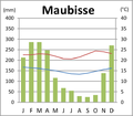 Maubisse Klimadiagramm.png 590 × 514; 23 KB
-
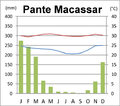 Pante Macassar Klimadiagramm.png 586 × 517; 30 KB
-
 Remexio Klimadiagramm.png 582 × 512; 22 KB
-
 Same Klimadiagramm.png 587 × 517; 24 KB
-
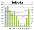 Soibada Klimadiagramm.png 583 × 516; 23 KB
-
 Suai Klimadiagramm.png 587 × 516; 21 KB
-
 Uma Boco Klimadiagramm.png 587 × 518; 26 KB
-
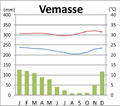 Vemasse Klimadiagramm.png 584 × 515; 21 KB
-
 Venilale Klimadiagramm.png 587 × 509; 21 KB
-
 Viqueque Klimadiagramm.png 588 × 518; 22 KB
-
 Warming Stripes for East Timor from 1901-2018 .png 3,780 × 1,890; 25 KB


