Category:Cleggan
Jump to navigation
Jump to search
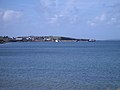
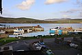
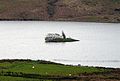
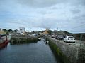
English: Cleggan ( meaning head) is a picturesque fishing village in County Galway, Ireland. The village lies 10 km (7 mi) northwest of Clifden and is situated at the head of Cleggan Bay.
village in County Galway, Ireland  | |||||
| Upload media | |||||
| Instance of | |||||
|---|---|---|---|---|---|
| Location |
| ||||
| Population |
| ||||
| Elevation above sea level |
| ||||
 | |||||
Media in category "Cleggan"
The following 53 files are in this category, out of 53 total.
-
 Across the bay - geograph.org.uk - 5948517.jpg 640 × 480; 61 KB
-
 Bay facing west - geograph.org.uk - 4654813.jpg 640 × 480; 61 KB
-
 Bennabeola Quartzite - geograph.org.uk - 5948487.jpg 480 × 640; 117 KB
-
 Blanket bog - geograph.org.uk - 5948380.jpg 640 × 480; 69 KB
-
 Blick vom Fährterminal auf Cleggan.JPG 2,048 × 1,536; 778 KB
-
 Cleggan (2409307129).jpg 3,888 × 2,592; 2.27 MB
-
 Cleggan (2409307815).jpg 3,888 × 2,592; 2.47 MB
-
 Cleggan (2410139196).jpg 3,888 × 2,592; 2.63 MB
-
 Cleggan (2410142362).jpg 3,888 × 2,592; 3.05 MB
-
 Cleggan (2410154268).jpg 3,888 × 2,592; 2.96 MB
-
 Cleggan Bay track - geograph.org.uk - 5943093.jpg 640 × 480; 72 KB
-
 Cleggan Bay, looking towards Cleggan - geograph.org.uk - 493601.jpg 640 × 480; 86 KB
-
 Cleggan Harbour (1) - geograph.org.uk - 5526077.jpg 4,320 × 3,240; 1.89 MB
-
 Cleggan Harbour - geograph.org.uk - 1842425.jpg 1,280 × 960; 292 KB
-
 Cleggan harbour and bay.jpg 6,240 × 4,160; 7.91 MB
-
 Cleggan Harbour Ferry “Island Discovery” 2018 09 03.jpg 3,476 × 1,648; 3.37 MB
-
 Cleggan Harbour.jpg 6,240 × 4,160; 7.83 MB
-
 Cleggan Head - geograph.org.uk - 5943149.jpg 640 × 480; 72 KB
-
 Cleggan Lake 01 (3585820274).jpg 2,560 × 1,920; 513 KB
-
 Cleggan Lake 02 (3585821382).jpg 2,187 × 1,479; 561 KB
-
 Cleggan Lake 03 (3585825640).jpg 2,560 × 1,920; 2.28 MB
-
 Cleggan Lake 04 (3585826984).jpg 2,350 × 1,842; 640 KB
-
 Cleggan Mountain coastline - geograph.org.uk - 5943145.jpg 640 × 480; 74 KB
-
 Cleggan Quay - geograph.org.uk - 1842412.jpg 1,280 × 960; 317 KB
-
 Cleggan, the lifeboat slipway - geograph.org.uk - 1842445.jpg 1,024 × 791; 180 KB
-
 Cleggan, the main slipway - geograph.org.uk - 1842432.jpg 1,024 × 768; 131 KB
-
 ClegganPierandHarbour.JPG 1,075 × 806; 153 KB
-
 End of the mountain - geograph.org.uk - 5943134.jpg 640 × 480; 94 KB
-
 Eroded bay - geograph.org.uk - 5948442.jpg 640 × 480; 92 KB
-
 Ferry at Cleggan Pier - geograph.org.uk - 5937008.jpg 640 × 480; 60 KB
-
 Inishbofin (2410147710).jpg 3,888 × 2,592; 2.56 MB
-
 Inishbofin Ferry.jpg 6,240 × 4,160; 6.99 MB
-
 Ireland Cleggan (3104326069).jpg 3,888 × 2,592; 6.54 MB
-
 Lane to Cleggan House - geograph.org.uk - 5943073.jpg 640 × 480; 80 KB
-
 Loch Natawny - geograph.org.uk - 4654838.jpg 640 × 480; 52 KB
-
 Looking south along the causeway - geograph.org.uk - 837005.jpg 640 × 480; 68 KB
-
 Megalithic tomb - geograph.org.uk - 5926297.jpg 640 × 480; 77 KB
-
 Monolithic grave Sallerna Bay (2409306523).jpg 3,888 × 2,592; 3.31 MB
-
 Navigation light - geograph.org.uk - 5948455.jpg 640 × 480; 72 KB
-
 Oliver's Seafood Bar and Restaurant.jpg 6,240 × 4,160; 8.99 MB
-
 Ooeyaveigh - geograph.org.uk - 5948370.jpg 640 × 480; 70 KB
-
 R379 road.jpg 2,560 × 1,920; 1.34 MB
-
 Rock outcrop, towards Cleggan Head - geograph.org.uk - 5943116.jpg 640 × 480; 94 KB
-
 Rough Pasture west of Cleggan - geograph.org.uk - 1840258.jpg 1,024 × 786; 161 KB
-
 Ruined farmstead - geograph.org.uk - 4654833.jpg 640 × 480; 65 KB
-
 Storm beach with stream - geograph.org.uk - 5948536.jpg 640 × 480; 100 KB
-
 Terminal island - geograph.org.uk - 5948402.jpg 640 × 480; 52 KB
-
 The "Galway Bay" at Cleggan - geograph.org.uk - 2753366.jpg 640 × 397; 81 KB
-
 Towards Cleggan Head - geograph.org.uk - 5943141.jpg 640 × 480; 70 KB
-
 Track and sheep - geograph.org.uk - 5943100.jpg 640 × 480; 82 KB
-
 View to Lough Anillaun - geograph.org.uk - 5948558.jpg 640 × 480; 83 KB
-
 Lough Anillaun, near Cleggan - geograph.org.uk - 493609.jpg 640 × 480; 107 KB
-
 Quay at Cleggan - geograph.org.uk - 55157.jpg 640 × 427; 98 KB


.jpg)
.jpg)
.jpg)
.jpg)
.jpg)


_-_geograph.org.uk_-_5526077.jpg)


.jpg)
.jpg)
.jpg)
.jpg)


.jpg)

.jpg)


.jpg)


