Category:Clapham, North Yorkshire
Jump to navigation
Jump to search
village in North Yorkshire, United Kingdom  | |||||
| Upload media | |||||
| Instance of | |||||
|---|---|---|---|---|---|
| Location | Clapham cum Newby, North Yorkshire, Yorkshire and the Humber, England | ||||
 | |||||
English: Clapham is a village in the Craven district of North Yorkshire, England. It was previously in the West Riding of Yorkshire. It lies within the Yorkshire Dales National Park 6 miles north west of Settle just off the A65.
Subcategories
This category has the following 8 subcategories, out of 8 total.
Media in category "Clapham, North Yorkshire"
The following 177 files are in this category, out of 177 total.
-
 'The Lake' - geograph.org.uk - 283147.jpg 640 × 480; 189 KB
-
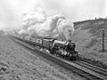 4472 FLYING SCOTSMAN approaches Clapham.jpg 1,024 × 768; 345 KB
-
 4472 FLYING SCOTSMAN crosses Welling Viaduct (1).jpg 1,024 × 768; 304 KB
-
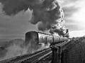 4472 FLYING SCOTSMAN crosses Welling Viaduct.jpg 1,024 × 768; 267 KB
-
 A Wish Tree on a yew stump, Ingleborough Nature Trail, Clapham, Yorkshire.jpg 4,896 × 2,752; 4.36 MB
-
 A Wish Tree on a yew, Ingleborough Nature Trail, Clapham, Yorkshire.jpg 4,896 × 2,752; 4.93 MB
-
 Above Clapdale Wood - geograph.org.uk - 1490054.jpg 640 × 480; 169 KB
-
 Above Trow Gill - geograph.org.uk - 766302.jpg 640 × 480; 119 KB
-
 An entrance to Ingleborough Hall - geograph.org.uk - 1777539.jpg 640 × 480; 199 KB
-
 Aunt Bessie's Grotto, Ingleborough, Clapham Beck, North Yorkshire.jpg 4,896 × 2,752; 5.49 MB
-
 B6480 - geograph.org.uk - 1777510.jpg 640 × 480; 151 KB
-
 B6480, Clapham - geograph.org.uk - 1777508.jpg 640 × 480; 129 KB
-
 Bar Pot - geograph.org.uk - 546909.jpg 640 × 480; 126 KB
-

-
 Bench mark on Clapham Bridge - geograph.org.uk - 3239321.jpg 640 × 480; 147 KB
-
 Bridge over Clapham Beck in Clapham (7872).jpg 4,288 × 2,848; 6.46 MB
-
 Bridge over Clapham Beck in Clapham (7875).jpg 4,288 × 2,848; 6.34 MB
-
 Bridge over Clapham Beck in Clapham (7876).jpg 4,288 × 2,848; 6.37 MB
-
 Bridge over Clapham Beck in Clapham (7880).jpg 4,288 × 2,848; 6.29 MB
-
 Bridge over Clapham Beck in Clapham (7881).jpg 4,288 × 2,848; 6.26 MB
-
 Bridge over Crook Beck - geograph.org.uk - 283127.jpg 640 × 480; 240 KB
-
 Bridge that - geograph.org.uk - 1777514.jpg 640 × 480; 212 KB
-
 Bridge, Clapham - geograph.org.uk - 766329.jpg 640 × 480; 144 KB
-
 Brokken Bridge - geograph.org.uk - 4748036.jpg 640 × 426; 124 KB
-
 Brokken Bridge, Clapham - geograph.org.uk - 2700423.jpg 1,280 × 960; 207 KB
-
 Brokken Bridge, Clapham - geograph.org.uk - 271932.jpg 640 × 480; 246 KB
-
 Brokken Bridge, Clapham - geograph.org.uk - 283142.jpg 480 × 640; 296 KB
-
 Carrot Countdown - geograph.org.uk - 283138.jpg 640 × 480; 220 KB
-
 Cattle underpass - geograph.org.uk - 236563.jpg 640 × 480; 180 KB
-
 Cave Rescue Organisation Clapham Depot - geograph.org.uk - 1777523.jpg 640 × 480; 143 KB
-
 Cemetery Crina Bottom - geograph.org.uk - 264529.jpg 480 × 640; 144 KB
-
 Church Avenue, Clapham - geograph.org.uk - 546822.jpg 640 × 480; 83 KB
-
 Clapdale - geograph.org.uk - 546833.jpg 640 × 480; 81 KB
-
 Clapdale Drive - geograph.org.uk - 1565688.jpg 640 × 480; 137 KB
-
 Clapdale Farm - geograph.org.uk - 1813071.jpg 640 × 426; 236 KB
-
 Clapham Beck in Clapham (7868).jpg 4,288 × 2,848; 6.23 MB
-
 Clapham Beck in Clapham (7869).jpg 4,288 × 2,848; 6.36 MB
-
 Clapham Beck in Clapham (7877).jpg 4,288 × 2,848; 6.25 MB
-
 Clapham Beck, North Yorkshire, England. Cherry petals.jpg 4,896 × 2,752; 5.71 MB
-
 Clapham Beck, North Yorkshire, England.jpg 4,896 × 2,752; 6.43 MB
-
 Clapham Bents - geograph.org.uk - 1386275.jpg 640 × 480; 80 KB
-
 Clapham Bottoms and Pen-y-ghent - geograph.org.uk - 858925.jpg 640 × 480; 77 KB
-
 Clapham Bridge - geograph.org.uk - 3568319.jpg 1,600 × 1,200; 1.01 MB
-
 Clapham Bridge - geograph.org.uk - 4051404.jpg 4,000 × 3,000; 6.46 MB
-
 Clapham Bridge and the B6480 - geograph.org.uk - 3239399.jpg 640 × 480; 97 KB
-
 Clapham Cemetery - geograph.org.uk - 283136.jpg 640 × 480; 264 KB
-
 Clapham Church - geograph.org.uk - 271939.jpg 640 × 480; 235 KB
-
 Clapham from the A65 - geograph.org.uk - 4109084.jpg 640 × 481; 60 KB
-
 Clapham Manor House - geograph.org.uk - 236583.jpg 640 × 480; 126 KB
-
 Clapham market cross, North Yorkshire, England.jpg 4,896 × 2,752; 3.73 MB
-
 Clapham Telephone Exchange, North Yorks - geograph.org.uk - 2093374.jpg 3,072 × 2,304; 1.78 MB
-
 Clapham Village Hall - geograph.org.uk - 749174.jpg 640 × 426; 58 KB
-
 Clapham Village Store - geograph.org.uk - 1777511.jpg 640 × 480; 138 KB
-
 Clapham Village.jpg 1,049 × 700; 1.5 MB
-
 Clapham Waterfall.jpg 534 × 800; 918 KB
-
 Clapham Wood Hall - geograph.org.uk - 1977707.jpg 640 × 480; 126 KB
-
 Clapham, North Yorkshire geograph-3475477-by-Ben-Brooksbank.jpg 2,396 × 1,403; 2.78 MB
-
 Clapham, Yorkshire, Farrer Lodge - geograph.org.uk - 3441136.jpg 3,600 × 2,700; 7.33 MB
-
 Clapham, Yorkshire, Road junction - geograph.org.uk - 3441297.jpg 4,320 × 3,240; 6.83 MB
-
 Coat of Arms - geograph.org.uk - 1777537.jpg 640 × 480; 194 KB
-
 Crina Bottom Farm - geograph.org.uk - 283133.jpg 640 × 480; 163 KB
-
 Crook Beck near Clapham - geograph.org.uk - 283130.jpg 640 × 480; 245 KB
-
 Dry Stone Wall on Brunt Riggs - geograph.org.uk - 701298.jpg 427 × 640; 296 KB
-
 Drystone Wall Near Hagg - geograph.org.uk - 712819.jpg 640 × 427; 277 KB
-
 Eggshell Lane, Clapham - geograph.org.uk - 555315.jpg 640 × 480; 126 KB
-
 Entering the Forest of Bowland - geograph.org.uk - 768026.jpg 640 × 480; 92 KB
-
 Entrance to tunnel - geograph.org.uk - 1417774.jpg 640 × 425; 149 KB
-
 Farmland near Clapham - geograph.org.uk - 2464254.jpg 1,600 × 1,200; 456 KB
-
 Fell Beck - geograph.org.uk - 547084.jpg 640 × 480; 124 KB
-
 Footpath to Clapham - geograph.org.uk - 1490048.jpg 640 × 480; 198 KB
-
 Former Mill, Clapham.jpg 1,024 × 668; 156 KB
-
 Former Post Office, Clapham - geograph.org.uk - 1777507.jpg 480 × 640; 64 KB
-
 Growing With Grace, Clapham - geograph.org.uk - 2521552.jpg 640 × 480; 102 KB
-
 Hall Garth - geograph.org.uk - 4748041.jpg 640 × 420; 94 KB
-
 Harryhorse Stone^ - geograph.org.uk - 157255.jpg 640 × 480; 114 KB
-

-
 Horse drawn logging Wheels, Ingleborough Estates, Clapham, North Yorkshire.jpg 4,896 × 2,752; 4.11 MB
-
 House on Riverside - geograph.org.uk - 4748000.jpg 640 × 411; 58 KB
-
 House, Church Avenue - geograph.org.uk - 4736151.jpg 640 × 426; 74 KB
-
 Houses in Clapham - geograph.org.uk - 1813059.jpg 640 × 426; 239 KB
-
 Ingleborough from the south east - geograph.org.uk - 635146.jpg 597 × 400; 95 KB
-
 Ingleborough Grotto, Clapham Beck, Ingleborough, North Yorkshire, England.jpg 4,896 × 2,752; 5.46 MB
-
 Inglebro ascent.jpg 752 × 500; 338 KB
-
 Know Gap Barn - geograph.org.uk - 273029.jpg 640 × 318; 103 KB
-
 Lane out of Clapham - geograph.org.uk - 858885.jpg 640 × 480; 65 KB
-
 Logging Wheels, Ingleborough Estates, Clapham, North Yorkshire.jpg 4,896 × 2,752; 4.11 MB
-
 Market Cross, Clapham - geograph.org.uk - 4927417.jpg 900 × 1,204; 291 KB
-
 Millennium memorial stone carving - geograph.org.uk - 1417886.jpg 640 × 425; 333 KB
-
 Minor road towards Clapham - geograph.org.uk - 2464245.jpg 1,600 × 1,200; 528 KB
-
 Money tree - geograph.org.uk - 1417865.jpg 640 × 425; 406 KB
-
 Money tree - geograph.org.uk - 536430.jpg 640 × 480; 106 KB
-
 Narrow Footbridge - Clapham - geograph.org.uk - 1938637.jpg 1,500 × 889; 1.95 MB
-
 New Close Lane - geograph.org.uk - 264050.jpg 640 × 480; 126 KB
-
 New Inn - geograph.org.uk - 4748080.jpg 640 × 426; 87 KB
-
 Newby - geograph.org.uk - 51528.jpg 640 × 480; 137 KB
-
 Newby Moor - geograph.org.uk - 264075.jpg 640 × 480; 108 KB
-
 Not to be confused with Clapham London - geograph.org.uk - 858897.jpg 640 × 480; 148 KB
-
 One of the bridges in Clapham - geograph.org.uk - 1650323.jpg 640 × 428; 118 KB
-
 Ordnance Survey One-Inch Sheet 25 Ribblesdale, Published 1924.jpg 11,993 × 9,024; 11.58 MB
-
 Ordnance Survey Sheet SD 76 Clapham (Yorkshire), Published 1952.jpg 11,248 × 11,255; 24.77 MB
-
 Outside Clapham Station - geograph.org.uk - 1384529.jpg 640 × 480; 98 KB
-
 Overhanging tree - geograph.org.uk - 1417817.jpg 640 × 425; 439 KB
-
 P5 - geograph.org.uk - 1333605.jpg 640 × 480; 170 KB
-
 Public Conveniences, Clapham - geograph.org.uk - 546818.jpg 640 × 480; 104 KB
-
 Railway bridge, Clapham - geograph.org.uk - 2464250.jpg 1,600 × 1,200; 616 KB
-
 River Wenning, Clapham - geograph.org.uk - 2464249.jpg 1,600 × 1,200; 749 KB
-
 River Wenning, Clapham - geograph.org.uk - 2464569.jpg 1,600 × 1,200; 841 KB
-
 RJF Rhodo.jpg 1,049 × 700; 1.43 MB
-
 Road Bridge Clapham - geograph.org.uk - 1054825.jpg 640 × 420; 132 KB
-
 Road by Clapham Station - geograph.org.uk - 1384535.jpg 640 × 480; 110 KB
-
 Road sign, Clapham - geograph.org.uk - 4748007.jpg 426 × 640; 119 KB
-
 Servants Tunnel - geograph.org.uk - 4736183.jpg 640 × 426; 117 KB
-
 Sheep - geograph.org.uk - 140676.jpg 640 × 480; 108 KB
-
 Sheep on Herningside - geograph.org.uk - 701338.jpg 640 × 427; 251 KB
-
 Shooting Hut - geograph.org.uk - 140675.jpg 640 × 480; 103 KB
-
 Short footpath from Church Lane Clapham - geograph.org.uk - 2488526.jpg 1,024 × 768; 236 KB
-
 Station Road towards Clapham village - geograph.org.uk - 2464255.jpg 1,600 × 1,200; 486 KB
-
 Stile above Trow Gill - geograph.org.uk - 283164.jpg 640 × 480; 142 KB
-
 Stone bench - geograph.org.uk - 1417833.jpg 640 × 425; 404 KB
-
 Stone foot bridge - geograph.org.uk - 1417810.jpg 640 × 425; 375 KB
-
 The approach to Clapham station. - geograph.org.uk - 283125.jpg 640 × 480; 280 KB
-
 The Ingleborough Grotto, Clapham Beck, Ingleborough, North Yorkshire, England.jpg 4,896 × 2,752; 4.45 MB
-
 The Lake - geograph.org.uk - 766323.jpg 640 × 480; 94 KB
-

-

-
 The Molestrangler, Stile Pot.jpg 3,422 × 2,649; 4.13 MB
-
 The Path from Gaping Gill near Trow Gill - geograph.org.uk - 320931.jpg 640 × 480; 121 KB
-
 The Portcullis duck in Disappointment Pot,.jpg 3,077 × 2,154; 2.11 MB
-
 The view that they came to admire - geograph.org.uk - 283148.jpg 480 × 640; 215 KB
-
 The way to Clapham village - geograph.org.uk - 271921.jpg 640 × 480; 239 KB
-

-
 The Wish Tree on a yew stump, Ingleborough Nature Trail, Clapham, Yorkshire.jpg 4,896 × 2,752; 5.17 MB
-
 The Wish Tree on yew branches, Ingleborough Nature Trail, Clapham, Yorkshire.jpg 4,896 × 2,752; 4.35 MB
-
 Thwaite Scars - geograph.org.uk - 271943.jpg 640 × 480; 138 KB
-
 Track approaching Clapdale Wood - geograph.org.uk - 546827.jpg 640 × 480; 93 KB
-
 Tunnel on the bridleway - geograph.org.uk - 858890.jpg 640 × 480; 149 KB
-
 Upper and lower tunnels - geograph.org.uk - 1417781.jpg 640 × 425; 135 KB
-
 Very worn path above Trow Gill - geograph.org.uk - 283162.jpg 640 × 480; 146 KB
-
 Victoria 60 Years Memorial, Clapham, Yorkshire.jpg 4,896 × 2,752; 3.56 MB
-
 Victorian Stone bench, Clapham, North Yorkshire.jpg 4,896 × 2,752; 5.63 MB
-
 View over "The Lake" - geograph.org.uk - 395169.jpg 640 × 427; 122 KB
-
 Water falls - panoramio.jpg 1,194 × 1,631; 758 KB
-
 Weir near Clapham Cave - geograph.org.uk - 283153.jpg 640 × 480; 260 KB
-
 Wish Tree on a yew, Ingleborough Nature Trail, Clapham, Yorkshire.jpg 4,896 × 2,752; 4 MB
-
 Woodland ,Conisber - geograph.org.uk - 264047.jpg 640 × 480; 153 KB
-
 Yew Tree Cottages - geograph.org.uk - 4748010.jpg 640 × 426; 82 KB
-
 Ancient settlement - geograph.org.uk - 109807.jpg 640 × 480; 130 KB
-
 Ascending Little Ingleborough - geograph.org.uk - 548600.jpg 640 × 480; 77 KB
-
 Barn Middle Birks Farm - geograph.org.uk - 172709.jpg 640 × 480; 68 KB
-
 Burnt Heather - geograph.org.uk - 159187.jpg 640 × 480; 116 KB
-

-
 Clapham - geograph.org.uk - 141640.jpg 640 × 434; 79 KB
-

-
 Cold Stone - geograph.org.uk - 770208.jpg 640 × 480; 86 KB
-
 Converted Barn - geograph.org.uk - 768042.jpg 640 × 480; 80 KB
-
 Crina Bottom Farm trig - geograph.org.uk - 140642.jpg 640 × 480; 96 KB
-
 Crossroads just South of Clapham - geograph.org.uk - 51537.jpg 640 × 480; 187 KB
-
 Deep Pothole near Rayside Plantation - geograph.org.uk - 272983.jpg 640 × 357; 106 KB
-
 Descending Little Ingleborough - geograph.org.uk - 766286.jpg 640 × 480; 49 KB
-
 Dry Valley near Ingleborough Cave - geograph.org.uk - 546891.jpg 640 × 480; 110 KB
-
 Fell Beck - geograph.org.uk - 701305.jpg 427 × 640; 319 KB
-
 Folly, Clapdale Drive - geograph.org.uk - 766315.jpg 480 × 640; 119 KB
-
 Gas Pipeline - geograph.org.uk - 768030.jpg 640 × 480; 51 KB
-
 Gorse Keasden - geograph.org.uk - 172695.jpg 640 × 480; 88 KB
-
 Jack Beck - geograph.org.uk - 165062.jpg 480 × 640; 147 KB
-
 Kettles Beck - geograph.org.uk - 165059.jpg 640 × 480; 119 KB
-
 Kettles Beck - geograph.org.uk - 176698.jpg 640 × 480; 113 KB
-
 Know Gap - geograph.org.uk - 272881.jpg 640 × 480; 99 KB
-
 Long Kin West - geograph.org.uk - 232061.jpg 640 × 480; 148 KB
-
 Long Kin West Pot - geograph.org.uk - 157866.jpg 480 × 640; 151 KB
-
 Long Lane - geograph.org.uk - 109653.jpg 640 × 480; 103 KB
-
 Path to Ingleborough - geograph.org.uk - 547086.jpg 640 × 480; 84 KB
-
 Pipes - geograph.org.uk - 273172.jpg 640 × 480; 99 KB
-
 Shooting Hut - geograph.org.uk - 159177.jpg 640 × 480; 112 KB
-
 Sign and Ingleborough - geograph.org.uk - 140677.jpg 640 × 480; 77 KB
-
 Track to Gayclops Farm - geograph.org.uk - 176699.jpg 640 × 480; 85 KB
-
 Track to Low Birks Farm - geograph.org.uk - 172712.jpg 640 × 480; 110 KB


.jpg)


.jpg)
.jpg)
.jpg)
.jpg)
.jpg)


.jpg)
.jpg)
.jpg)


,_Published_1952.jpg)


