Category:Cladymore
Jump to navigation
Jump to search
English: Cladymore ( Irish: Claddagh Mór) is a small village and townland in County Armagh, Northern Ireland. In the 2001 Census it had a population of 129 people. It is situated within the Armagh City and District Council area.
village in the United Kingdom  | |||||
| Upload media | |||||
| Instance of | |||||
|---|---|---|---|---|---|
| Location | Northern Ireland | ||||
 | |||||
Media in category "Cladymore"
The following 18 files are in this category, out of 18 total.
-
 Art in Cladymore^ - geograph.org.uk - 1533957.jpg 640 × 480; 92 KB
-
 Black Quarter Road, Cladymore - geograph.org.uk - 1533933.jpg 640 × 480; 109 KB
-
 Cattle, Corran Townland - geograph.org.uk - 1429945.jpg 640 × 480; 90 KB
-
 Clady More Townland - geograph.org.uk - 1542423.jpg 640 × 480; 80 KB
-
 Clady More Townland - geograph.org.uk - 1542435.jpg 640 × 480; 95 KB
-
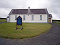 Cladymore Presbyterian Church - geograph.org.uk - 1515599.jpg 640 × 480; 56 KB
-
 Cladymore Presbyterian Church - geograph.org.uk - 547709.jpg 640 × 480; 99 KB
-
 Cladymore Presbyterian Church Manse - geograph.org.uk - 729635.jpg 640 × 480; 63 KB
-
 Cladymore Presbyterian Church School - geograph.org.uk - 729638.jpg 640 × 480; 56 KB
-
 Cladymore Townland - geograph.org.uk - 1406621.jpg 640 × 480; 53 KB
-
 Cladymore village - geograph.org.uk - 1533938.jpg 640 × 480; 87 KB
-
 Crossroads near Cladymore - geograph.org.uk - 1533924.jpg 640 × 480; 93 KB
-
 Game runs off Viewpoint Road - geograph.org.uk - 5271203.jpg 2,097 × 1,112; 610 KB
-
 House on the Viewpoint Road - geograph.org.uk - 5271182.jpg 2,509 × 1,633; 780 KB
-
 Leonard's, Cladymore - geograph.org.uk - 1533928.jpg 640 × 480; 96 KB
-
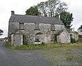 Licensed Premises (Long since closed) - geograph.org.uk - 547717.jpg 640 × 516; 118 KB
-
 Mourneview Park, Cladymore - geograph.org.uk - 1533940.jpg 640 × 480; 95 KB
-
 Sign, Clady Beg - geograph.org.uk - 1533906.jpg 640 × 480; 127 KB


_-_geograph.org.uk_-_547717.jpg)

