Category:Clachnaharry
Jump to navigation
Jump to search
human settlement in Highland, Scotland, UK  | |||||
| Upload media | |||||
| Instance of | |||||
|---|---|---|---|---|---|
| Location |
| ||||
 | |||||
Clachnaharry is a former fishing village, now part of the city of Inverness in the Highland Council Area. Clachnaharry is situated on the south shore of the Beauly Firth, about 2 miles (3 km) west of the city centre.
Subcategories
This category has the following 4 subcategories, out of 4 total.
C
- Clachnaharry Swing Bridge (33 F)
- Clachnaharry Works Lock (11 F)
Media in category "Clachnaharry"
The following 69 files are in this category, out of 69 total.
-
 44871 steaming through Clachnaharry - geograph.org.uk - 4942343.jpg 2,850 × 2,146; 2.46 MB
-
 A train to Dingwall - geograph.org.uk - 1544070.jpg 640 × 480; 76 KB
-
 A862 alongside the Beauly Firth - geograph.org.uk - 4751736.jpg 1,600 × 1,053; 321 KB
-
 A862 and welcome sign - geograph.org.uk - 4750179.jpg 1,024 × 624; 134 KB
-
 Alpha - panoramio (7).jpg 4,000 × 3,000; 6.18 MB
-
 Beached boat, Clachnaharry - geograph.org.uk - 1544122.jpg 640 × 480; 83 KB
-
 Beauly Firth - geograph.org.uk - 4001539.jpg 4,608 × 3,456; 4.2 MB
-
 Beauly Firth - geograph.org.uk - 4814719.jpg 640 × 492; 57 KB
-
 Beauly Firth at Clachnaharry - geograph.org.uk - 5577159.jpg 640 × 337; 78 KB
-
 Beauly Firth foreshore - geograph.org.uk - 3857591.jpg 1,024 × 768; 252 KB
-
 Beauly Firth Mudflats - geograph.org.uk - 4612596.jpg 640 × 480; 53 KB
-
 Beauly Firth View - geograph.org.uk - 3088609.jpg 640 × 360; 64 KB
-
 Beauly Firth, Clachnaharry - geograph.org.uk - 2718344.jpg 1,280 × 856; 128 KB
-
 Beauly Firth, Clachnaharry - geograph.org.uk - 2718375.jpg 1,280 × 856; 146 KB
-
 Beauly Firth, South Kessock - geograph.org.uk - 4814725.jpg 640 × 393; 55 KB
-
 Buildings by Workshop lock on the Caledonian canal - geograph.org.uk - 3739529.jpg 4,320 × 3,240; 5.4 MB
-
 Caledonian Canal at Clachnaharry - geograph.org.uk - 2011598.jpg 800 × 531; 168 KB
-
 Caledonian Canal at Dusk - geograph.org.uk - 6365452.jpg 800 × 500; 34 KB
-
 Caledonian Canal Sea Lock at Dusk - geograph.org.uk - 6370815.jpg 800 × 600; 50 KB
-
 Caledonian Canal, Clachnaharry - geograph.org.uk - 2718334.jpg 1,280 × 856; 124 KB
-
 Caledonian Canal, Clachnaharry - geograph.org.uk - 4814721.jpg 640 × 414; 46 KB
-
 Caledonian Canal, Muirtown Basin - geograph.org.uk - 6069869.jpg 3,968 × 2,976; 1.56 MB
-
 Clachnaharry - Mid Street - geograph.org.uk - 443520.jpg 640 × 480; 87 KB
-
 Clachnaharry railway footbridge - geograph.org.uk - 897533.jpg 640 × 427; 94 KB
-
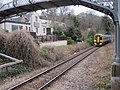 Clachnaharry railway station (site), Highland (geograph 4413623).jpg 1,600 × 1,200; 525 KB
-
 Clachnaharry sea lock - geograph.org.uk - 1994613.jpg 1,024 × 768; 182 KB
-
 Clachnaharry Sea Lock - geograph.org.uk - 6363982.jpg 1,024 × 768; 186 KB
-
 Clachnaharry Sea Lock Pier - geograph.org.uk - 4751727.jpg 3,072 × 2,304; 1.12 MB
-
 Clachnaharry Sea Lock, Caledonian Canal - geograph.org.uk - 3593363.jpg 1,600 × 1,072; 243 KB
-
 Clachnaharry signal box - geograph.org.uk - 1544138.jpg 480 × 640; 83 KB
-
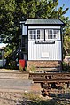 Clachnaharry signal box - geograph.org.uk - 2011626.jpg 531 × 800; 258 KB
-
 Clachnaharry Signal Box - geograph.org.uk - 473376.jpg 640 × 480; 95 KB
-
 Clachnaharry viewed from the sea loch - geograph.org.uk - 2011615.jpg 800 × 531; 239 KB
-
 Dunolly House, Clachnaharry - geograph.org.uk - 4478211.jpg 2,948 × 2,000; 2.15 MB
-
 Entrance to Muirtown Basin - geograph.org.uk - 3703100.jpg 640 × 428; 70 KB
-
 High Street, Clachnaharry, Inverness - geograph.org.uk - 4570970.jpg 640 × 480; 60 KB
-
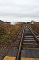 Highland Line - geograph.org.uk - 4774969.jpg 418 × 640; 353 KB
-
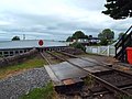
 Level crossing - Clachnaharry - geograph.org.uk - 2717957.jpg 1,280 × 856; 133 KB
-

-
-
 Low Row, Clachnaharry - geograph.org.uk - 4818577.jpg 480 × 640; 51 KB
-
 Low Row, Clachnaharry - geograph.org.uk - 4818578.jpg 480 × 640; 64 KB
-
 Low Row, Clachnaharry - geograph.org.uk - 4818604.jpg 640 × 480; 68 KB
-
 Low Street, Clachnaharry - geograph.org.uk - 1544103.jpg 640 × 480; 128 KB
-
 Muirton Basin Caledonian Canal - geograph.org.uk - 6425384.jpg 1,024 × 768; 204 KB
-
 Muirtown Basin from Clachnaharry - geograph.org.uk - 6567915.jpg 1,024 × 768; 136 KB
-
 Muirtown Basin towards Clachnaharry - geograph.org.uk - 6584363.jpg 1,024 × 768; 81 KB
-
 Muirtown Basin, Caledonian Canal - geograph.org.uk - 5799201.jpg 640 × 480; 56 KB
-
 Mysterious Bubbles - geograph.org.uk - 4774972.jpg 640 × 640; 478 KB
-
 Railway at Clachnaharry - geograph.org.uk - 1978883.jpg 640 × 480; 159 KB
-
 Rainbow across the Beauly Firth - geograph.org.uk - 4818608.jpg 480 × 640; 47 KB
-
 Sea lock at Clachnaharry - geograph.org.uk - 5614527.jpg 640 × 480; 44 KB
-
 Station - panoramio (22).jpg 4,000 × 3,000; 3.46 MB
-
 Sunset in the West - geograph.org.uk - 4882196.jpg 640 × 640; 60 KB
-
 Sunset in the West - geograph.org.uk - 4882198.jpg 640 × 640; 66 KB
-
 Sure Shamal, Clachnaharry - geograph.org.uk - 5326580.jpg 3,000 × 2,200; 2.17 MB
-
 The Beauly Firth - geograph.org.uk - 6019265.jpg 1,024 × 768; 303 KB
-
 The Beauly Firth - geograph.org.uk - 6366596.jpg 800 × 571; 131 KB
-

-
 The Beauly Firth near Clachnaharry - geograph.org.uk - 5614538.jpg 640 × 480; 42 KB
-
 The Caledonian Canal - geograph.org.uk - 5861678.jpg 1,024 × 762; 259 KB
-
 The Caledonian Canal enters the Beauly Firth - geograph.org.uk - 6574478.jpg 1,024 × 768; 85 KB
-
 The Caledonian Canal enters the Beauly Firth - geograph.org.uk - 6630288.jpg 1,024 × 768; 113 KB
-
 The Clachnaharry signal box - geograph.org.uk - 5741940.jpg 480 × 640; 273 KB
-
 The Muirtown Basin - geograph.org.uk - 6567917.jpg 1,024 × 768; 140 KB
-
 The Muirtown Basin at Clachnaharry - geograph.org.uk - 6567933.jpg 1,024 × 768; 85 KB
-
 The northern extremity of the Caledonian Canal - geograph.org.uk - 6772502.jpg 1,024 × 768; 465 KB
-
 View of the Clachnaharry Sea Lock on a calm morning - geograph.org.uk - 3590994.jpg 2,560 × 1,920; 2.91 MB
-
 Walking beside the canal - geograph.org.uk - 5743538.jpg 640 × 480; 191 KB


.jpg)


,_Highland_(geograph_4413623).jpg)


.jpg)


