Category:City Station (St Crispin's) Bridge
Jump to navigation
Jump to search
This is a category about listed building number 1051868. |
| Object location | | View all coordinates using: OpenStreetMap |
|---|
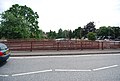
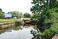
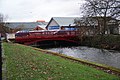
English: This one of a pair of bridges which carry the inner ring road over the river Wensum. This is a wrought iron bridge and was built in 1882 to give access to the new City Station. It has an openwork parapet and the letters 'Norwich Barnard Bishop and Barnard 1882'. The bridge was incorporated into the inner ring road with the parallel new bridge built next to it in the 1970s.
bridge in Norwich, Norfolk, England, UK _Bridge,_Norwich,_Norfolk_(1).jpg) | |||||
| Upload media | |||||
| Instance of | |||||
|---|---|---|---|---|---|
| Location | Norwich, Norfolk, East of England, England | ||||
| Heritage designation |
| ||||
 | |||||
Media in category "City Station (St Crispin's) Bridge"
The following 11 files are in this category, out of 11 total.
-
 -2018-07-14 City Station (St Crispin's) Bridge, Norwich, Norfolk (1).jpg 800 × 529; 481 KB
-
 -2018-07-14 City Station (St Crispin's) Bridge, Norwich, Norfolk (2).jpg 800 × 600; 474 KB
-
 -2018-07-14 City Station (St Crispin's) Bridge, Norwich, Norfolk (3).jpg 800 × 630; 549 KB
-
 -2018-07-14 City Station (St Crispin's) Bridge, Norwich, Norfolk.jpg 800 × 508; 404 KB
-
 A147 bridge over River Wensum - geograph.org.uk - 3797894.jpg 640 × 480; 142 KB
-
 A147 bridges across the River Wensum - geograph.org.uk - 1973942.jpg 640 × 430; 148 KB
-
 St Crispin's Bridge - geograph.org.uk - 2695535.jpg 640 × 430; 90 KB
-
 St Crispin's Rd Bridge - geograph.org.uk - 1398554.jpg 640 × 430; 168 KB
-
 St Crispins Bridge - geograph.org.uk - 3828832.jpg 3,872 × 2,592; 4.07 MB
-
 St Crispins Bridge Norwich.JPG 2,271 × 1,454; 2.13 MB
-
 St Crispins Bridge, Information Board, Norwich.JPG 1,418 × 1,581; 1.11 MB
_Bridge,_Norwich,_Norfolk_(2).jpg)
_Bridge,_Norwich,_Norfolk_(3).jpg)
_Bridge,_Norwich,_Norfolk.jpg)


