Category:Cilybebyll
Jump to navigation
Jump to search
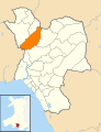
English: Cilybebyll is a village and community in the principal area of Neath Port Talbot, in Wales.
village   | |||||
| Upload media | |||||
| Instance of | |||||
|---|---|---|---|---|---|
| Location | Neath Port Talbot, Wales | ||||
| Heritage designation | |||||
| Population |
| ||||
| Area |
| ||||
 | |||||
Subcategories
This category has the following 2 subcategories, out of 2 total.
A
- Alltwen (17 F)
R
- Rhos, Neath Port Talbot (2 F)
Media in category "Cilybebyll"
The following 192 files are in this category, out of 192 total.
-
 2010 Wales Neath Port Talbot Community Cilybebyll map.svg 512 × 666; 423 KB
-
 2024 Wales Neath Port Talbot Community Cilybebyll map.svg 512 × 666; 548 KB
-
 30 to 20 along New Road, Rhos - geograph.org.uk - 3888052.jpg 799 × 800; 153 KB
-
 A natural bridge over the River Clydach - geograph.org.uk - 6290167.jpg 3,065 × 2,200; 3.61 MB
-
 A road reclaimed by nature - geograph.org.uk - 6290176.jpg 2,048 × 1,536; 1.59 MB
-
 A4067 looking north - geograph.org.uk - 3281982.jpg 640 × 480; 47 KB
-
 A4067 passes Pontardawe - geograph.org.uk - 3281985.jpg 640 × 480; 56 KB
-
 A474 Neath Road - geograph.org.uk - 3285296.jpg 640 × 480; 62 KB
-

-

-
 Access road west of New Road, Rhos - geograph.org.uk - 3887608.jpg 800 × 582; 183 KB
-
 Afon Tawe - geograph.org.uk - 4298664.jpg 640 × 480; 102 KB
-
 Alltwen Primary School near Pontardawe - geograph.org.uk - 3868507.jpg 800 × 545; 130 KB
-
 Bales of Hay - geograph.org.uk - 5974343.jpg 3,093 × 2,321; 2.42 MB
-
 Bales of hay - geograph.org.uk - 5974349.jpg 3,264 × 2,448; 2.06 MB
-

-
 Brecon Railway Building - geograph.org.uk - 4566510.jpg 1,200 × 1,600; 357 KB
-
 Brecon Railway Cutting - geograph.org.uk - 4566485.jpg 1,200 × 1,600; 283 KB
-
 Brecon Railway Revetment Wall - geograph.org.uk - 4566488.jpg 1,200 × 1,600; 420 KB
-
 Brecon Railway Waterfall - geograph.org.uk - 4566569.jpg 1,200 × 1,600; 323 KB
-
 Bridge over stream - geograph.org.uk - 6289227.jpg 2,048 × 1,536; 1.65 MB
-
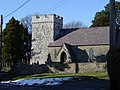 Cilybebyll Church - geograph.org.uk - 133383.jpg 640 × 480; 109 KB
-
 Copse in wetland - geograph.org.uk - 6289220.jpg 2,048 × 1,536; 1.58 MB
-
 Crynant Forest - geograph.org.uk - 5974474.jpg 3,050 × 2,287; 2.15 MB
-
 Cwmnantllwyd Road, Gellinudd - geograph.org.uk - 3886034.jpg 800 × 524; 119 KB
-
 Cycling into and out of Fforest Goch - geograph.org.uk - 3891173.jpg 797 × 800; 146 KB
-
 Cyffordd o draciau - Junction of tracks - geograph.org.uk - 6374067.jpg 1,024 × 768; 207 KB
-

-

-

-

-
 Delffordd, Rhos - geograph.org.uk - 3888147.jpg 800 × 518; 107 KB
-

-
 Drainage channel, Gellinudd - geograph.org.uk - 3887607.jpg 800 × 696; 235 KB
-

-
 Dyffryn Road, Alltwen - geograph.org.uk - 3885854.jpg 800 × 659; 173 KB
-
 Dyffryn Road, Alltwen - geograph.org.uk - 5974320.jpg 3,264 × 2,448; 1.92 MB
-

-
 Eyes everywhere^ - geograph.org.uk - 6015180.jpg 3,264 × 2,448; 3.92 MB
-
 Farmhouse and footpath - geograph.org.uk - 5974415.jpg 3,264 × 2,448; 3 MB
-
 Ffarm Bryn Ysgallog - Bryn Ysgallog Farm - geograph.org.uk - 6399561.jpg 1,024 × 768; 322 KB
-
 Ffarm Pen y Graig - Pen y Graig Farm - geograph.org.uk - 6399590.jpg 1,024 × 767; 326 KB
-

-

-

-
 Fforest Goch Farm - geograph.org.uk - 3893585.jpg 800 × 485; 129 KB
-
 Field and woodland - geograph.org.uk - 5974361.jpg 3,264 × 2,448; 2.15 MB
-
 Footbridge over River Clydach - geograph.org.uk - 6446565.jpg 1,024 × 647; 294 KB
-
 Footbridge over stream - geograph.org.uk - 5974525.jpg 2,448 × 3,264; 3.28 MB
-
 Footbridge over the A4067 at Pontardawe - geograph.org.uk - 3075956.jpg 2,918 × 2,109; 1.07 MB
-
 Footpath east from New Road, Rhos - geograph.org.uk - 3887614.jpg 696 × 800; 268 KB
-
 Forest Goch - geograph.org.uk - 6238750.jpg 1,872 × 1,333; 758 KB
-

-

-

-

-
 Gat Mochyn Gelli Nudd kissing gate - geograph.org.uk - 3794179.jpg 640 × 480; 131 KB
-
 Glais Road closure - geograph.org.uk - 2628289.jpg 2,880 × 1,913; 4.4 MB
-
 Graig Road houses, Alltwen - geograph.org.uk - 3885846.jpg 800 × 483; 110 KB
-
 Green-roofed bungalow in Fforest Goch - geograph.org.uk - 3893600.jpg 800 × 514; 104 KB
-
 Heal fach yn Wernddu - Minor road at Wernddu - geograph.org.uk - 6393246.jpg 1,024 × 768; 343 KB
-
 Hen adeilad glofaol - Former colliery building - geograph.org.uk - 6401021.jpg 1,024 × 768; 323 KB
-
 Hen Heol Gelli Nudd Old Road - geograph.org.uk - 3794149.jpg 690 × 518; 257 KB
-
 Hen wal gerrig sych - Old dry stone wall - geograph.org.uk - 6374091.jpg 1,024 × 767; 300 KB
-
 Heol fach yn Wernddu - Minor road in Wernddu - geograph.org.uk - 6393248.jpg 1,024 × 768; 304 KB
-
 Heol fynedfa i'r goedwig - Forestry access road - geograph.org.uk - 6399541.jpg 1,024 × 768; 275 KB
-
 Heol Penygraig Road - geograph.org.uk - 4195110.jpg 640 × 480; 95 KB
-
 Heol-y-Nant, Rhos - geograph.org.uk - 3888070.jpg 800 × 530; 114 KB
-

-
 Houses near the southern edge of Rhos - geograph.org.uk - 3890924.jpg 800 × 504; 103 KB
-

-
 Impenetrable scrub - geograph.org.uk - 6289277.jpg 2,448 × 3,264; 4.81 MB
-
 Junction and Memorials on Cwmtawe Cycleway - geograph.org.uk - 3678939.jpg 1,024 × 768; 183 KB
-
 Kissing gate and footpath - geograph.org.uk - 5974534.jpg 3,171 × 2,379; 2.44 MB
-

-
 Landslip at Pantteg, Ystalyfera - geograph.org.uk - 3292893.jpg 1,280 × 960; 222 KB
-
 Llwybr Bryn Ysgallog - Bryn Ysgallog Path - geograph.org.uk - 6399566.jpg 1,024 × 768; 358 KB
-
 Llwybr Cefn Celfi Footpath - geograph.org.uk - 3794204.jpg 690 × 518; 253 KB
-
 Llwybr Cilhendre - Cilhendre Path - geograph.org.uk - 5148119.jpg 640 × 480; 131 KB
-

-
 Llwybr Nant y Llechau Path - geograph.org.uk - 4195073.jpg 640 × 480; 149 KB
-

-
 Llwybr Primrose Path - geograph.org.uk - 4195154.jpg 640 × 480; 137 KB
-
 Llwybr Rhos Footpath - geograph.org.uk - 3798014.jpg 690 × 518; 228 KB
-
 Llwybr Tarenni Gleision - Tarenni Gleision Path - geograph.org.uk - 6399543.jpg 1,024 × 768; 325 KB
-
 Llwybr Tarenni Gleision - Tarenni Gleision Path - geograph.org.uk - 6399555.jpg 1,024 × 768; 314 KB
-
 Lon Catwg, Gellinudd - geograph.org.uk - 3886025.jpg 800 × 558; 147 KB
-
 Lon Hendrecaradog - Hendrecaradog Lane - geograph.org.uk - 2234517.jpg 690 × 518; 213 KB
-
 Lon Hir, Alltwen - geograph.org.uk - 3868497.jpg 800 × 511; 112 KB
-
 Long climb away from Pontardawe - geograph.org.uk - 3885829.jpg 800 × 629; 127 KB
-
 Maes y Cornel, Alltwen - geograph.org.uk - 3887624.jpg 800 × 562; 118 KB
-
 Meadow Fish Bar ^ Restaurant, Rhos - geograph.org.uk - 3887605.jpg 800 × 495; 109 KB
-
 Memorial Bench and bus shelter, Rhos - geograph.org.uk - 3890997.jpg 800 × 624; 132 KB
-
 Memorial to Gleision Mine Disaster - geograph.org.uk - 3678945.jpg 1,024 × 768; 205 KB
-
 Mile Stone, Neath 4 miles - geograph.org.uk - 3830256.jpg 480 × 640; 84 KB
-
 Mill Row, Alltwen near Pontardawe - geograph.org.uk - 3868448.jpg 753 × 800; 200 KB
-
 Mountain bike track - geograph.org.uk - 5974483.jpg 2,448 × 3,264; 3.84 MB
-
 Mountain stream - geograph.org.uk - 6289207.jpg 2,448 × 3,264; 4.14 MB
-
 Mynydd Marchywel - geograph.org.uk - 3795091.jpg 690 × 518; 196 KB
-
 Nant Gelli Nedd - geograph.org.uk - 3794160.jpg 690 × 518; 233 KB
-

-
 Neath Road houses in Fforest Goch - geograph.org.uk - 3893575.jpg 800 × 566; 146 KB
-
 Neath Road houses, Rhos - geograph.org.uk - 3888227.jpg 800 × 568; 124 KB
-
 Neath Road looking south - geograph.org.uk - 3285299.jpg 640 × 480; 60 KB
-
 New Footbridge - geograph.org.uk - 6436962.jpg 1,024 × 587; 276 KB
-
 New Road houses, Rhos - geograph.org.uk - 3887616.jpg 800 × 511; 111 KB
-
 Northern boundary of Rhos - geograph.org.uk - 3887610.jpg 753 × 800; 113 KB
-
 Old style signpost arm in Rhos - geograph.org.uk - 3888133.jpg 640 × 640; 97 KB
-
 Old-style signpost in Gellinudd - geograph.org.uk - 3886084.jpg 800 × 528; 110 KB
-
 Ordnance Survey Cut Mark - geograph.org.uk - 3830210.jpg 640 × 480; 92 KB
-
 Ordnance Survey Cut Mark - geograph.org.uk - 3830222.jpg 480 × 640; 86 KB
-
 Ordnance Survey Cut Mark - geograph.org.uk - 3830230.jpg 480 × 640; 120 KB
-
 Ordnance Survey Cut Mark - geograph.org.uk - 3830237.jpg 480 × 640; 98 KB
-
 Ordnance Survey Cut Mark - geograph.org.uk - 3830246.jpg 480 × 640; 106 KB
-
 Ordnance Survey Cut Mark - geograph.org.uk - 3830252.jpg 480 × 640; 75 KB
-
 Ordnance Survey Cut Mark - geograph.org.uk - 3830261.jpg 640 × 480; 54 KB
-
 Ordnance Survey Cut Mark - geograph.org.uk - 3830268.jpg 640 × 480; 105 KB
-
 Ordnance Survey Cut Mark - geograph.org.uk - 3830270.jpg 480 × 640; 109 KB
-
 Ordnance Survey Cut Mark - geograph.org.uk - 3830277.jpg 480 × 640; 94 KB
-
 Ordnance Survey Cut Mark - geograph.org.uk - 3830281.jpg 480 × 640; 97 KB
-
 Ordnance Survey Cut Mark - geograph.org.uk - 3830288.jpg 640 × 480; 101 KB
-
 Ordnance Survey Cut Mark - geograph.org.uk - 4385208.jpg 480 × 640; 110 KB
-
 Ordnance Survey Cut Mark - geograph.org.uk - 4385211.jpg 480 × 640; 80 KB
-
 Ordnance Survey Cut Mark - geograph.org.uk - 5409826.jpg 640 × 398; 99 KB
-
 Ordnance Survey Cut Mark - geograph.org.uk - 5409831.jpg 640 × 377; 81 KB
-
 Ordnance Survey Cut Mark - geograph.org.uk - 6446525.jpg 1,024 × 888; 254 KB
-
 Ordnance Survey Rivet - geograph.org.uk - 6446531.jpg 1,024 × 815; 148 KB
-
 Ordnance Survey Rivet - geograph.org.uk - 6446549.jpg 1,024 × 691; 351 KB
-

-
 Path east from Neath Road, Rhos - geograph.org.uk - 3890943.jpg 800 × 600; 140 KB
-
 Pen Twyn - geograph.org.uk - 3795066.jpg 690 × 518; 225 KB
-
 Pen yr Alltwen from Rhos to Alltwen - geograph.org.uk - 3887622.jpg 800 × 552; 168 KB
-
 Plas Farm - Converted Outbuildings - geograph.org.uk - 731010.jpg 640 × 427; 77 KB
-
 Pontardawe Tramway Winding Drum - geograph.org.uk - 4567815.jpg 1,600 × 1,200; 368 KB
-
 Primrose Lane, Rhos - geograph.org.uk - 3890984.jpg 640 × 457; 65 KB
-
 Public footpath - geograph.org.uk - 5974338.jpg 3,264 × 2,448; 4.05 MB
-
 Public footpath - geograph.org.uk - 6015174.jpg 3,264 × 2,448; 4.1 MB
-
 Rhos Meadow Garage and MoT Centre, Rhos - geograph.org.uk - 3887609.jpg 800 × 602; 141 KB
-
 Rhos Primary School, Rhos - geograph.org.uk - 3887626.jpg 800 × 462; 106 KB
-
 Rhos Stores and Post Office, Rhos - geograph.org.uk - 3888108.jpg 800 × 593; 110 KB
-
 River Tawe weir - geograph.org.uk - 4576072.jpg 1,200 × 1,600; 363 KB
-
 River Tawe ^ Heron - geograph.org.uk - 3566062.jpg 640 × 480; 114 KB
-
 Road junction - geograph.org.uk - 5974368.jpg 3,264 × 2,448; 2.74 MB
-
 Roadside daffodils, Rhos - geograph.org.uk - 3891039.jpg 799 × 800; 179 KB
-
 Rocky footpath - geograph.org.uk - 5974317.jpg 2,448 × 3,264; 3.74 MB
-
 Roofer required, Rhos - geograph.org.uk - 3888254.jpg 800 × 556; 93 KB
-
 Route of a dismantled tramway, Rhos - geograph.org.uk - 3887612.jpg 800 × 660; 178 KB
-
 Ruin in Woods - geograph.org.uk - 6436965.jpg 1,024 × 642; 317 KB
-
 Rural Watch notice, Rhos - geograph.org.uk - 3890936.jpg 800 × 800; 253 KB
-

-

-
 Snips in Rhos - geograph.org.uk - 3888163.jpg 800 × 697; 148 KB
-
 Southern boundary of Gellinudd - geograph.org.uk - 3887606.jpg 800 × 649; 123 KB
-
 Southern boundary of Rhos - geograph.org.uk - 3891014.jpg 800 × 562; 147 KB
-
 St John's Church - geograph.org.uk - 3830214.jpg 640 × 480; 72 KB
-
 St John's Church - geograph.org.uk - 5974319.jpg 3,264 × 2,448; 3.28 MB
-
 Stony track - geograph.org.uk - 5974476.jpg 2,448 × 3,264; 4.43 MB
-
 Stream and footpath - geograph.org.uk - 5974354.jpg 2,448 × 3,264; 4.46 MB
-
 Sunset at Tir Abbey - geograph.org.uk - 3623538.jpg 2,541 × 1,373; 689 KB
-
 SW along the A4067 in Pontardawe - geograph.org.uk - 3868431.jpg 688 × 800; 123 KB
-
 Swanse Vale Railway (Cycle Path Post) - geograph.org.uk - 4566551.jpg 1,200 × 1,600; 441 KB
-

-
 Swn y Nant - geograph.org.uk - 6289260.jpg 3,264 × 2,448; 2.69 MB
-
 Tareni Gleision - geograph.org.uk - 5974409.jpg 3,264 × 2,448; 2.68 MB
-
 Tawe bridge - geograph.org.uk - 5974318.jpg 3,264 × 2,448; 2.69 MB
-
 The Smiths Arms - geograph.org.uk - 5536042.jpg 3,264 × 2,448; 2.44 MB
-
 Tir Abbey campsite - geograph.org.uk - 3623546.jpg 2,963 × 1,872; 1.01 MB
-
 Tir Abbey Campsite - geograph.org.uk - 3625110.jpg 3,434 × 2,308; 1.69 MB
-
 Tir Abbey Farm - geograph.org.uk - 6015182.jpg 2,448 × 3,264; 3.58 MB
-

-
 Trac y goedwig - Woodland track - geograph.org.uk - 6374062.jpg 1,024 × 768; 259 KB
-
 Track junction - geograph.org.uk - 5974465.jpg 3,264 × 2,448; 3.9 MB
-
 Track y goedwigaeth - Forestry track - geograph.org.uk - 6374087.jpg 1,024 × 767; 226 KB
-
 Triangulation Pillar (S2048) - geograph.org.uk - 3887676.jpg 640 × 480; 128 KB
-
 Tuag at y Farteg - Towards Farteg Hill - geograph.org.uk - 6399573.jpg 1,024 × 768; 248 KB
-

-
 Two gates - geograph.org.uk - 5974422.jpg 3,264 × 2,448; 2.83 MB
-
 Ty Injan Glofaol - Colliery Engine House - geograph.org.uk - 6401018.jpg 1,024 × 767; 244 KB
-
 Tyn y Cwm Lane south of Rhos - geograph.org.uk - 3891086.jpg 800 × 564; 168 KB
-

-
 Wal gerrig sych - Dry stone wall - geograph.org.uk - 6399568.jpg 1,024 × 768; 247 KB
-
 Wall and power lines - geograph.org.uk - 5974500.jpg 3,264 × 2,448; 2.11 MB
-
 Wall and track - geograph.org.uk - 5974488.jpg 3,264 × 2,448; 2.65 MB
-

-
 Waterfall and pool - geograph.org.uk - 6289252.jpg 3,264 × 2,448; 3.61 MB
-
 Waun-y-coed Colliery Ruins - geograph.org.uk - 6436967.jpg 1,024 × 594; 295 KB
-
 Waymarker post - geograph.org.uk - 5974507.jpg 2,370 × 3,160; 1.61 MB
-
 Western boundary of Gellinudd - geograph.org.uk - 3885906.jpg 640 × 640; 105 KB
-
 Y Darren Widdon - geograph.org.uk - 6399589.jpg 1,024 × 768; 263 KB
-
 Y Farteg - Farteg Hill - geograph.org.uk - 6399582.jpg 1,024 × 768; 262 KB
-
 Y Farteg - geograph.org.uk - 4298645.jpg 640 × 480; 79 KB
-
 Ynisgeinon farm - geograph.org.uk - 5974546.jpg 3,264 × 2,448; 2.68 MB


_-_geograph.org.uk_-_3888199.jpg)


_-_geograph.org.uk_-_4566551.jpg)


_-_geograph.org.uk_-_3887676.jpg)


