Category:Church of the Visitation in Pesthidegkút
Jump to navigation
Jump to search
| Object location | | View all coordinates using: OpenStreetMap |
|---|
 | |||||
| Upload media | |||||
| Instance of | |||||
|---|---|---|---|---|---|
| Patron saint | |||||
| Location | |||||
| Diocese | |||||
| Religion or worldview | |||||
 | |||||
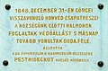
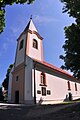
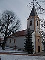
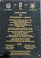
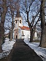
Magyar: Pesthidegkút-Ófalui Sarlós Boldogasszony plébániatemplom. Báró Kurtz János Ignácz (?–1713) építtette 1717-ban, de csak 1752-ben szentelték fel az Erzsébetet látogató Mária tiszteletére. 1764-ben bővítették. 1940-ben készült Tallós Móric díszítőfestése is a templombelsőben. Az épületen több emléktábla látható: magyar és német nyelvű műemléktábla, Görgey Artúr 1848 decemberi hadműveleteinek emléktáblája, a Pesthidegkút Baráti Kör táblája, Pesthidegkút német telepesek általi újraalapításának emléke, az 1945 február 13-i budai vári kitörés itteni elesettjeinek emléke, gróf Klebelsberg Kunó domborműves emléktáblája. [1] - Budapest, II. kerület, Pesthidegkút-Ófalu, Templom köz, Templom utca sarok.)
|
This is a category about a monument in Hungary. Identifier: 326 |
Subcategories
This category has the following 2 subcategories, out of 2 total.
Media in category "Church of the Visitation in Pesthidegkút"
The following 39 files are in this category, out of 39 total.
-

-
 1848 Templomköz1.jpg 1,615 × 1,069; 873 KB
-
 1945 február 13-i kitörés emléktáblája (2003), 2019 Pesthidegkút-Ófalu.jpg 1,374 × 1,097; 531 KB
-
 Budapest-Pesthidegkút, ófalui római katolikus templom 2021 01.jpg 1,600 × 2,400; 1.69 MB
-
 Budapest-Pesthidegkút, ófalui római katolikus templom 2021 02.jpg 1,600 × 2,400; 1.87 MB
-
 Budapest-Pesthidegkút, ófalui római katolikus templom 2021 03.jpg 1,600 × 2,400; 923 KB
-
 Budapest-Pesthidegkút, ófalui római katolikus templom 2021 04.jpg 1,600 × 2,400; 1.06 MB
-
 Budapest-Pesthidegkút, ófalui római katolikus templom 2021 05.jpg 1,600 × 3,200; 1.04 MB
-

-
 Church of the Visitation in Pesthidegkút 01.JPG 680 × 1,024; 379 KB
-
 Church of the Visitation in Pesthidegkút 02.JPG 680 × 1,024; 455 KB
-
 Church of the Visitation in Pesthidegkút 03.JPG 1,024 × 680; 428 KB
-
 Church of the Visitation in Pesthidegkút 04.JPG 680 × 1,024; 419 KB
-
 Church of the Visitation in Pesthidegkút 05.JPG 1,024 × 680; 401 KB
-
 Church of the Visitation, 2019 Pesthidegkút-Ófalu.jpg 1,704 × 2,272; 948 KB
-
 Church of the Visitation, blind window, 2019 Pesthidegkút-Ófalu.jpg 1,704 × 2,272; 979 KB
-
 Church of the Visitation, lamp, 2019 Pesthidegkút-Ófalu.jpg 1,496 × 2,180; 1.01 MB
-
 Count Klebelsberg Mansion and Church, 2019 Pesthidegkút-Ófalu.jpg 2,272 × 1,704; 940 KB
-
 Germains forced transfer from Pesthidegkut plaque.jpg 1,985 × 2,814; 3.32 MB
-
 II. Bezirk, Hidigut-Altdorf, Kirchengässchen und Kirche, 2019 Pesthidegkút-Ófalu.jpg 1,669 × 1,431; 748 KB
-
 Katolikus templom és plébánia, 2019 Pesthidegkút-Ófalu.jpg 2,272 × 1,704; 957 KB
-
 Kirchturm und Herrenhaus Klebelsberg, 2019 Pesthidegkút-Ófalu.jpg 2,272 × 1,704; 1,006 KB
-
 Mansion gate, Alpha and Omega sign, R.C. Church, 2019 Pesthidegkút-Ófalu.jpg 2,272 × 1,704; 951 KB
-
 Parish Church, 2019 Pesthidegkút-Ófalu.jpg 1,704 × 2,272; 993 KB
-
 Parish Church, cross, 2019 Pesthidegkút-Ófalu.jpg 944 × 1,259; 222 KB
-
 Pfarrkirche, 2019 Pesthidegkút-Ófalu.jpg 2,272 × 1,704; 983 KB
-
 Pfarrkirche, Kunstdenkmal, 2019 Pesthidegkút-Ófalu.jpg 1,914 × 1,281; 471 KB
-
 Plébániatemplom, 1848-as emléktábla, 2019 Pesthidegkút-Ófalu.jpg 1,731 × 1,128; 378 KB
-
 Plébániatemplom, ablak, 2019 Pesthidegkút-Ófalu.jpg 1,165 × 1,554; 330 KB
-
 Plébániatemplom, ajtó, 2019 Pesthidegkút-Ófalu.jpg 1,704 × 2,272; 975 KB
-
 Plébániatemplom, sétány, 2019 Pesthidegkút-Ófalu.jpg 1,704 × 2,272; 1.02 MB
-
 Plébániatemplom, torony, 2019 Pesthidegkút-Ófalu.jpg 1,567 × 2,089; 514 KB
-
 Sarlós Boldogasszony plébániatemplom, 2019 Pesthidegkút-Ófalu.jpg 2,272 × 1,704; 939 KB
-
 Sarlós Boldogasszony templom és szobor, 2019 Pesthidegkút-Ófalu.jpg 1,704 × 2,272; 911 KB
-
 Sarlós Boldogasszony templom, 2019 Pesthidegkút-Ófalu.jpg 1,302 × 1,872; 716 KB
-
 Statue at Church of the Visitation, 2019 Pesthidegkút-Ófalu.jpg 1,704 × 2,272; 1,002 KB
-
 Sétány a Sarlós Boldogasszony plébániatemplom előtt, 2019 Pesthidegkút-Ófalu.jpg 1,704 × 2,272; 965 KB
-
 Templom utca 11 és templom, 2019 Pesthidegkút-Ófalu.jpg 2,272 × 1,704; 976 KB
-
 World War I and II Memorial, 2019 Pesthidegkút-Ófalu.jpg 2,272 × 1,704; 960 KB


,_2019_Pesthidegk%C3%BAt-%C3%93falu.jpg)


Categories:
- Churches of the Visitation in Hungary
- Roman Catholic churches in Budapest District II
- Cultural heritage monuments in Budapest District II
- Templom utca (Pesthidegkút-Ófalu)
- Churches in Pesthidegkút
- Parish churches in Budapest
- Parish churches in the Roman Catholic Archdiocese of Esztergom-Budapest
- Baroque churches in Hungary
- 18th-century churches in Hungary