Category:Church of the Holy Trinity (Sokolivka)
Jump to navigation
Jump to search
| Object location | | View all coordinates using: OpenStreetMap |
|---|
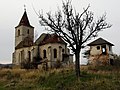
church building in Sokolivka, Ukraine  | |||||
| Upload media | |||||
| Instance of | |||||
|---|---|---|---|---|---|
| Location | Sokolivka, Stryi Raion, Lviv Oblast, Ukraine | ||||
| Date of official closure |
| ||||
| Dissolved, abolished or demolished date |
| ||||
 | |||||
Subcategories
This category has only the following subcategory.
Media in category "Church of the Holy Trinity (Sokolivka)"
The following 19 files are in this category, out of 19 total.
-
 Church of the Holy Trinity, Sokolivka 1.JPG 3,456 × 4,608; 3.46 MB
-
 Church of the Holy Trinity, Sokolivka 10.JPG 3,456 × 4,608; 3.45 MB
-
 Church of the Holy Trinity, Sokolivka 11.JPG 4,608 × 3,456; 3.17 MB
-
 Church of the Holy Trinity, Sokolivka 12.JPG 4,608 × 3,456; 3.35 MB
-
 Church of the Holy Trinity, Sokolivka 13.JPG 3,456 × 4,608; 3.33 MB
-
 Church of the Holy Trinity, Sokolivka 14.JPG 4,608 × 3,456; 3.28 MB
-
 Church of the Holy Trinity, Sokolivka 15.JPG 3,456 × 4,608; 3.3 MB
-
 Church of the Holy Trinity, Sokolivka 16.JPG 4,608 × 3,456; 3.29 MB
-
 Church of the Holy Trinity, Sokolivka 17.JPG 3,456 × 4,608; 3.43 MB
-
 Church of the Holy Trinity, Sokolivka 2.JPG 3,456 × 4,608; 3.39 MB
-
 Church of the Holy Trinity, Sokolivka 20.JPG 3,456 × 4,608; 3.35 MB
-
 Church of the Holy Trinity, Sokolivka 21.JPG 3,456 × 4,608; 3.28 MB
-
 Church of the Holy Trinity, Sokolivka 22.JPG 4,608 × 3,456; 3.35 MB
-
 Church of the Holy Trinity, Sokolivka 5.JPG 4,608 × 3,456; 3.33 MB
-
 Church of the Holy Trinity, Sokolivka 7.JPG 4,608 × 3,456; 3.18 MB
-
 Church of the Holy Trinity, Sokolivka 8.JPG 4,608 × 3,456; 3.35 MB
-
 Church of the Holy Trinity, Sokolivka 9.JPG 3,456 × 4,608; 3.24 MB
-
 Костел Святої Трійці 1594 с.Соколівка.jpg 5,000 × 5,000; 5.72 MB
-
 Костел Святої Трійці. Соколівка.jpg 1,600 × 1,200; 327 KB


