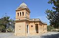
Category:Church of St. Oswald, Mtarfa
Jump to navigation
Jump to search
| Object location | | View all coordinates using: OpenStreetMap |
|---|
church in Mtarfa, Malta  | |||||
| Upload media | |||||
| Instance of | |||||
|---|---|---|---|---|---|
| Dedicated to | |||||
| Location | Mtarfa, Northern Region (Tramuntana), Malta | ||||
| Inception |
| ||||
| Religion or worldview | |||||
 | |||||
Media in category "Church of St. Oswald, Mtarfa"
The following 4 files are in this category, out of 4 total.
-
 Church of St Oswald, Malta.jpg 2,048 × 1,357; 440 KB
-
 Church of St Oswald, Mtarfa.jpg 2,048 × 1,353; 387 KB
-
 Church of St Oswald.jpg 2,048 × 1,353; 504 KB
-
 The Church of St Oswald, Mtarfa Malta.jpg 4,777 × 3,164; 7.89 MB


