Category:Church of Saint Paulinus, St Paul's Cray
Jump to navigation
Jump to search
This is a category about listed building number 1064396. |
| Object location | | View all coordinates using: OpenStreetMap |
|---|
church in the London Borough of Bromley, England,UK  | |||||
| Upload media | |||||
| Instance of | |||||
|---|---|---|---|---|---|
| Location | London Borough of Bromley, Greater London, London, England | ||||
| Heritage designation |
| ||||
 | |||||
Subcategories
This category has only the following subcategory.
Media in category "Church of Saint Paulinus, St Paul's Cray"
The following 22 files are in this category, out of 22 total.
-
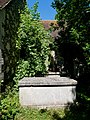 Chest Tombs to the Southeast of the Church of Saint Paulinus, St Paul's Cray.jpg 3,448 × 4,592; 18.7 MB
-
 Detail in the Lychgate at Saint Paulinus' Church, St Paul's Cray.jpg 3,194 × 4,365; 14.98 MB
-
 Detail of the Northern Wall of the Church of Saint Paulinus, St Paul's Cray.jpg 3,448 × 4,592; 18.45 MB
-
 Detail of the Tower on the Church of Saint Paulinus, St Paul's Cray.jpg 3,448 × 4,592; 15.39 MB
-
 Detail on the Western Door of Saint Paulinus' Church, St Paul's Cray.jpg 3,448 × 4,592; 11.17 MB
-
 Eastern End of the Church of Saint Paulinus, St Paul's Cray.jpg 3,448 × 4,592; 17.36 MB
-
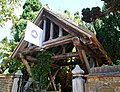 Lychgate of the Church of Saint Paulinus, St Paul's Cray.jpg 4,365 × 3,339; 14.45 MB
-
 Northern Side of the Church of Saint Paulinus in St Paul's Cray.jpg 3,448 × 4,592; 18.57 MB
-
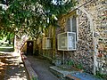 Northern Side of the Church of Saint Paulinus, St Paul's Cray.jpg 4,592 × 3,448; 18.77 MB
-
 Roofing Detail of the Church of Saint Paulinus, St Paul's Cray.jpg 4,152 × 3,043; 12.92 MB
-

-
 Signage on the Lychgate of the Church of Saint Paulinus, St Paul's Cray.jpg 4,592 × 3,448; 9.79 MB
-
 Southern Side of the Church of Saint Paulinus, St Paul's Cray.jpg 3,448 × 4,592; 17.43 MB
-
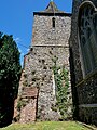 Southern Side of the Tower at the Church of Saint Paulinus, St Paul's Cray.jpg 3,448 × 4,592; 17.03 MB
-
 Tower of the Church of Saint Paulinus, St Paul's Cray.jpg 3,448 × 4,592; 16.45 MB
-
 Two Windows on the Northern Side of Saint Paulinus' Church, St Paul's Cray.jpg 4,592 × 3,448; 17.81 MB
-
 West Face of the Church of Saint Paulinus in Saint Paul's Cray (01).jpg 3,062 × 3,955; 10.71 MB
-
 West Face of the Church of Saint Paulinus in Saint Paul's Cray (02).jpg 4,254 × 3,056; 13.76 MB
-
 Western Doorway on the Church of Saint Paulinus, St Paul's Cray.jpg 3,187 × 4,269; 13.47 MB
-
 Window on the Eastern Side of the Church of Saint Paulinus, St Paul's Cray.jpg 3,448 × 4,592; 17.53 MB
-
 Window on the Northern Side of Saint Paulinus' Church, St Paul's Cray.jpg 3,200 × 4,274; 16.53 MB
-
 Window on the Western Side of the Tower at the Church of Saint Paulinus, St Paul's Cray.jpg 4,592 × 3,448; 17.88 MB


.jpg)
.jpg)


Categories:
- 11th-century churches in London
- St Paul's Cray
- Grade II* listed churches in the London Borough of Bromley
- Pentecostal churches in London
- Saint Paulinus churches in England
- Flint churches in London
- 13th-century church towers in London
- Former Anglican churches in London
- Redeemed Christian Church of God
- Hall churches in London