Category:Church in Trebenow (Uckermark)
Jump to navigation
Jump to search
| Object location | | View all coordinates using: OpenStreetMap |
|---|
church building in Brandenburg state, Germany _2017_NE.jpg) | |||||
| Upload media | |||||
| Instance of | |||||
|---|---|---|---|---|---|
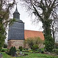
| Location | Trebenow, Uckerland, Uckermark District, Brandenburg, Germany | ||||
| Heritage designation | |||||
 | |||||
This is the category of the Brandenburger Baudenkmal (cultural heritage monument) with the ID 09130710 (Wikidata)
|
Deutsch: Kirche in Trebenow, Gemeinde Uckerland, Landkreis Uckermark, Land Brandenburg, Deutschland.
Français : Église de Trebenow, commune de Uckerland, arrondissement Uckermark, état fédéral de Brandebourg, Allemagne
Media in category "Church in Trebenow (Uckermark)"
The following 7 files are in this category, out of 7 total.
-
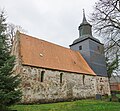 Dorfkirche Trebenow (Uckermark) 2017 NE.jpg 5,103 × 4,733; 10.64 MB
-
 Dorfkirche Trebenow (Uckermark) 2017 NW.jpg 4,864 × 3,648; 7.19 MB
-
 Dorfkirche Trebenow (Uckermark) 2017 Portal.jpg 3,648 × 4,864; 7.13 MB
-
 Dorfkirche Trebenow (Uckermark) 2017 SW.jpg 4,002 × 4,011; 8.74 MB
-
 Dorfkirche Trebenow (Uckermark) 2017 Turm N.jpg 4,864 × 3,648; 8.41 MB
-
 Dorfkirche Trebenow (Uckermark) 2017 vermauertes Portal N.jpg 3,648 × 4,864; 7.23 MB
-
 Dorfkirche Trebenow (Uckermark) 2017 vermauertes Portal S.jpg 3,648 × 4,864; 8.07 MB
_2017_NW.jpg)
_2017_Portal.jpg)
_2017_SW.jpg)
_2017_Turm_N.jpg)
_2017_vermauertes_Portal_N.jpg)
_2017_vermauertes_Portal_S.jpg)