Category:Church in Schwaneberg (Randowtal)
Jump to navigation
Jump to search
| Object location | | View all coordinates using: OpenStreetMap |
|---|
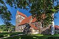
church building in Brandenburg state, Germany _2018_SSE.jpg) | |||||
| Upload media | |||||
| Instance of | |||||
|---|---|---|---|---|---|
| Location | Schwaneberg, Randowtal, Randowtal, Uckermark District, Brandenburg, Germany | ||||
| Heritage designation | |||||
 | |||||
This is the category of the Brandenburger Baudenkmal (cultural heritage monument) with the ID 09130160 (Wikidata)
|
Deutsch: Ansichten der Kirche in Schwaneberg, Gemeinde Randowtal, Landkreis Uckermark, Land Brandenburg, Deutschland.
English: Pictures of the church in Schwaneberg, Randowtal municipality, Uckermark district, Brandenburg state, Germany.
Français : Photos de l'église à Schwaneberg, commune de Randowtal, arrondissement de Uckermark, état fédéral de Brandebourg, Allemagne
Español: Vistas de la iglesia en Schwaneberg, municipio de Randowtal, distrito de Uckermark, estado federado de Brandeburgo, Alemania
Media in category "Church in Schwaneberg (Randowtal)"
The following 10 files are in this category, out of 10 total.
-
 Dorfkirche Schwaneberg (Randowtal) 2018 ENE.jpg 4,701 × 4,778; 6.39 MB
-
 Dorfkirche Schwaneberg (Randowtal) 2018 S.jpg 4,864 × 3,648; 8.19 MB
-
 Dorfkirche Schwaneberg (Randowtal) 2018 SSE.jpg 4,864 × 3,648; 4.58 MB
-
 Dorfkirche Schwaneberg (Randowtal) 2018 Südportal.jpg 3,482 × 4,744; 8.79 MB
-
 Dorfkirche Schwaneberg (Randowtal) 2018 vermauertes Nordportal.jpg 4,834 × 3,608; 7.08 MB
-
 Dorfkirche Schwaneberg (Randowtal) 2018 vermauertes Südportal.jpg 3,648 × 4,864; 6.24 MB
-
 Dorfkirche Schwaneberg (Randowtal) 2018 Westportal.jpg 4,864 × 3,648; 5.28 MB
-
 Dorfkirche Schwaneberg (Randowtal) 2018 WNW.jpg 3,498 × 4,754; 6.07 MB
-

-
 Schwaneberg 08 17 01 jiw.jpg 1,920 × 1,280; 912 KB
_2018_ENE.jpg)
_2018_S.jpg)
_2018_S%C3%BCdportal.jpg)
_2018_vermauertes_Nordportal.jpg)
_2018_vermauertes_S%C3%BCdportal.jpg)
_2018_Westportal.jpg)
_2018_WNW.jpg)
_-_geo.hlipp.de_-_4085.jpg)
