Category:Church in Schrepkow
Jump to navigation
Jump to search
| Object location | | View all coordinates using: OpenStreetMap |
|---|
 | |||||
| Upload media | |||||
| Instance of | |||||
|---|---|---|---|---|---|
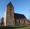
| Location | Schrepkow, Gumtow, Prignitz District, Brandenburg, Germany | ||||
| Heritage designation | |||||
 | |||||
This is the category of the Brandenburger Baudenkmal (cultural heritage monument) with the ID 09160574 (Wikidata)
|
Français : Église de Schrepkow, commune de Gumtow, arrondissement Prignitz, état fédéral de Brandebourg, Allemagne
Media in category "Church in Schrepkow"
The following 10 files are in this category, out of 10 total.
-
 Dorfkirche Schrepkow 2017 NE.jpg 4,745 × 4,478; 9.54 MB
-
 Dorfkirche Schrepkow 2017 NNW.jpg 4,639 × 4,475; 8.14 MB
-
 Dorfkirche Schrepkow 2017 NW.jpg 4,864 × 3,648; 5.32 MB
-
 Dorfkirche Schrepkow 2017 Portal vermauert.jpg 3,648 × 4,864; 7.34 MB
-
 Dorfkirche Schrepkow 2017 Portal W.jpg 3,552 × 4,792; 6.98 MB
-
 Dorfkirche Schrepkow 2017 S.jpg 4,864 × 3,648; 4.7 MB
-
 Dorfkirche Schrepkow 2017 SE.jpg 3,648 × 4,864; 5.89 MB
-
 Dorfkirche Schrepkow 2017 SSE.jpg 4,864 × 3,648; 6.96 MB
-
 Dorfkirche Schrepkow 2017 SW.jpg 4,518 × 4,376; 8.4 MB
-
 Dorfkirche Schrepkow 2017 W.jpg 3,648 × 4,864; 5.3 MB


