Category:Church in Schmolde
Jump to navigation
Jump to search
| Object location | | View all coordinates using: OpenStreetMap |
|---|
 | |||||
| Upload media | |||||
| Instance of | |||||
|---|---|---|---|---|---|
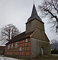
| Location | Schmolde, Meyenburg, Prignitz District, Brandenburg, Germany | ||||
| Heritage designation | |||||
 | |||||
This is the category of the Brandenburger Baudenkmal (cultural heritage monument) with the ID 09160573 (Wikidata)
|
Deutsch: Dorfkirche in Schmolde, Stadt Meyenburg, Landkreis Prignitz, Land Brandenburg, Deutschland.
Français : Église de Schmolde, ville de Meyenburg, arrondissement Prignitz, état fédéral de Brandebourg, Allemagne
Media in category "Church in Schmolde"
The following 11 files are in this category, out of 11 total.
-
 Dorfkirche Schmolde 2017 E.jpg 3,506 × 4,760; 7.53 MB
-
 Dorfkirche Schmolde 2017 NW.jpg 4,631 × 4,774; 8.19 MB
-
 Dorfkirche Schmolde 2017 Portal S.jpg 3,648 × 4,864; 5.21 MB
-
 Dorfkirche Schmolde 2017 Portal W.jpg 3,648 × 4,864; 6.07 MB
-
 Dorfkirche Schmolde 2017 SE.jpg 4,634 × 4,412; 10.7 MB
-
 Dorfkirche Schmolde 2017 SW.jpg 4,026 × 4,805; 7.6 MB
-
 Luisenlinde Schmolde 2017 NE.jpg 4,864 × 3,648; 7.17 MB
-
 Schmolde - DK NO.jpg 5,184 × 3,456; 4.84 MB
-
 Schmolde - DK O.jpg 5,069 × 3,379; 3.16 MB
-
 Schmolde - DK SO.jpg 3,218 × 4,827; 3.06 MB
-
 Schmolde - DK SW.jpg 3,307 × 4,961; 4.44 MB


