Category:Church in Klosterwalde
Jump to navigation
Jump to search
| Object location | | View all coordinates using: OpenStreetMap |
|---|
 | |||||
| Upload media | |||||
| Instance of | |||||
|---|---|---|---|---|---|
| Location | Klosterwalde, Templin, Uckermark District, Brandenburg, Germany | ||||
| Heritage designation | |||||
 | |||||
This is the category of the Brandenburger Baudenkmal (cultural heritage monument) with the ID 09130529 (Wikidata)
|
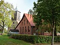
English: Church in Klosterwalde, Templin municipality, Uckermark district, Brandenburg state, Germany
Français : Église de Klosterwalde, ville de Templin, arrondissement Uckermark, état fédéral de Brandebourg, Allemagne
Media in category "Church in Klosterwalde"
The following 10 files are in this category, out of 10 total.
-
 Dorfkirche Klosterwalde 2017 E.jpg 3,522 × 4,772; 6.12 MB
-
 Dorfkirche Klosterwalde 2017 Friedhofsmauer.jpg 4,864 × 3,648; 9.36 MB
-
 Dorfkirche Klosterwalde 2017 NNE.jpg 4,864 × 3,648; 6.09 MB
-
 Dorfkirche Klosterwalde 2017 NNW.jpg 5,059 × 4,641; 9.77 MB
-
 Dorfkirche Klosterwalde 2017 Portal S.jpg 3,532 × 4,780; 7.92 MB
-
 Dorfkirche Klosterwalde 2017 Portal W.jpg 4,864 × 3,648; 8.42 MB
-
 Dorfkirche Klosterwalde 2017 SE.jpg 4,864 × 3,648; 7.22 MB
-
 Dorfkirche Klosterwalde 2017 SW.jpg 3,648 × 4,864; 7.55 MB
-
 Dorfkirche Klosterwalde 2017 vermauertes Portal.jpg 3,648 × 4,864; 8.19 MB
-
 Dorfkirche und ehemalige Schule Klosterwalde 2017 SW.jpg 4,864 × 3,648; 8.37 MB


