Category:Church in Groß Trebbow
Jump to navigation
Jump to search
| Object location | | View all coordinates using: OpenStreetMap |
|---|
church  | |||||
| Upload media | |||||
| Instance of | |||||
|---|---|---|---|---|---|
| Made from material | |||||
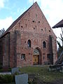
| Location | Klein Trebbow, Nordwestmecklenburg District, Mecklenburg-Western Pomerania, Germany | ||||
| Architectural style | |||||
| Heritage designation | |||||
 | |||||
Media in category "Church in Groß Trebbow"
The following 17 files are in this category, out of 17 total.
-
 Gross Trebbow Kirche 2008-11-13 014.jpg 2,048 × 1,536; 962 KB
-
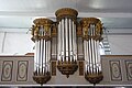
 Groß Trebbow Kirche Orgel (01).jpg 3,539 × 5,389; 14.43 MB
-
 Groß Trebbow Kirche Orgel (02).jpg 3,648 × 5,472; 13.75 MB
-
 Groß Trebbow Kirche Orgel (03).jpg 5,362 × 3,569; 16.07 MB
-
 Groß Trebbow Kirche Orgel (04).jpg 5,426 × 3,569; 16.09 MB
-
 Groß Trebbow Kirche 2013-03-02 10.JPG 3,072 × 2,304; 2.74 MB
-
 Groß Trebbow Kirche 2013-03-02 11.JPG 3,072 × 2,304; 2.95 MB
-
 Groß Trebbow Kirche 2013-03-02 12.JPG 2,304 × 3,072; 2.97 MB
-
 Groß Trebbow Kirche 2013-03-02 14.JPG 3,072 × 2,304; 2.83 MB
-
 Groß Trebbow Kirche 2013-03-02 2.JPG 2,304 × 3,072; 3 MB
-
 Groß Trebbow Kirche 2013-03-02 3.JPG 2,304 × 3,072; 3.14 MB
-
 Groß Trebbow Kirche 2013-03-02 4.JPG 3,072 × 2,304; 2.95 MB
-
 Groß Trebbow Kirche 2013-03-02 5.JPG 2,304 × 3,072; 3.09 MB
-
 Groß Trebbow Kirche 2013-03-02 7.JPG 3,072 × 2,304; 2.92 MB
-
 Groß Trebbow Kirche 2013-03-02 8.JPG 3,072 × 2,304; 3.03 MB
-
 Groß Trebbow Kirche 2013-03-02 9.JPG 2,304 × 3,072; 3.2 MB
-
 Groß Trebbow Kirche 2013-03-02.JPG 3,072 × 2,304; 3.07 MB

.jpg)
.jpg)
.jpg)
.jpg)


