Category:Church in Bälow
Jump to navigation
Jump to search
| Object location | | View all coordinates using: OpenStreetMap |
|---|
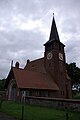
This is the category of the Brandenburger Baudenkmal (cultural heritage monument) with the ID 09160548 (Wikidata)
|
church building in Brandenburg state, Germany  | |||||
| Upload media | |||||
| Instance of | |||||
|---|---|---|---|---|---|
| Location | Bälow, Rühstädt, Prignitz District, Brandenburg, Germany | ||||
| Heritage designation | |||||
 | |||||
Media in category "Church in Bälow"
This category contains only the following file.
-
 Dorfkirche Bälow Rühstädt.jpg 2,592 × 3,872; 3.56 MB